Public Lands Are on the Line
Trump and his allies are targeting our shared, wild spaces for extraction
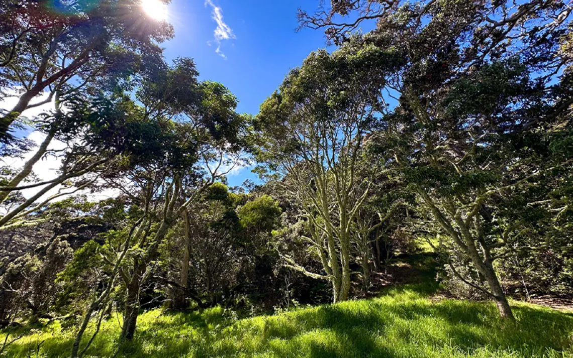
Los Padres may see increased logging in the name of wildfire risk reduction. | Photo by Wray Sinclair
On a chilly morning in mid-July, Bryant Baker and I set out into the rugged country outside Ventura, California, an hour north of Los Angeles. A month earlier, in the nearby town of Oxnard, immigration-enforcement officers had chased farmworkers across fields of strawberries. Baker, the conservation and research director for the Santa Barbara–based environmental group Los Padres ForestWatch, wanted to show me part of another, quieter front in President Donald Trump’s war on California: the state’s public lands.
We drove north, tracking the Ventura River. Over millennia, boulders had tumbled down into the river-bed from the towering peaks of the Sespe, Matilija, and Dick Smith Wilderness areas. We were headed into the heart of the region’s largest parcel of public land, the Los Padres National Forest.
Baker wore a green T-shirt, and his ponytail poked out the bottom of a green mesh hat. He piloted his Subaru through oak woodlands and vast expanses of chaparral while rattling off the scientific names of deciduous and coniferous trees as we passed them.
Baker holds a master’s degree in environmental science from the University of Arkansas. In the well-wooded and watered forests of his native state, his work focused primarily on the effects of poultry farms’ agricultural runoff into rivers and lakes. He noted how different Los Padres is from the Ozark Mountains. “Most creeks around here don’t flow year-round,” he said.
Baker has worked for ForestWatch since 2016, cutting his teeth during Trump’s first term as the president was trying to reduce the size of Bears Ears and Grand Staircase–Escalante National Monuments by as much as 80 percent. “Huge, huge reductions,” Baker said, “which we’d never really seen before.” To him, the administration’s rationale was clear. “They were looking at public lands as, ‘OK, well, what can we do with these? Can we drill? Can we log?’” Three years later, the Trump administration issued proposals for logging in Los Padres National Forest, including one for the Pine Mountain Project. ForestWatch and local coalition partners filed a lawsuit to block the proposal and lost.
Now there’s another push for logging in the Los Padres—this time under the guise of wildfire risk management. ForestWatch and other environmental groups fought a 2022 Biden-era proposal to log and thin huge swaths of the Los Padres. The Trump administration took over the proposal, renaming it the Wildfire Risk Reduction Project. After extensive community resistance, the administration reduced the project’s scope from 235,000 acres to 90,000.
But the fight isn’t over. These efforts, Baker said—to profit off public lands—are now coming fast and furious.
Ventura County is uniquely vulnerable to an attack on public lands protections. Nearly half the county’s 1,000 square miles of rugged mountains, undulating coastal hills, and jagged coastlines are owned and managed by the federal government. The region’s best known federal property is Channel Islands National Park, a chain of windswept islands that harbor rare species of plants and animals—some of which are found nowhere else on Earth. The largest landholder in the county is the US Forest Service, which oversees 561,000 acres, much of it contained in remote wilderness areas.
In the late 19th and early 20th centuries, before the federal acquisition of large swaths of land nationwide, industry ran roughshod across Ventura County. Its diverse forests and deposits of minerals, strewn amid the coastal mountains and canyons, had been divvied up by the General Land Office, the Bureau of Land Management’s precursor, often to the highest bidder. Miners dug deep pits in the mountainsides in search of gold, silver, copper, and zinc. One of the most prized commodities was quicksilver, or mercury, used in vast quantities in the gold mines of the Sierra Nevada to separate gold from rock. Today, the Santa Ynez Mountains are pockmarked with dozens of abandoned mercury mines.
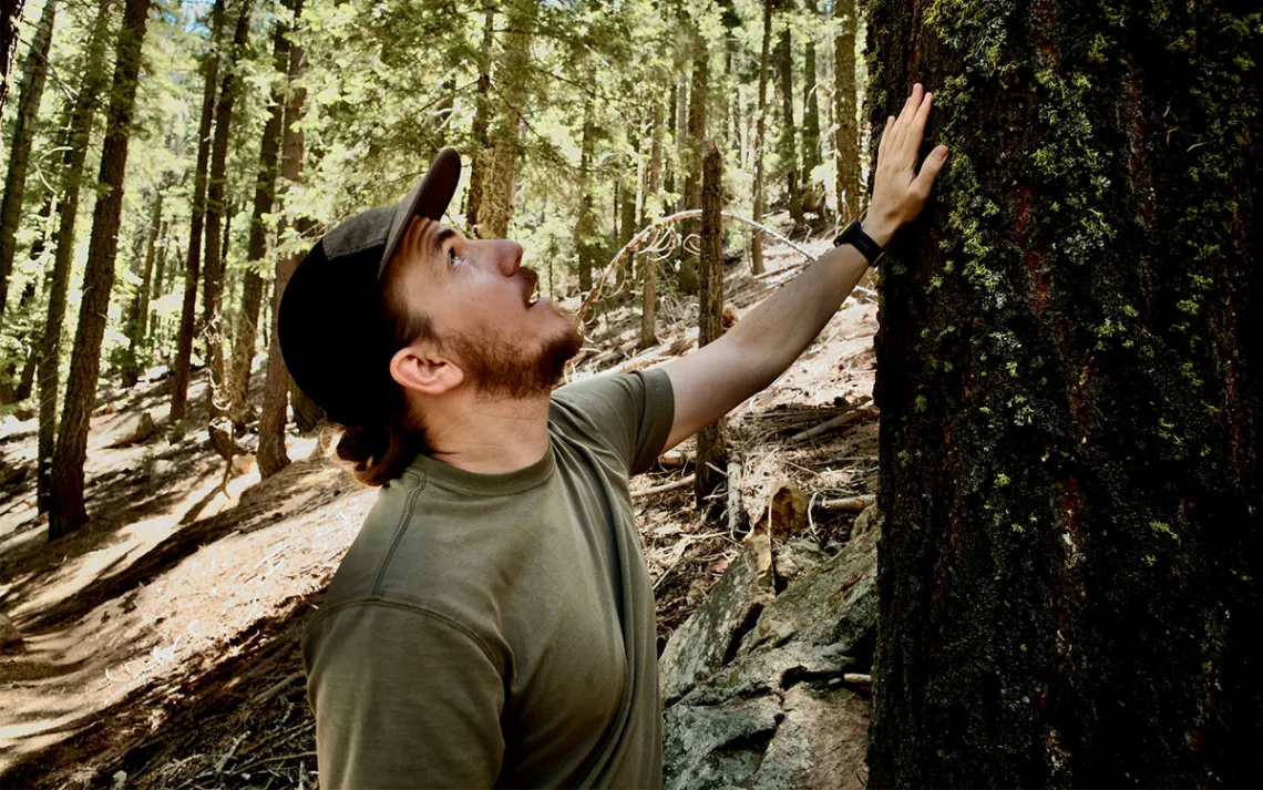
Bryant Baker, from Los Padres ForestWatch, works to protect California’s Los Padres National Forest and its many conifer species. | Photo by Jeremy Miller
Ventura County’s largest extractable resource, though, was the tarry oil found in deep underground marine deposits laid down during the Miocene Epoch, between 6 and 17 million years ago. Between 1920 and 1930, fortune hunters surged into the area, and the county’s population nearly doubled. Oil extraction required a wealth of raw materials, including vast quantities of wood. Much of the lumber for oil derricks came by rail from the Sierra Nevada, but some was sourced locally, from the big-cone spruces and Jeffrey pines that stippled the Santa Ynez Mountains. Whole stands were felled. Low-lying vegetable fields and citrus groves filled with drilling equipment as petroleum titans Union, Shell, and Associated, along with a host of smaller oil producers, fanned out. In the coastal town of Summerland, the skeletal frames of oil wells extended as far as the eye could see. By 1954, the Ventura Oil Field was the 12th-largest oil field in the United States, producing some 31 million barrels a year.
This unbridled industrial excess here and throughout the country’s resource-rich provinces led to the creation of the United States’ federal land-management agencies, including the Forest Service in 1905. The mission of the agency, established during the Theodore Roosevelt presidency, was to steward and preserve the nation’s forests, protect the water quality and flow of rivers that supplied water to downstream communities, and ensure an orderly process for supplying timber.
Since its founding, the Forest Service has acquired and purchased close to 200 million acres of land held in 154 units across the United States. Los Padres National Forest, established in 1936, was pieced together from a checkerboard of reserves scattered between Monterey and Los Angeles. The forest was initially 1.75 million acres, just shy of the 1.95 million acres contained within its boundaries today. Now Los Padres is the second-largest national forest in California, after Shasta-Trinity. Among its tracts of chaparral, oak, and conifers are 10 official wilderness areas accounting for nearly half its total acreage.
These remote reaches, off-limits to the heavy machinery of the logger, driller, and miner, have long been coveted by industry—a kind of piggy bank of resources waiting to be cracked open.
In 1905, the Forest Service’s first administrator, Gifford Pinchot, described the fledgling agency’s delicate balancing act among resource extraction, recreation, and conservation: “Where conflicting interests must be reconciled, the question shall always be answered from the standpoint of the greatest good of the greatest number in the long run.” Those words would inspire the Forest Service’s famed motto, “Land of many uses.”
Over the past half century, the “many uses” of the Los Padres National Forest have shifted from extraction to tourism. Every year, millions of visitors, drawn to the area’s natural beauty and its wild, open terrain, flock to its beaches and to trails cutting through the mountains and canyons. It’s not just Los Padres that draws hikers, climbers, and adventure seekers. In 2023, Ventura County’s iconic national park, Channel Islands, received 328,000 visitors.
For the protected lands of Ventura County, and many others across the United States, all that could change under Trump 2.0.
The Trump administration has issued a raft of orders aimed at increasing logging, mining, and oil and gas production on public lands. One of those orders, unambiguously titled “Immediate Expansion of American Timber Production,” mandates an increase in logging, including the opening of some 280 million acres, or 437,500 square miles—an area nearly two and a half times the size of California—to the timber industry.
While he seeks to give a leg up to the mining and logging industries, Trump is trying to supercharge the fossil fuel industry—just as the planet is tipping past the Paris Agreement’s crucial 1.5°C threshold of global warming. Along with deforestation and animal agriculture, the extraction and burning of fossil fuels for energy is a significant source of planet-heating greenhouse gas emissions. Regardless, Trump has vowed to “drill, baby, drill,” including on sensitive federal lands from the Arctic National Wildlife Refuge to California’s Central Coast. His administration is also pursuing sweeping rollbacks of rules meant to hold companies accountable for cleanups and remediating abandoned oil and gas wells. And Trump is actively attacking the renewable energy sector. His One Big Beautiful Bill gutted much of the Inflation Reduction Act’s green energy subsidies and tax breaks, and he eliminated a 2024 rule meant to spur green energy projects on federal lands.
Meanwhile, the Trump administration has waged an unrelenting attack on the workforce that manages public lands. Weeks after Trump assumed office, as part of the “Workforce Optimization Initiative,” the Elon Musk–led Department of Government Efficiency laid off 3,400 workers from the Forest Service, 800 from the Bureau of Land Management, and about 1,000 from the National Park Service. Many of those fired were seasonal employees and probationary workers with less than a year on the job. In May, a federal court found the firings unlawful and ordered the reinstatement of the workers. But in July, the Supreme Court, via its “shadow docket,” paused that decision, allowing the firings to proceed. A constant atmosphere of doubt, uncertainty, and fear hangs over the Park Service, according to one staff member who was fired and then rehired at a California park. “You just never know when you are going to wake up to find that you don’t have a job again,” said the staffer, who requested anonymity out of fear of retaliation. “It’s no way to run an agency.”
“It’s a disaster,” said Tom Puchlerz, a former Forest Service worker who retired in 2009.
During his four-decade tenure, Puchlerz worked his way up the ranks, from seasonal temp to regional director. He served in Alaska, Montana, Wyoming, Oregon, Washington, and Idaho. Some government projections, he noted, call for 40 percent staff reductions. “How does one expect to provide the services to the public that the public is expecting and the agency is required to do by law?” he said.
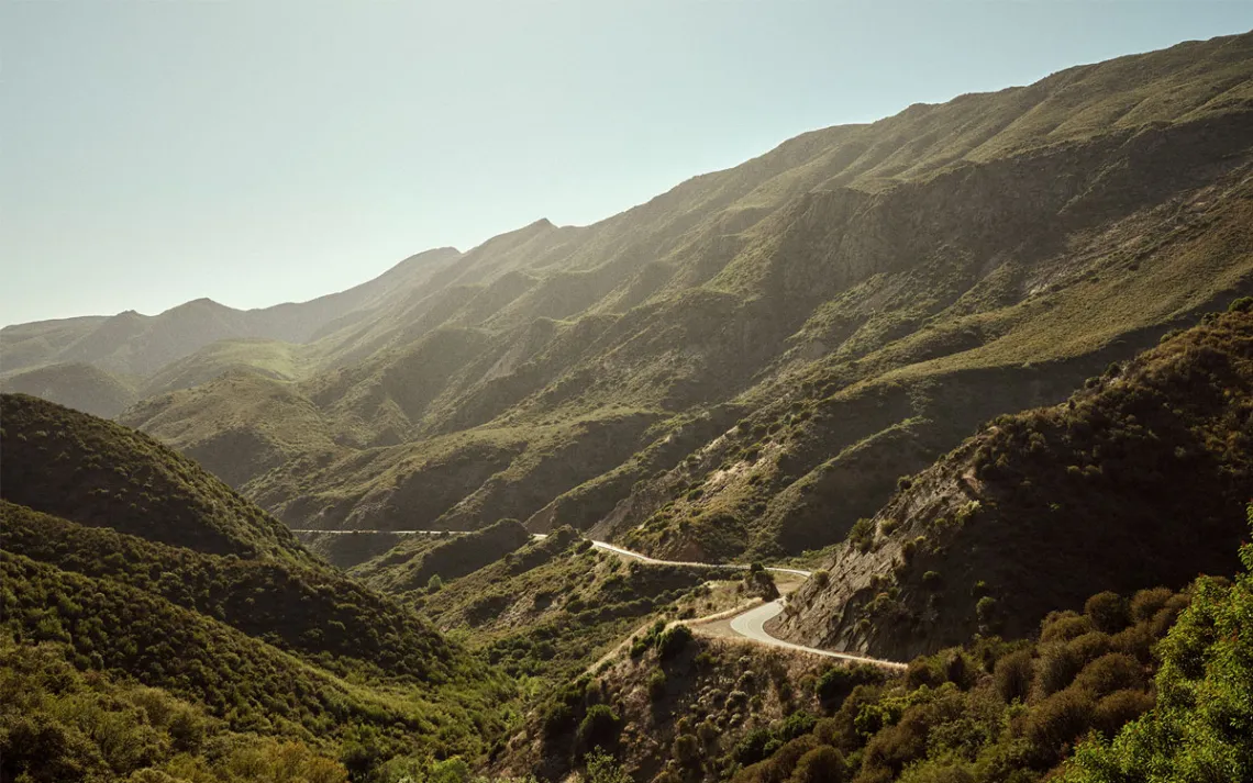
Highway 33 winds through Los Padres National Forest near Ojai. | Photo by Wray Sinclair
Campgrounds, Puchlerz predicted, will close, trails will be shut down, and roads will be gated. “These lands must be managed,” he said. “You’ve got to have somebody to pump a toilet. You’ve got to have somebody to clear a trail. You’ve got to have somebody to educate and to monitor backcountry campsites.”
Puchlerz is concerned about what he considers the most critical areas in the Forest Service’s inventory—its roadless and wilderness areas. These remote reaches, off-limits to the heavy machinery of the logger, driller, and miner, have long been coveted by industry—a kind of piggy bank of resources waiting to be cracked open. But these areas “are so valuable for clean water and wildlife security,” he said. “In losing the ability to have the people, to have the professionals, and to have the science to manage those areas—that’s an ecological disaster waiting to happen.”
But now the Roadless Rule—the federal policy that prohibits road building, reconstruction, and timber harvesting on 58.5 million acres of public lands—is itself under fire. In June, Secretary of Agriculture Brooke L. Rollins announced that her agency will rescind the rule.
These wild places—which happen to be the kind that backpackers, hunters, and fishermen alike seek out—are the heart of our public lands.
The sun began to pierce the fog as Baker and I negotiated Highway 33, weaving through the slot canyon of Matilija Creek into the chaparral of the Santa Ynez Mountains. In spring, wildflowers punctuate these dry mountainsides. The most stunning are the white-and-yellow “fried egg” Matilija poppies, their five-foot blooms bursting from cracks in the cliff walls.
Ventura’s federal lands harbor some of the country’s most iconic and threatened species. Deep within the arid pines of Los Padres National Forest lies the Sespe Condor Sanctuary, a 53,000-acre reserve critical to the California condor’s revival in the 1990s, after fewer than 30 animals remained in the wild.
Now the Los Padres regional office, along with its staff of biologists and technicians that oversee Endangered Species Act programs for the entire California Central Coast, could be at risk.
In spring, wildflowers punctuate these dry mountainsides. the most stunning are the white-and-yellow “fried egg” matilija poppies, their five-foot blooms bursting from cracks in the cliff walls.
Below us, fold after rugged fold of mountains swept to the blue waters of the Pacific Ocean. On the horizon, the rocky masses of the Channel Islands rose from the water like the backs of breaching whales—a reminder that the federal government’s holdings in Ventura County extend well beyond the shoreline. The Channel Islands and Chumash Heritage National Marine Sanctuaries, managed by the Department of Commerce, protect a vast swath of ocean along the Ventura, Santa Barbara, and San Luis Obispo County coasts. Like their counterparts on land, these protected areas are under threat. The Department of Government Efficiency has slashed the marine sanctuaries’ budgets, putting essential conservation work on the line.
The goal of stripping offshore protections is to spur offshore oil drilling (which has seen a sharp decline in recent years). In May, Texas-based Sable Offshore Corp. began producing oil on one of three platforms that had been shuttered for a decade. The other two will begin operating later this year. Coincidentally, the recommissioning of the platforms once owned by ExxonMobil came almost
10 years after the Refugio spill in 2015, when a pipeline ruptured and released 123,228 gallons of oil, polluting a 100-mile stretch of coastline.
We turned off the highway onto a winding, narrow road and followed it across a rolling ridge full of Jeffrey pines. More than a mile below, the marine layer clung tightly to the coast, giving our perch the feel of an island in the sky.
As we climbed the road, the forest became denser and more shaded. Several hikers walked along the shoulder, beside outcroppings that jutted from the mountainside like massive stone heads. We were now fully within the boundaries of the proposed Pine Mountain Project. We approached the end of the road, where a trail to the summit of Reyes Peak begins, and Baker gestured to a treeless expanse covered in a thick carpet of invasive and highly flammable cheatgrass. “The Forest Service went in here and cut a few dead trees,” said Baker. “This was a safety thing, but that little bit of disturbance has let the cheatgrass get in here.”
If the Trump administration succeeds in its aim, many of the nation’s legacy environmental rules and regulations will be jettisoned. That could open the door to policies around forest management that won’t actually protect and conserve those lands. The administration is also trying to make it more difficult for the public to weigh in on decisions, allowing agencies to sidestep the release of draft versions of projects and circumvent public comment periods.
Baker described the intensive logging and thinning that has been proposed, which, according to the scoping documents, would remove all trees smaller than 24 inches in diameter. “When you go in here with feller bunchers and skid steers and any other sort of heavy equipment and you’re cutting, you’re doing two things: You’re disturbing the soil and you’re opening up the canopy,” he said. “That is a recipe for increasing the prevalence of this invasive grass, which is the most flammable thing in sight right now.”
He noted that the recent Los Angeles fires only intensified calls to cut trees on public lands across the West. “There has been an outcry for more logging like this,” he said. But “no amount of landscaping or land management would have necessarily prevented” the Eaton and Pacific Palisades Fires, which ignited in chaparral outside the national forest.
Many ostensible solutions for reducing forest fire risk, such as the Fix Our Forests Act—a bipartisan land-management bill cosponsored by Democratic Senators Alex Padilla and John Hickenlooper—promote a massive increase in commercial logging. That legislation was supported by the associate chief of the Forest Service, Chris French, a Trump appointee who worked in the timber industry. “The Fix Our Forests Act would further deregulate logging and other activities under the guise of wildfire risk reduction,” Baker said. “It would also add more categorical exclusions or expand them. It would make it easier for projects to get approved and would make it harder to litigate them.”
Some of Trump’s opponents believe that the best course of action is to simply let Trumpism collapse under its own policies—in essence, to play political possum until the 2026 midterm elections. Baker disagrees. He believes that, in the face of this ongoing, direct attack on public lands and the real damage already being done, those who care about these lands and their future must take action to defend them right now.
We got out of the car and started up the Reyes Peak Trail. The air was crisp and tinged with the scents of sage and pine resin. Above us, a stand of modestly sized Jeffrey pines and a few much larger sugar pines peppered the rocky ridgelines. No more than a quarter mile up the path, the landscape transformed into a full-fledged montane forest, dense with white firs and sugar and ponderosa pines.
“You can see seven different conifer species up here,” Baker said. The birdsong in the cool, shaded grove was resounding. “It only takes about an hour and a half for most people in the county to get up to a place like this and be in something that seems like you’re in the Sierra Nevada. And that is truly special.”