 The Magazine of The Sierra Club
Sharks Take the Temperature
How marine animals are helping fill gaps in climate forecasting
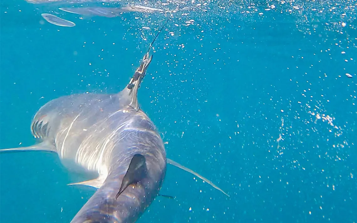
A blue shark fitted with a satellite tag on its dorsal fin gathered ocean temperature data. | Photo by Nola Schoder, University of Miami Rosenstiel School
The clock was ticking when Laura McDonnell and her team, dubbed “The Pit Crew,” reeled in 19 sharks over the course of a week off the coast of Cape Cod, Massachusetts, during the fall of 2021.
The Pit Crew had one goal: In under five minutes, they needed to secure a satellite tag on the dorsal fin of each shortfin mako or blue shark before releasing it back into the ocean. The tags then tracked the sharks until March 2022, as they migrated throughout the Northwest Atlantic, a few even reaching Florida. Some dove to 6,483 feet, recording temperatures between 39° and 93°F, transmitting data to satellites each time they surfaced. Researchers, including Ben Kirtman, used the information to fill critical gaps in climate forecasts. One study showed that forecasts incorporating shark-collected data reduced errors in surface-temperature predictions by up to 40 percent.
These forecasts help us understand the broader climate system, in which oceans play a critical role. From ecologically rich coral reefs and continental shelves to the deep sea, oceans are the world’s largest ecosystem, covering 71 percent of the planet, and are its largest carbon sink.
“I used to get phone calls at two o'clock in the morning. 'Where's your forecast?'” said Kirtman, a climate scientist and professor of atmospheric sciences at the University of Miami.
In recent years, unprevented marine heat waves are wreaking havoc across every front. Most prominently, coral reefs are experiencing mass bleaching events. “As the climate system continues to warm, I think it's evident that we're seeing more marine heat waves. That's going to put an enormous amount of stress on our ecosystems. These forecasts become critical,” Kirtman said.
Future conservation efforts need these forecasts to understand how to restore coral reefs and plan for sea level rise, tropical storms, and El Niños, when the ocean surface warms in the central and eastern tropical Pacific Ocean. On land, this results in increasing temperatures, drought, extreme weather, and rainfall patterns in certain regions of the world.
Collecting data for forecasting
Forecasts are a recipe, mixing ingredients of data and modeling, Kirtman said. Ocean data is collected through a variety of tools: satellites measuring the surface temperature, fixed buoys, and drones that flow along currents before reporting back to satellites. Each instrument has its limitations, and no forecast is perfect.
Satellites cannot measure below the surface of the ocean or read through clouds. Buoys aren’t as useful in the deep sea below 656 feet, or along continental shelves, where shallow waters give way to steep drop-offs. Both areas are notoriously difficult to measure. Buoys can also be vandalized, and drones can drift. It creates a relatively small pool of data. “There's lots of variability in the ocean,” Kirtman said.
Within climate forecasting, there are also two barriers in the system. The quality of models and the data that researchers use. The easiest fix is simply gathering more data.
Sharks as oceanographers
To collect more data, Kirtman and other researchers at the University of Miami turned to sharks. They wanted to see if they could fill data gaps from continental shelves and the deep sea to improve forecasting.
But the team needed to find species of sharks that would surface often. Data would then be transferred to satellites from a shark's most recent dive.
They chose shortfin makos (Isurus oxyrinchus) and blue sharks (Prionace glauca). “They travel far; they dive deep. We know about these species. They're going to be the best candidates,” said McDonnell, a postdoctoral investigator at the Woods Hole Oceanographic Institution. McDonnell completed the project of tagging sharks to see if they could improve forecasting as part of her PhD work at the University of Miami.
Shortfin makos are the fastest sharks on the planet, traveling at speeds of 31 miles per hour, with bursts up to 46 mph. They are commonly confused with great white sharks due to their size, reaching up to 13 feet, with long snouts, protruding teeth, and grayish-blue backs. Despite their abundance, they are listed as near threatened by the International Union for Conservation of Nature. They face global fishing pressure and are monopolized in the illegal shark-fin trade.
Blue sharks are different, named for their bright-blue backs that fade into a crisp white underbelly, forming a torpedo-shaped body. They can be as big as 13 feet but are more commonly 10 feet long, with a cone-shaped snout and large eyes. “They do target a lot of the mesoscale features that are hard to capture in climate models, like eddies. They definitely ride the Gulf Stream boundary like a roller coaster,” McDonnell said.
The team tagged sharks over two years but only used data from the first trip in fall 2021. The 18 blue sharks and one short fin mako transmitted a total of 2,635 days across the Northwest Atlantic. On average, each shark recorded 139 days. The tags are made of stainless-steel nuts and bolts, coated with an anti-biofouling paint to prevent any buildup. They eventually release, usually two years after being secured. Sometimes people also find the tags and call the researchers. After analyzing the data, Kirtman found that these sharks filled gaps in the forecast, producing them with less error, compared with data from satellites or buoys.
But more research is needed before animal-collected data can become a routine part of climate forecasting. “There's evidence that improves the forecast in some places and doesn't improve it in others. It’s not as simple as generating forecasts with this data, though. Seasonal predictions is a hard problem. You have to test it in the past for at least 30 years, maybe more. We didn't do that because we didn't have resources to do that. This was a proof of concept,” Kirtman said. Until that longer-term testing is done, researchers can’t know whether the improvements are consistent enough to incorporate data into routine seasonal forecasts.
Future efforts
This was not the first time marine animals were implemented as oceanographers. Other global studies have tagged seals and even sea turtles to predict storms and understand ocean change.
In Honolulu, research professor Kim Holland at the University of Hawai'i is currently deploying tags on a variety of shark species, including tigers and hammerheads, to measure the temperature profile of the ocean.
“I was very surprised when we got into this, as to how sparse the ocean sampling was,” Holland said, “If you [are] interested in an area like the East Coast continental shelf or the Gulf Stream … these drifters [traditional monitors] get carried away. Whereas the sharks or the turtle said, 'No, I'm not getting carried away. I want to work here for a while.' The animals are, in some ways, more reliable than the mechanical methods.” Their study also found that marine animals can increase both sampling frequency and the geographic region, reaching areas that are notoriously difficult to access.
As climate change persists, and El Niño surfaces, Holland said that he hopes this study will push future efforts with climate modeling, as the main factor holding these efforts back is lack of funding.
To dig deeper, Kirtman said, we have to continue research: “You talk six months in advance, you need to go deeper. You talk five years in advance or 10 years in advance, then you really need to go deep.… We're hoping that somebody will say, 'Let's see if we can do that for a bunch of a number of cases,’ and then we could conceivably do it in real time.”