"Smart Growth - As Seen From the Air" describes studies reported in a peer-reviewed journal article: Location efficiency: Neighborhood and socio-economic characteristics determine auto ownership and use-studies in Chicago, Los Angeles and San Francisco; John Holtzclaw, Robert Clear, Hank Dittmar, David Goldstein and Peter Haas; Transportation Planning and Technology, 2002, Vol. 25. This article is behind a journal paywall; request Fair Use copy from John.Holtzclaw@sierraclub.org or click "Read more" below.
(Presented at the Air & Waste Management Association's 93rd Annual Meeting & Exhibition, 23 June 2000, Salt Lake City, UT)
Abstract
The design of our urban areas and their transportation systems strongly influences emissions of urban air pollutants. Smart Growth can increase neighborhood convenience, consequently reducing driving to one-fourth or less, by:
- increasing neighborhood density to raise the number of nearby destinations,
- including markets, restaurants and other commerce and services in residential neighborhoods (mixed-use),
- locating neighborhoods close to job centers,
- providing safe, attractive and convenient pedestrian and bicycle conditions,
- limiting parking, and
- providing frequent, convenient, affordable and safe public transit.
Such neighborhoods encourage walking, bicycling and use of transit for most trips. Equations developed from research using all these variables except parking in the Chicago, Los Angeles and San Francisco regions predicts 79 to 96% of the variance in auto ownership and 80 to 94% of the variance in driving (vehicle miles traveled -- VMT) for neighborhoods within those regions. Residential density is the most effective urban variable in predicting auto ownership and driving. The next most effective variable is the amount of nearby public transit. Finally comes pedestrian and bicycle friendliness, including the fineness of the street grid, provision of public sidewalks and weather protection, location of buildings close to the sidewalk rather than behind parking lots, and traffic safety. Center proximity slightly improved the prediction of VMT in the San Francisco area, the only area where data was available. We had no measure of the amount of private and public parking by neighborhood. The success of these neighborhoods in attracting and retaining residents also depends upon:
- nearby parks, creeks, recreation areas, and other open spaces and wildlife habitat,
- attractive, quality architecture of the neighborhood and buildings,
- quality construction, built to last much longer than housing or shopping centers located in sprawl.
Read more...
The study showed the annual household driving for the San Francisco Bay Area neighorhoods, shown in the map below. Note that households in the highest density areas only have to drive around 2 - 5% as much as residents of the lowest density sprawl. Note also that you can trace the routes of Caltrain and BART by the reductions in driving.
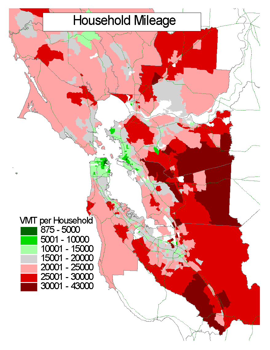
Annual Household Driving – San Francisco
Chicago's downtown reflected in the Millennium "Bean"