Can We Predict Wildfires?
Researchers are coming up with a host of new tools to anticipate where the next mega-burn will occur
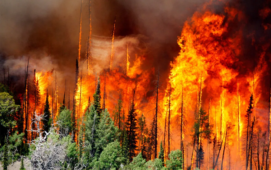
The Brian Head Fire burned more than 70,000 acres in 2017 in Brian Head, Utah. | Photo by Stuart Johnson/The Deseret News via AP
There’s a reason why megafires are the new normal across the Western United States. Human-caused climate change, which has resulted in drier conditions and hotter temperatures, along with a long history of fire suppression, has turned much of the region into a tinder box. In 2024, according to some analyses, wildfires increased by 14 percent from the previous year, totalling 64,897 wildfires in the United States.
Some recent megafires—burns that scorch roughly 100,000 acres—include Arizona’s 145,000-acre Dragon Bravo Fire, California’s 131,000-acre Gifford Fire, Oregon’s 95,000-acre Cram Fire.
Researchers look at three different elements when considering the breadth and intensity of a fire: fuel, weather, and ignition. While the first two can be tracked using climate analysis, ignition is the tricky one. The National Park Service reported that from 2000 to 2017, nearly 85 percent of wildfires in the United States were started by humans. The National Interagency Fire Center quantified the total human-caused fires in 2024 to 57,962 sparked nationwide.
However, new technologies and updated understandings of burnings are starting to help researchers anticipate even the human element of wildfire. Spanning different regions, wildfire tracking is now being customized to local needs. Some of these revelations have the potential to change the nature of how scientists anticipate future burns, especially large ones.
“We don’t know tree to tree, but we can look at a macro scale, and then the same thing over longer time scales, 10, 20, 30 years,” said John Abatzoglou, a professor of climatology at the University of California, Merced.
Currently, scientists predict wildlife using satellites to track temperature, precipitation, expected winds, and humidity. On the ground, real-time monitors or weather stations collect data from airports, park services, or areas where they are a part of a larger network. These stations connect to satellites that capture high-frequency, low-resolution images. Grace Kim, a data consultant and former researcher at NASA’s Goddard Space Flight Center, said this data feeds into algorithms that give scientists an idea of what to expect with each wildfire.
While widespread, this technology is inefficient due to its limitations in detection. This can include environmental factors like dense vegetation, smoke, or clouds that obscure detection accuracy. Technological limits and availability can also result in false positives, data gaps, and scattered signals.
Can Scientists Predict Wildfires?
Abatzoglou said that by looking at the larger picture, scientists can make assumptions about fire level risk, using “patterns that we can draw upon,” despite some of these limitations. For example, one factor includes how people use the land—such as for recreation—and population density, which correlates with human ignitions.
He also said it’s important to consider certain “cultural fingerprints.” Weekends and the Fourth of July holiday are typically times when human-caused fires increase. Overlaying those patterns with other factors, such as the availability of fuels, can help researchers anticipate when fires might occur.
“Humans are less predictable than the environment in general,” he said. “But if we can rely a little bit on past patterns and then known elements of how dry fuels need to be for them to be ignited, that can give us a relatively good idea.”
At the US Forest Service Fire Sciences Laboratory in Missoula, Montana, Mark Finney, a senior scientist and research forester, leads multiple research teams that study wildfire behavior. Among their duties is recreating contained fires under various conditions.
For instance, they’ve used a burn table to mimic the vertical landscape of wildfires, studying how slope, and moving air can change specific wildfire characteristics in mountainside fires. They’ve also used a tall cylinder chamber to create vertical fires, called “firenados,” so that they can better understand how winds exacerbate wildfire destruction. And in a converted grain silo, the team has studied combustion and the duration of fires fed by large woody fuels.
“Wildland fire is not necessarily going to be solved by technology,” he said. “It’s going to be solved by using fire and getting along with our environment, rather than just subduing it.”
Nick Bond, Washington state’s climatologist from 2010 through 2024, also looks to nature when considering wildfires. He pointed out specific trends he’s noticed over the last decade, including warmer temperatures, especially at night, which he said can keep a fire more active if the temperature remains high. Even in places like the Pacific Northwest, he said, drier and longer summer seasons can make for dangerous conditions once windstorms come along.
Wildfire Tracking in Real Time
Kyle Bocinsky, a researcher and computational archeologist at the University of Montana, has spent his career examining the impacts of climate change and possible resources for adaptation on tribal reservations. As a part of his work, he’s developed software to collect data on drought and wildfire conditions when looking at climate change locally. Bocinsky said that while many of the variables that make up a wildfire can change, season to season, the overall intensity is increasing. As the director of Climate Extensions for the Montana Climate Office at the University of Montana, he works with a team of researchers to monitor wildfire smoke by providing technical expertise to less-resourced communities in Montana.
Since he started this work in 2018, his office has created a Drought Dashboard to assess weekly drought conditions across the Upper Missouri River and Columbia River Basins. Along with the Confederated Salish and Kootenai Tribes, his team has installed 40 Purple Air low-cost weather sensors across the Flathead Reservation. The program has become the primary and official resource for drought and climate information for the state and is a part of a five-state consortium that is currently building a weather observing network in the upper Missouri River Basin.
The Forest Service has also developed a free website for communities to assess their specific wildfire risk. Searching by zipcode, residents can view interactive maps for their local area and learn about ways to reduce risk and stay prepared. Meanwhile, some communities are looking to artificial intelligence to buy themselves more time when detecting wildfires.
The state of California is using AI sensor technology for early detection, relying on odor rather than sight. It works by collecting data and sending it to a digital cloud. On the back end, the company runs an algorithm to determine what type of smoke is being detected.
Debra Deininger, the chief revenue officer at N5 Sensors Inc., a company that specializes in sensing technology, said that the devices her company makes can analyze about 30 types of data when smoke is detected. This includes particulate matter, gas, temperature, humidity, and wind. So far, the sensors have had a false-positive rate of less than one percent, and researchers at the company are currently working to predict fire locations based on wind.
“You could think of it as an electronic nose,” Deininger said. “It’s sitting there, it’s bringing all of the smoke in. It’s analyzing the chemical signature of the smoke, the size, and the amount of the particulates. And to this sensor, a regional fire that is 50 miles away smells a little bit different than a local fire, which smells different than a barbecue.”
The sensing model is currently being used in 12 states, a few provinces in Canada, and southern Europe. The researchers have some pilots in South America and were recently invited to South Korea. Together with satellites, Deininger believes that ground-based smoke sensors can create a layered system of wildfire detection.
Seth Schalet, who sells both N5 Sensors and satellite technology for wildfire detection, said this information is stored and can help other locations in the network. So far, 75 sensors have been installed in Santa Clara County, and 15 more will be installed in December. By the end of 2026, he estimates to have 110 sensors installed in the region.
Bond, the climatologist, agrees with the growing consensus that an extended wildfire season is the West’s new normal. “They’re here to stay,” said Bond, of the growing fire season. His recommendation on living alongside wildfires? “Continue making progress toward dealing with them.”