Inherit the Dust
The Colorado River is running out of water. No place will be more affected than the arid metropolis of Phoenix.

A subdivision in the arid metropolis of Phoenix.
Not far from the constant roar of Phoenix’s Sky Harbor Airport and just a few miles from the massive, air-conditioned stadium of the Arizona Diamondbacks baseball team lies what might be the quietest enclave in the United States’ fastest-growing city. Pueblo Grande, the “big house,” was settled around AD 450 and for close to 1,000 years was continuously inhabited by the Hohokam people. Home to hundreds of families at any one time, Pueblo Grande was but a single outpost in a sprawling, thriving civilization of as many as 300,000 people at its height. While the Roman Empire was falling into decay, the Hohokam culture was building one of the greatest cities in what would eventually be called the Americas.
The key to the Hohokam’s success in the blistering climate of the Sonoran Desert was a complex network of canals that, at its zenith, was some 500 miles in length, crisscrossing what is now affectionately referred to as the Valley of the Sun. The canals diverted water from the Salt River to irrigate the Hohokam’s fields of maize, melons, squash, and beans. No other ancient civilization in the Americas—not even the Inca or the Maya—built a more extensive water conveyance system. Nineteenth- and early-20th-century white settlers marveled at the perfect design of the canals, which, in the words of one observer, were “an engineering triumph.”
Today, all that remain of the Hohokam big house are a smattering of mounds, earthen walls, and the outlines of small rooms that served as living quarters, granaries, and perhaps ceremonial centers. Along one side of the site runs a small trickle of water, slick with languid green strands of algae. This concrete-lined channel, known as the Old Crosscut, is one of hundreds of canals built by white farmers who settled the region in the late 1800s and who also grew melons and squash in the desert. In some cases, they grafted their ditch over the outline of an ancient canal—a modern civilization building upon the foundations of a past one.
No one knows exactly why, in the 14th century, the Hohokam abandoned Pueblo Grande and other settlements across the Salt River Valley. Two hypotheses (perhaps not mutually exclusive) are that the Hohokam were laid low by prolonged drought and that hundreds of years of relentless irrigation salinized the soil, which in turn led to a collapse in agriculture. “In either case, the mysterious disappearance of Hohokam civilization seems linked to water,” Marc Reisner wrote in his masterwork Cadillac Desert. “They either had too little or used too much.”
The secret of the culture’s disappearance from the region may be encapsulated in its name. Hohokam derives from a word in the language of the Akimel O’odham, a contemporary Native nation. It means “all used up” or “exhausted.”
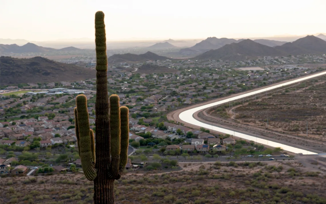
The 336-mile-long Central Arizona Canal delivers a third of Arizona’s water from the Colorado River to the state’s cities and farms.
THE QUIET POIGNANCY of Pueblo Grande is a striking contrast to the gleam and frenetic hum of modern Phoenix. In 1950, the Arizona capital was little more than a large town, home to roughly 100,000 residents scattered across 17 square miles.
Today, Pueblo Grande lies at the heart of a sprawling 15,000-square-mile megalopolis with some 4.9 million residents, which for the better part of half a century has been among the fastest-growing metropolitan regions in the United States.
Like the previous civilization over which it is built, Phoenix must rely on maintaining control of that most precious and fleeting of desert resources: water.
The first major step in the modern effort to water the desert came in the early 1900s with the construction of the Salt River Project. Built under the auspices of the National Reclamation Act, the SRP saddled the region’s largest river with four major reservoirs and 130 miles of canals. Yet even with the new infrastructure intended to “reclaim” the desert, cities and farmers were ultimately limited by the same modest water sources that had sustained the Hohokam centuries before.
That all changed in 1922, with the signing of the Colorado River Compact. This master document provided a framework to divide the Colorado River’s water among seven western states and promised a massive new supply of water to Arizona—though it would take more than 70 years of political and legal wrangling to get it flowing. In 1973, construction began on the Central Arizona Project, or CAP, a massive system of reservoirs, pumping stations, and aqueducts that would shuttle water 336 miles across the desert from Lake Havasu to Phoenix.
The completion of the CAP in 1994 accelerated the Phoenix area’s explosive growth. Already a sprawling metropolis, Phoenix and its suburbs spread even farther, as tangles of subdivisions and big-box stores materialized across vast tracts of desert. Many of the new neighborhoods (Hohokam Hills, Apache Peak, Anasazi Village) paid lip service to the region’s original inhabitants while adhering to none of the principles that allowed those cultures to survive there for centuries. Golf courses and megaresorts resplendent with green grass materialized in terrain naturally suited to mesquite and saguaro. Despite the infernal summer temperatures, the modern desert dwellers could live in climate-controlled comfort, cooled 24-7 with air conditioners powered by the Palo Verde Generating Station, the biggest nuclear generator in the world that is not located on a body of water.
It was not cities, however, but agriculture—notably the “big c’s” of cotton, citrus, and cattle—that took greatest advantage of the new water supply. Today, agriculture in Arizona consumes 74 percent of the state’s water supply. And it’s not just local entities that are competing for the increasingly scarce water. Fondomonte, a Saudi Arabian agricultural firm, has rented a 3,500-acre plot of state-owned land at a steeply discounted rate to grow feed for cattle in Saudi Arabia. To grow its crop, Fondomonte is slurping up as much as 18,000 acre-feet per year—enough water to supply 54,000 homes.
The runaway agricultural and urban growth in the Phoenix metro area and across the state runs parallel to another story that is defining the West: the diminishment of the Colorado River. The river’s natural average flow at Lees Ferry (downstream from Glen Canyon Dam) declined from around 12 million acre-feet in 1900 to a forecast 6.5 million acre-feet in 2022. The reasons the river is shrinking are many, from the climate-change-related declining snowpack in the Rocky Mountains to the rising demand from rapidly growing cities such as Denver and Salt Lake City.
Last year, the river’s diminution reached a crisis point hydrologists have been warning of for decades. Wracked by more than 20 years of drought, the two largest reservoirs along the Colorado River—Lake Powell and Lake Mead—dropped to their lowest levels in history. In April, Lake Mead fell below the level of the reservoir’s water intakes, which send water to pipelines feeding Las Vegas and other communities in southern Nevada. In May, as water levels dipped even further, a barrel containing a human corpse turned up on the reservoir’s retreating shoreline.
Though the drying of the Colorado River is dire for states across the West, the consequences are most severe for Arizona. Under the rules of the Colorado River Compact, Arizona’s water rights are the most junior in the Colorado River Basin. This means that it is first in line to have its allocations cut during a shortage.
In August 2021, Lake Mead fell to 1,075 feet, a critical threshold that prompted the Department of the Interior to declare a water shortage for the first time in the river’s history. Deliveries to the Central Arizona Project were cut by a volume of 512,000 acre-feet, roughly 8 percent of the state’s total annual water use. The state’s farmers were the most affected. “The story is actually pretty simple,” Will Thelander, a third-generation farmer, told the Arizona Republic the week the cuts were announced. “River was over-allocated, too much growth, huge drought, not enough water. You got to start cutting it off somewhere.” In August 2022, the federal government went further and slashed Arizona’s 2023 water allocation by 21 percent.
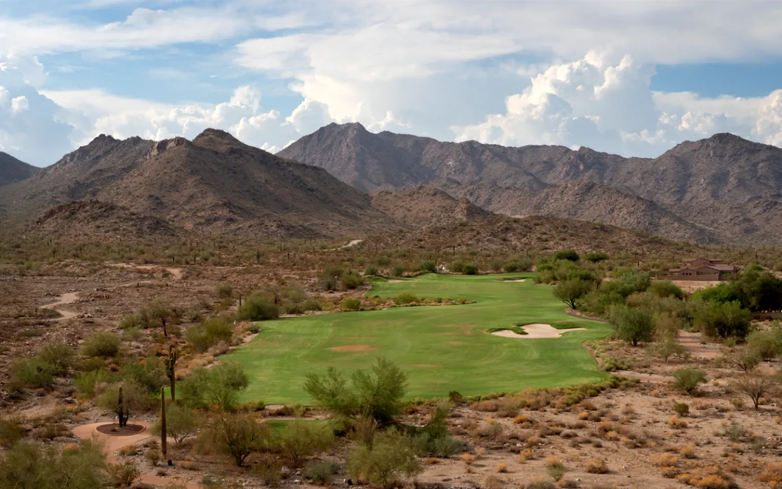
In metro Phoenix, golf courses and megaresorts have materialized on terrain better suited to saguaro and mesquite.
A moment of hydraulic reckoning has come for Arizona and its largest metropolitan area. But even as a new era of water scarcity looms over the state, local leaders continue to preach the gospel of endless growth. “No one even wants to mention that Arizona might have a water problem,” Sierra Club Grand Canyon Chapter director Sandy Bahr said, “because to admit that would be ‘bad for business.’ ” Even as the Colorado River dries up, the boom shows no signs of abating. Phoenix and the adjacent city of Mesa (population 504,000) remain among the most competitive real estate markets in America. At current rates of growth, the population of Phoenix’s metro area is expected to include another 2.1 million people by 2040.
By most measures, the present drought in the greater Southwest is entering its 22nd year. Some researchers and policy experts have started to question whether drought is even the right word to describe what is unfolding and instead prefer the terms megadrought and aridification. It is likely that the southwestern United States is on the front end of a long-term shift in climate, a region-wide drying out that is driven in large part by human-made carbon pollution.
The hydraulic reckoning is forcing hard questions that the state’s political leaders have always procrastinated in addressing. Can the region’s agricultural and urban sectors continue their rapid expansion as the Colorado River withers? Or is it a slow-motion disaster, a situation the late Arizona representative Morris Udall envisioned as “a return to desert, to dust”?
ABOUT 20 MILES north of central Phoenix, a concrete river slices through the desert and past craggy peaks. This artificial waterway, the Central Arizona Canal, carries more than one-third of the state’s water supply from the main stem of the Colorado River to the desert metropolis and the farms that surround it. The Central Arizona Project is the largest and most expensive aqueduct system ever built in the United States, and it’s no exaggeration to say that without this vital artery and its massive transfusion of water, modern Phoenix would not exist at its current size and scope.
A few hundred yards from the canal are the low-rise headquarters of the CAP. In this rather nondescript building, I met with Vineetha Kartha, the CAP’s Colorado River program manager, who oversees “planning and strategy” for the vast irrigation project. Kartha spent her early years living on oceangoing ships with her father, who worked as the chief engineer on oil tankers and freighters. Among her most powerful memories is the wonder she felt when passing through the Suez and Panama Canals as a child. “I guess I’ve always had a thing for canals,” Kartha said with a laugh, explaining that she sees her job as akin to piloting a freighter through the Panama Canal: “I have to steer my ship through that canal, within the boundaries that are set by the law of the river.”
The keystone of that so-called law of the river is the Colorado River Compact. When the interstate delegation of leaders, water managers, and real estate developers from Colorado, Utah, Wyoming, New Mexico, Nevada, Arizona, and California sat down to draft the compact in 1922, their first step was to reach an agreement on how much water the Colorado River carried. Relying heavily on data in a report compiled by hydrologist Arthur Powell Davis and Interior Secretary Albert Fall, the group arrived at a final figure of 18 million acre-feet of water annually. That volume was to be divided evenly among the states of the upper basin (New Mexico, Colorado, Utah, and Wyoming) and the lower basin (Nevada, Arizona, and California).
In the 100 years since, many researchers have questioned the scientific rationale and political machinations behind the 18 million acre-feet figure. Whether the decision was accidental or the product of an opportunistic myopia is uncertain. What is clear is that when the compact was drafted, the American West was in one of its wettest periods in more than 1,300 years. The architects of the Colorado River Compact consented to a number that Mother Nature simply could not fulfill.
Those historic miscalculations are weighing heavily on the present management of the river and making Kartha’s job increasingly difficult. The current “Tier 1” cuts triggered by the drop in water levels at Lake Mead fall almost entirely on Arizona, specifically its farmers, who collectively use more than two-thirds of the water delivered via the CAP aqueduct system. If Lake Mead continues its precipitous decline, new, more far-reaching reductions will be enacted. “As the drought gets worse, more and more people will be affected,” Kartha said. At Tiers 2 and 3, she explained, municipal and industrial water users will experience reductions, as will the Native American nations that collectively hold rights to roughly a quarter of Arizona’s Colorado River allotment. “We need to figure out how to resolve this supply and demand imbalance.”
An ardent technocrat, Kartha said she sees the dwindling Colorado not as an existential threat but as a situation demanding a host of technical solutions. She pointed to measures put in place in 2007 to more carefully coordinate water releases in Lake Powell and Lake Mead and enhance storage mechanisms, which she said have made the system more responsive and resilient to drought. On the supply side, Kartha said, new desalination plants along the Gulf of California and cloud seeding in the Rockies could help mitigate further reductions in water supplies. (Others have proposed more audacious plans, such as piping water in from the Mississippi River.) On the demand side, she mentioned efforts to incentivize conservation, including so-called toilet-to-tap schemes, which use recycled wastewater for drinking water. “The power of the human mind is incredible,” she said. “We can use our brains to work through the current times.”
Kartha soon had to take her leave, and I was left in the company of CAP spokesperson DeEtte Person, who escorted me down a long hallway covered with framed images of each major piece of infrastructure in the CAP system. We arrived at a conference room that she referred to as CAP’s “nerve center.” It was not immediately clear what made this room special. The secret, it turned out, lay behind three large glass windows covered in wooden shutters. Person picked up a telephone and asked the person on the other end of the line if she could “give a reporter a glimpse inside.” Because the room is considered a piece of “critical infrastructure,” Person said I could not take pictures.
There came a mechanical whirring as the shutters began to rise. Beyond was a room filled with an array of blinking lights and glowing computer screens. Two men dressed in jeans and T-shirts watched a bank of monitors. On the wall before them was a large, flickering schematic map of the CAP system. The whole network of dams, pumping stations, canals, and floodgates can be controlled from this one room. The place conjured images of a miniature NORAD or the bridge of the starship Enterprise bedecked with wall-to-wall carpeting.
The entirety of the CAP network is remotely operated, Person explained, allowing decisions to be made in real time, somewhat like an extremely huge and complex sprinkler system. “Say there’s an unexpected rainstorm and a farmer doesn’t need his full allocation of water for that day,” Person said. “That farmer can simply call us up, and we can change his irrigation schedule. We can track everything, all from right here.”
CAP’s nerve center is impressive—evidence, of a sort, of what Kartha called “the power of the human mind.” In the control room, you can witness how human ingenuity has remade the desert. But is it truly control? Or the mere imagining of it? The CAP network, after all, is tied to a natural system beyond human command. And that system, scientists caution, seems to be breaking down.
FOR THE PAST 30 years, Connie Woodhouse, a geography professor at the University of Arizona, and her colleague, paleohydrologist David Meko, have been trying to figure out how drought factors into the natural climate cycles of the Southwest. On a 95-degree day in late April, she and Meko sat in her darkened office, located on the top floor of the Bannister Tree-Ring Building. It is the largest repository of tree ring samples in the world, and with its thin vertical columns and curved glass windows, Woodhouse explained, the building is designed to resemble a futuristic treehouse. Tens of thousands of pieces of wood are housed inside its vast archives—each a small chapter in the sprawling narrative of the planet’s climate.
Woodhouse, along with former University of Arizona professor Jonathan Overpeck, is credited with coining the word megadrought. She admitted, however, that she doesn’t much care for the term, which she feels has become something of a hollow buzzword. “It’s used a lot without defining what it means,” she said, “and with little precision in terms of duration.”
Woodhouse retrieved a cross section of wood from a bookshelf behind her desk. This one was a slice of ancient bristlecone pine that she’d collected several years ago high in the Colorado Rockies. Bristlecones are among the oldest living organisms on Earth. They are also extremely slow growing, in some cases adding only an inch of diameter per century. Their longevity provides an invaluable snapshot of climate. Woodhouse pointed to one section of rings more widely spaced than the rest. This indicated a series of years in which the tree received above-average moisture. Then she pointed to an area in which the rings were hardly separated from one another. “This is a dry period,” Woodhouse said. In the driest periods, several years of growth rings are so tightly packed together that the rings run together in wide, dark bands. By collecting wood samples from long-lived conifers along the Colorado River, Woodhouse and Meko have constructed a long-term record of streamflow on the Colorado River system dating to AD 762.
When Woodhouse and Meko published their first comprehensive streamflow reconstruction of the Colorado River in 2007, they found that the current dry period (then in its seventh year) was not as prolonged or severe as droughts that had struck the basin in the 1100s and 1200s. But the situation has worsened drastically since that analysis 15 years ago. Last year, Meko was invited to a water conference in western Colorado to talk about the current drought and how it compares with those in the past. To figure that out, he looked back at the 2007 study along with another undertaken in 2018. Then Meko projected forward, assuming the dry period would continue at least through 2024. The results shocked him. “In that scenario, the current drought is more severe than any we saw in our previous reconstructions.”
In other words, if there were a megadrought in the Colorado River Basin in the past 13 centuries, we are currently in the middle of it. “The CAP can be optimistic, but the problem, as you can read every day in the paper, is that Powell and Mead are being drawn down,” Woodhouse said. “The Colorado River has much less water in it because of this historic drought. How are you going to engineer your way out of that?”
THE LIKELIHOOD OF long-term aridification and megadrought has prompted some of the region’s leaders to contemplate what was once considered unthinkable: the renegotiation of the 100-year-old Colorado River Compact. In May, Bruce Babbitt, a former Arizona governor and a secretary of the interior during the Clinton administration, called for that very thing. “While I once thought that these aridification scenarios were kind of abstract and way out in the future, I don’t think that anymore,” Babbitt told the Los Angeles Times. “It’s absolutely urgent that we start thinking now, while there’s time, about how we adjust the compact, the regulations, the necessary reductions, in the most careful way so that we limit the damage, which can really be extreme.”
Others, though, believe renegotiating the compact is a nearly impossible task. “If we look at the compact today and ask ourselves, Was it equitable given 2022 values? No, it wasn’t,” said Anne Castle, a former Interior Department official in the Obama administration, during a speech at the University of Utah in March. “But part of the reason I say that I wouldn’t suggest a renegotiation is because I don’t think it’s politically possible.” That’s because the compact requires cooperation among the states before Congress can alter the terms of the agreement. Any renegotiations would require the consent of leaders in upper basin states, many of whom are pushing to utilize a greater share of their Colorado River entitlements. Those aspirations are embodied in projects such as the proposed Lake Powell Pipeline, which would deliver water from the receding reservoir to fuel the growth of St. George, in southwestern Utah.
In the absence of any real hope of securing more Colorado River water, Arizona is doing what most water users in the West do when drought hits: pumping more water from the ground.
For decades, farms and cities in Arizona tapped local aquifers with abandon. That unchecked siphoning caused mass subsidence across the region. In the 1970s, surveyors found that a 625-mile area around the farming town of Eloy had sunk by as much as 12 feet. In some places, massive fissures formed in the earth, a process that continues today. Collapsed aquifers not only threaten roads, buildings, and other pieces of infrastructure (notably irrigation canals, including those of the CAP itself) but also prevent water from being pumped back into the ground for storage.
In 1980, the Arizona legislature passed the Groundwater Management Act, or GMA, to curb the rapid depletion of aquifers. The act required farms and cities in specifically defined “active management areas” to balance their groundwater use by 2025. The GMA was a step in the right direction, said Kathy Ferris, a senior research fellow at the Kyl Center for Water Policy at Arizona State University and one of the main authors of the act. “We were trying to get our act together,” she said. “And it looked like we finally would.”
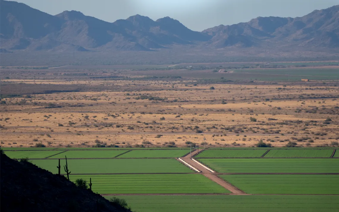
Agriculture, like these fields of alfalfa grown for cattle feed, uses nearly three-quarters of Arizona’s limited water supply.
But recent efforts to conserve water and replenish aquifers in Phoenix and other municipalities—by eliminating lawns, for example, and requiring high-efficiency appliances—are being overwhelmed by blistering growth in outlying communities. Ferris mentioned the city of Buckeye, which has grown from a mere 6,500 people in 2000 to close to 100,000 today. The problem is not merely Buckeye’s frenetic growth but the fact that the city, like many of the state’s rapidly expanding communities, has no access to surface water and is entirely dependent on groundwater.
It wasn’t supposed to be this way, Ferris said. In 1993, the Arizona legislature required developers to prove that their new developments would have a 100-year “assured water supply”—a “safe yield” that state water managers hoped would foster more sustainable patterns of development. Builders hell-bent on covering the desert with tracts of houses soon found a loophole in the law. Rather than building single large subdivisions with hundreds of homes, developers instead built many small, scattered groups of houses, so-called wildcat developments. This tactic allowed developers to evade the 100-year water requirements of the GMA, since those rules apply only to homes built in subdivisions.
The community of Rio Verde Foothills, located in the desert northeast of Phoenix’s neighbor, Scottsdale, is one example of a development built this way—and it offers a troubling glimpse of the future for tens of thousands of residents living in other wildcat developments statewide. Earlier this year, after the shortage in Lake Mead was announced, Scottsdale officials notified Rio Verde Foothills residents that the city would no longer truck water into Rio Verde Foothills and residents would need to secure a new water source by the end of the year. To make ends meet, some have come to rely on friends and family bringing water in jugs. Others have found temporary salvation by hiring fly-by-night water haulers who in recent years have been accused of illegally siphoning water from fire hydrants in the Phoenix metro area.
“We can’t conserve our way into safe yield anymore,” Ferris told me. “We have too much growth, and we have too much residual groundwater pumping.” She noted that the GMA grandfathered many agricultural users, allowing them to pump “in perpetuity.” “We have also granted new users to use groundwater. We keep adding to the load, to the stress on our groundwater supplies, and we are not subtracting from it at the moment.”
“In order to begin to solve that problem, you have to start doing stuff right now,” said Grady Gammage Jr., a noted water policy expert at Arizona State University and an attorney who often represents developers. Gammage estimates that the Phoenix metro area has enough water to keep growing at its current rate for between 25 and 40 years—even factoring in water cuts and climate change. Gammage also believes that the water that has been artificially banked will last another 15 to 30 years. “But that’s like a savings account. Once it’s gone, it’s gone.”
While his growth projections seem rosy given the severity of the water crisis on the Colorado River, they come with one hard-nosed caveat: the near-total elimination of all farming in central Arizona. “That’s the big issue we’re going to have to face,” he said. “If we’re going to continue to have urban growth, we can’t have farming at anything like the level we’ve had in the past.”
ON A WINDY late-April afternoon, Nancy Caywood led a small group of visitors on a tour of her farm. Her family has grown cotton on the 255-acre plot outside Casa Grande, about 60 miles south of downtown Phoenix, since the 1930s. But there was no sign of the farm’s signature crop. The fields were sere, blank, furrowed like corduroy, and devoid of vegetation save for a few weeds along the margins.
Heavy gusts threw dust into the air and snapped the limbs of a towering mesquite tree. Caywood walked over a parched expanse of caliche—soil turned concrete-hard by the elements—pausing occasionally to explain the array of sandblasted machinery scattered about the yard. Soon the wind and dust became too much to bear, so the group retreated to a small trailer adorned with folksy baubles—baskets, hand-painted saws, Christmas wreaths made of raw cotton.
Inside, Caywood turned on a laptop and projected a PowerPoint presentation onto a screen. The farm, she explained, at one point grew a variety of cotton called pima, which is adapted to heat and dry climates. Now it’s too dry here for even pima to thrive, and the farm grows an upland variety of cotton. She proudly proclaimed pima to be one of the finest cottons in the world. To illustrate, she handed everyone a boll, which she urged us to pull apart. She said the cotton had been genetically modified to withstand heavy doses of pesticides applied to keep bollworms in check.
Soon the presentation came to its crux—which wasn’t cotton-ravaging pests but water. Caywood said her family would be receiving a mere 5 percent of its water allotment this year. (Since that tour, the farm’s water allotment has shrunk to zero.) The farm, she explained, does not receive water from the CAP but from the Gila River, Arizona’s largest tributary of the Colorado. The Gila’s San Carlos Reservoir was at less than 3 percent of capacity. Caywood flashed through pictures of dry canals, receding reservoirs, and parched fields and said the current drought along the Gila has been even more persistent than the one ravaging the rest of the Colorado River Basin. “The last wet year we had here was 1993,” she said. “It’s been a very long time.”
Outside, the sky filled with dust and turned a brownish red, the color of ash. Suddenly, she took on a more combative and boosterish tone. “Unless you came here naked and starving, you are part of our agriculture system,” she said. Then she handed out an assortment of popcorn, processed meat sticks, candies, and the grand prize, Hostess Twinkies. Her guests laughed giddily as she tossed the bullet-shaped pastries across the room.
“Any ideas about what these foods have in common?” Caywood asked.
One of the visitors chanced a guess: “Cotton?”
“Yes!” she replied. “All these foods are made with cottonseed oil.”
She built to her conclusion: “Cotton is in your clothes, and it’s in your food. It’s in every part of your life.”
Caywood opened the floor to questions. Those in attendance were not pesky environmentalists but people like her who work the land, albeit in wetter parts of the country that are more hospitable to agriculture. A dairy farmer from Ithaca, New York, questioned the wisdom of the entire enterprise. “Look out the window—hello, it’s a desert,” he said. “Is it smart to grow cotton in a desert?”
Another visitor, a hobby farmer from Wisconsin who sported a Sierra Club backpack, mentioned the heating of the planet. “Things are changing,” he said. “It’s getting hotter and drier. Do you think climate change has anything to do with your water shortages?”
Caywood balked. “I believe climate change is at play,” she said. “I also think naturally occurring drought is cyclical.”
The Wisconsin visitor pressed on: “But if the drought continues like it has, can you keep growing cotton?”
The wind clattered the roof and rattled the walls.
“We don’t plan to quit farming out here anytime soon.”
This article appeared in the Fall quarterly edition with the headline "Inherit the Dust."