This Is One of the Most Ambitious Nature-Based Solutions to Sea Level Rise
The South Bay Salt Pond Restoration Project is restoring wetlands in the Bay Area
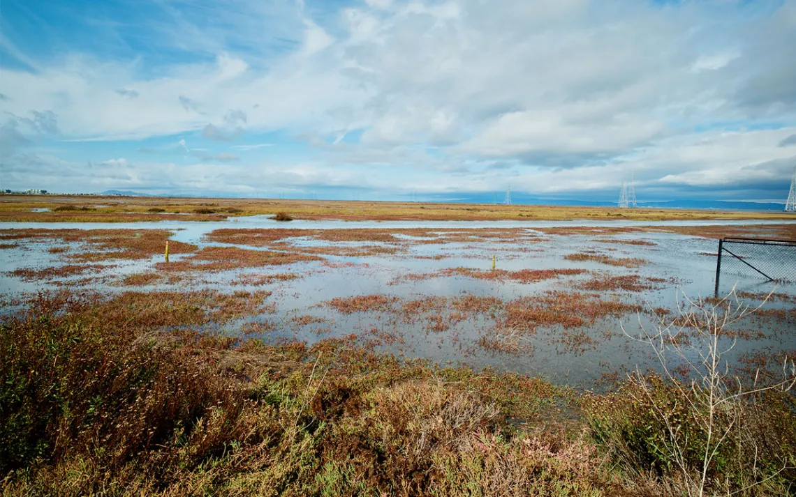
Photo by Jeremy Miller
Dave Halsing stood beneath shifting clouds and flocks of shorebirds next to California’s San Francisco Bay, looking out at the gray waters below. Beyond us, traces of sunlight flickered on the arc of the Dumbarton Bridge.
Halsing is the executive project manager of the South Bay Salt Ponds Restoration Project. He invited me to the Ravenswood section of Menlo Park on a windy November day to see a small piece of the massive, puzzle-like initiative he has been involved with for the past seven years. He unlocked a gate, then we climbed into his car and drove onto an earthen levee. This parcel, which includes a section of Don Edwards National Wildlife Refuge, teemed with birdlife. Cormorants bobbed among whitecaps. On a small island, a flock of white pelicans huddled against the wind.
To the untrained eye, the South Bay Salt Pond Restoration Project is easy to miss. During our visit, which coincided with a king tide, the ecological rejuvenation it has catalyzed was almost completely hidden underwater. Below the surface was the most ambitious wetland restoration project on the entire West Coast.
The project originated in late 2002, when Senator Dianne Feinstein, Governor Gray Davis, and Interior Secretary Gale Norton reached an agreement with the salt ponds’ owner, the agribusiness giant Cargill, to purchase 16,500 acres for $100 million. The federal and state acquisition of the ponds was seen as a monumental win for increasing public shoreline access and endangered species habitat. In recent years, the effort has also come to be viewed as a critical defense against sea level rise in the San Francisco Bay Area. The South Bay Salt Pond Restoration Project specializes in nature-based solutions, re-creating large buffer zones of tidal estuary to protect the region instead of using more traditional “gray” engineering schemes like concrete seawalls and breakwaters.
Based on one projection from the California Ocean Protection Council, Bay Area sea levels may rise by three to six feet by the end of the century, threatening millions of residents and billions of dollars in infrastructure. Water levels here are rising at roughly two millimeters per year, and the consequences are already visible. Tidal flooding regularly swamps Highway 37, a key corridor connecting several counties.
The South Bay salt pond restoration represents a rare chance to get ahead of rising seas. So far, just over 3,700 acres of the ponds purchased in 2003 have been restored. The goal, Halsing explained, is to transform 15,000 acres—an area roughly the size of Manhattan—of former salt ponds into tidal wetlands. It’s a turning back of the ecological clock: The ponds were carved out of marshes to make salt starting in the mid-1800s and soon became a dominant feature of the bay, visible from space.
“The bay is cleaner if you have more marshes, and they provide all these [human] benefits like flood protection,” Halsing said.
The South Bay restoration hinges largely on a single design feature: massive earthworks called horizontal levees, or ecotones. Unlike typical steep-sided levees, these gentle berms are being built as long, sloping ramps, designed to mimic the vast tidal flats that once extended miles into the bay. When complete, they will provide thousands of acres of new wildlife habitat for hundreds of species, including endangered mammals and birds such as the salt marsh harvest mouse, Ridgway’s rail, and California least tern.
Creating these earthworks requires staggering volumes of dirt. Roughly 400,000 cubic yards of fill have been hauled to the site, about 38,000 truckloads between 2019 and 2024. Nearly all of it came from construction sites.
For a preview of the future, we climbed a rise in nearby Bedwell Bayfront Park. The “hill” is a former landfill mound and the highest point in the area. To the north, we could see Greco Island, cut through with tidal channels and covered in wetland grasses in a fall palette of oranges, greens, and browns. “That marsh has been there 100 years,” Halsing said.
Greco Island’s 817 acres offer a rare glimpse of the South Bay’s preindustrial tidal marshes—and stand in stark contrast to the ecological present. A tidal slough separates it from a large pond known as R4. In 2023, R4 was reconnected to the bay with a horizontal levee. If all goes to plan, Halsing said, Pond R4 and other restored areas will look just like Greco Island.
“It won’t be adequate in five decades unless somebody comes in and does more,” Halsing said. “But we’re providing time for that to happen.”