These Inuit Maps Are Reimagining the Arctic
Counter-mapping projects are supporting Indigenous sovereignty in a shifting landscape
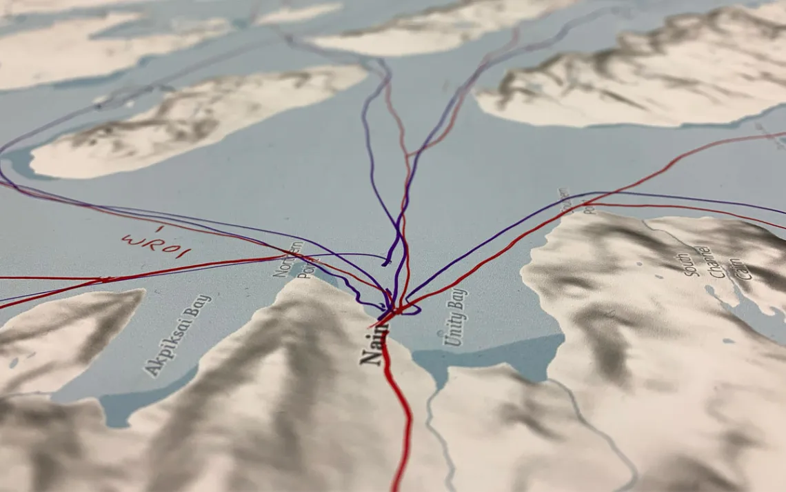
Oceanographic researchers at Dalhousie University collaborated with Nunatsiavut community members to map the region's ocean and sea ice travel routes. | Photo by Breanna Bishop
Maps have long been used as tools of colonial power. “More Indigenous territory has been claimed by maps than by guns,” wrote American geographer Bernard Nietschmann in 1994. Early settler-colonial maps of the Arctic tell a story of empty wilderness obliterated by blizzards, and inhospitable, ice-locked ocean passages punctuated by shipwrecks. These ideas—many of which persist today—of the Arctic as a white desert, or terra incognita, erased the long human history in the region, paving the way for colonial occupation.
Now, Inuit maps of the Canadian Arctic are acting as tools of resistance. Sometimes called counter-mapping, these projects aim to center Indigenous knowledge and establish a cultural record across the landscape. In addition to reinstating Inuit place-names, the maps depict natural resources, travel routes between communities, and other lived experiences instead of the fixed, abstract representation of place so common on colonial maps.
“It’s an approach that is intended to mirror real life on a map,” said Breanna Bishop, a lead researcher on the first sea ice travel map booklets of Nunatsiavut, or Inuit Labrador.
Sharing intergenerational knowledge
The 2023 Nunatsiavut project was a collaboration between oceanographic researchers at Dalhousie University and Nunatsiavut elders and community members, and began as a way to bridge Inuit knowledge of ocean currents and sea ice with Western scientific research on the subject. The result was mapped travel routes that showed how people engaged with the sea, where they traveled by boat or dogsled, and what snowmobile routes they took to hunt and fish.
The work involved participatory mapping, where large-scale floor maps were laid out and community members were invited to populate them with Nunatsiavut oral history, knowledge that has been passed down for generations. “One participant said it felt like going home, retracing this journey to where they grew up or once lived out on the land before they moved into communities.” The mapping sessions were open to the public so that even community members who weren’t directly participating could learn from what was being shared.
Far from denoting dominion or possession, the focus on the lived experience in these maps is an important one when looking at Inuit culture. “Inuit named places by the five senses; the names refer to what happened there or how the land was,” said Aqsatunguaq Pitseolak-Ashoona, an Inuktitut language specialist from Kinngait. The settlement of about 1,400 people is located off the southeastern tip of Baffin Island, Nunavut. One peninsula is described as "a place where the rocks have been warmed by walrus, a resting spot for walrus in the fall, a dangerous place to travel in winter."
Pitseolak-Ashoona works with the Inuit Heritage Trust (IHT) on traditional place-name maps and was a collaborator on the Siku Atlas, which maps Inuit sea ice knowledge in Nunavut. “Some of these names were lost; no one practiced saying them, but now we have these maps,” she said. The IHT maps Pitseolak-Ashoona helped create with knowledge from Nunavut elders also included inukshuks, a type of traditional marker of cairns, which are used as beacons, indicating safe travel routes over snow and ice, as well as where people lived.
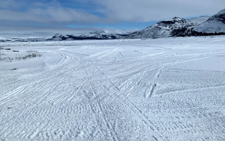
Travel routes over the ice near Nain, the capital of Nunatsiavut. | Photo by Breanna Bishop
Making the invisible visible
In addition to recording important cultural and environmental knowledge, the maps demonstrate how traveling and cultural identity are deeply intertwined. “People were living on the trail, not just getting from A to B; the journey was life as much as a fixed place was,” said Claudio Aporta, an Arctic ethnographer and co-director of the 2014 Pan Inuit Trails Atlas, which records Inuit open-water routes, walking trails, and sled trails over sea ice, including across the Northwest Passage.
The trails are seasonal, following the availability of animals, and the ephemeral nature of semi-nomadic life and the coastal landscape means there are few built structures remaining. The Inuit were semi-nomadic for most of history, only moving into permanent settlements in the 20th century, some forcibly under the federal government during the Inuit High Arctic Relocation. “Archaeological findings are fragments of the story, and what really reflects the multidimensions of Inuit historical land use are the narratives of oral histories—the maps are a reflection of that oral history,” said Aporta. “They make visible an invisible history.”
That history has been integral to advocating for Indigenous sovereignty in Canada. The 1973 Inuit Land Use and Occupancy Project was the first large-scale cultural mapping project of the region and supported Inuit land claims that eventually resulted in the creation of Nunavut in 1999, which means “our land” in Inuktitut.
The Pan Inuit Trails Atlas, Siku Atlas, and other similar projects, including Arctic Seas, a map created by a network of Inuit communities across Canada that shows how they conceptualize their coastal homes, also illustrate how interconnected the Inuit are. This rich social fabric is a far cry from settler-colonial maps that depicted the Arctic as mostly uninhabited, with very isolated communities. These maps show a vast region of shadowy taiga, or boreal forest, green tundra, and snow-cloaked sea ice carved with a rich network of trails along which people and ideas move.
A vision for the future
While these maps preserve the past, they’re also charting a course for the future, acting as a baseline for a landscape that’s shifting rapidly. “Especially around Kinngait, there are so many islands, and in the winter, it gets really dangerous now,” said Pitseolak-Ashoona. The Arctic is warming four times faster than the rest of the globe, and sea ice is shrinking by 12.2 percent every decade, according to NASA. This makes sea ice travel a concern and threatens traditional Inuit practices, such as hunting and fishing.
Although at the project’s outset, the Nunatsiavut sea ice travel maps weren’t intended to be used for navigation, Bishop said the five communities they were distributed to have referenced them for safe travel, and they have even been shared with emergency response teams. The hope is that they may help predict coming change, and that future iterations might be created in response to these climatic shifts.
As climate change rapidly transforms the landscape, the significance for industrial development is also shaping northern geopolitics. Longer and more navigable seasonal shipping routes through the Northwest Passage (which Canada claims as internal waters, but the US and European Union assert is an international strait); new commercial routes, such as the Transpolar Sea Route; and more accessible mining and drilling across the Arctic, are drawing global competition for control. Increasing extractive industries would have far-reaching effects on the entire ecosystem, according to a report by the Arctic Council.
There’s a possibility that Inuit maps might come into play again, as they did in the creation of Nunavut, especially in contested waters. New maps of an increasingly ice-free Arctic Ocean imagined by industrial powers might be marked by efficient shipping lanes through seemingly open, empty ocean. But Inuit counter-maps show a human presence in these icy waters, acting as a reminder that they hold a cultural significance with implicit rights. “Maps are powerful symbols,” said Aporta. “These Inuit maps tell a different story.”