Windy Work
Some of the worst weather in the world is offering up some of the most innovative solutions to weather technology
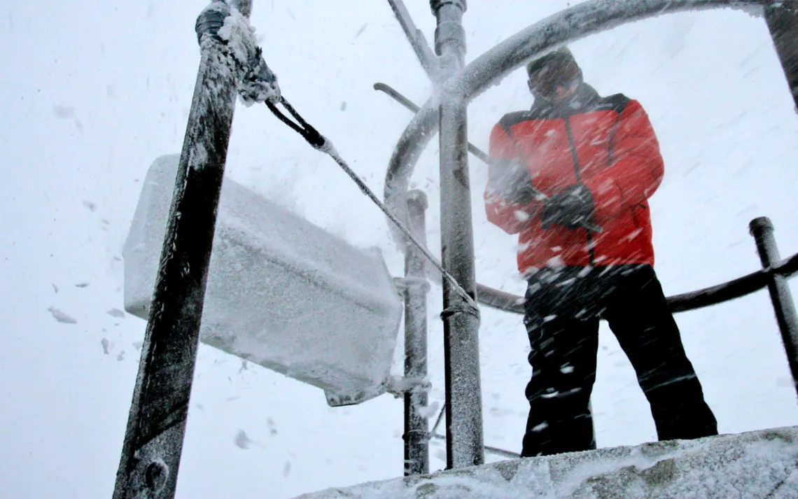
Jim Salge knocks ice off equipment on the top of the weather observatory on Mount Washington in New Hampshire. | Photo courtesy of AP Photo/Jim Cole
At the Mount Washington Weather Observatory in New Hampshire, the most important tool for data gathering is not a barometer or a lightning detector or even a thermometer. It’s a sledgehammer. Every hour, on the hour, weather observers like Charlie Peachey use the metal tool to knock off the rime ice that accumulates over the weather tower’s surface. Here, at 6,288 feet above sea level, exposed to wind that whips up to 200 miles per hour and snow that drives to the point of whiteout, the health and well-being of data instruments is top priority. They must not fail.
On a late-March day, with almost zero visibility at the summit, Peachey swung the sledgehammer with athletic velocity, connecting it to one of the tower’s metal railings. The structure rang out in the muffled cry of a bell. Rime ice exploded off the tower and blew away in the wind. I ducked to avoid a direct strike.
The mountain’s exposed summit notoriously has the “world’s worst weather,” a superlative that’s made its way onto postcards sold in the Mount Washington visitor center. In a historical context, this holds up. In 1934, a group of three scientists running an improvised data-gathering operation out of a repurposed wooden shack measured the largest gust of wind ever recorded by humans. It clocked in at 231 miles per hour.
For a generation prior, hikers and adventurers had been visiting the mountain and documenting its mercurial weather patterns in memoirs, newspaper articles, and poetry to the point of anthropomorphization. Edward Augustus Jenks’s 1897 ode to the mountain observed that the peak, “within whose cells the storm-winged Furies sleep,” shakes “his sides with glee,” indicating that the mountain enjoyed punishing people with its foul weather.
The ferocity of Mount Washington’s winds has laid to waste the standard tools of weather measurement—more specifically, the anemometer, which is essentially a sideways windmill with little cups used for catching and measuring wind speeds. A big enough gust can destroy one. Necessity being the mother of all invention, the meteorologists at the Mount Washington Weather Observatory (MWOBS), after years of trial and error (and shredded anemometers), arrived at a surprising solution: the pitot tube, which is commonly used on aircraft to measure airspeed.
Pitot’s svelte, streamlined body doesn’t get wrecked in the wind the way an anemometer does, with its delicate arms and cups. But it does all the same good work of measuring wind speed. The invention has been so effective and indestructible that it’s now being used on two of the world's highest and hardest-to-study peaks—Aconcagua in Argentina and Mount Everest in Nepal.
“Everest is one of the few places in the world where the land surface actually intersects with the subtropical jet stream,” explained Baker Perry, a professor of climatology and the Nevada state climatologist at the University of Nevada, Reno. “There's so much to learn from that.”
Perry, who is also a National Geographic Explorer, has traveled to both Aconcagua and Everest to install MWOBS pitot technology. What Perry and his team set up at 26,000 feet needs to be transported in their packs. At 10 inches in length and weighing less than a pound, pitot tubes make that possible.
On the cloud-shrouded Mount Washington, folks like Peachey and the rest of the weather observers use the pitot technology to collect wind speed data that then gets used in a myriad of ways, including by the National Weather Service, local news outlets, and the observatory’s website to build daily forecasts. It also, crucially, gets entered into the data that MWOBS has been collecting for 90 years. Perry, on the other hand, is using the pitot technology for different projects on Aconcagua and Mount Everest.
“This is where the bulk of the snow and ice outside the polar regions is found,” Perry noted, making the distinction between the planet’s poles and some of its highest peaks. What happens to the water at 29,000 feet—whether it accumulates or sublimates or literally blows off the mountain—determines how much water the people and the crops have at sea level. “These are the water towers of the world,” he explained. What we can learn from these remote ceilings likely has lessons for us all down below.
Innovations such as the pitot and intergenerational data records are why places like MWOBS and its sister station, the Blue Hill Weather Observatory in Milton, Massachusetts, play such a pivotal role in our knowledge of weather. We study the weather because we are inextricably linked to its behavior. This simple fact is what makes knowing about its traits and patterns a matter of life or death, as many people who I spoke with for this piece noted.
The two observatories offer researchers up-to-date information as well as historical records, both of which are invaluable to the current and future of climate studies. As Brian Fitzgerald, director of education for the observatory, put it, “There are very few places in the world that contribute the same level of resources and care and consistency to understanding what is happening at the higher parts of our atmosphere.”
Both MWOBS and Blue Hill benefit from federal government money that is now under threat by the current administration, but as Don McCasland, the director of operations at Blue Hill, assured me, both observatories have the resources to weather this storm. Rather than relying solely on federal funding, they run on a nonprofit model. Even if, or when, the government contracts are canceled, others exist with local and national funders that hopefully can fill the vacuum.
“We are somewhat insulated,” McCasland told me. But already the crisis in federal funding is not completely hypothetical: Three days before Perry and his team were to depart for Aconcagua, their federal grant from the State Department was frozen. The team went forward with the trip, and ultimately the grant was reinstated, but “it does lead us all to just question the reliability of federal funding moving forward for sure,” remarked Perry.
Though on a clear day, you can see 130 miles in every direction from Mount Washington’s weather tower (two countries, five states, and one ocean, in fact), when the conditions deteriorate, so do the physical circumstances for the people at the observatory. In foul weather—frigid, windy conditions—the rime ice, which freezes on any surface with which water molecules collide, makes frozen masterpieces of feathers, comets, and starbursts.
This often demands a grueling physical effort on behalf of the observers, who are exposed to the elements on the catwalk of the instrument tower and when they beat back the ice with the sledgehammer. The pulse of the whole operation at the summit is in the shifts and the work, but so much of the work’s success depends on our human ability to survive in hostile climes. The data wouldn’t exist without people out there grappling with the elements to make sure it's being collected.
I asked Perry, after having been to the tops of the Andes and the Himalayas, if Mount Washington really does have the worst weather in the world. “We did a quick analysis after we had the first year of data from Everest and confirmed that on its worst days, the weather on Mount Washington is just as bad as it is at the South Col,” he remarked, referencing one of the deadliest passages of the Everest ascent. “It can be pretty fierce out there.”