Important Water Bills in Legislature
The Texas Legislature is entering its last couple of innings as it gets ready to head down the home stretch towards sine die. There have been a surprising number of rational and responsible water-related bills that have seen positive movement in hearings and on the floor of both the House of Representatives and the Senate.
Perhaps most important of all these bills this session are the two “big” water bills – Senate Bill (SB) 7 by Senator Perry and House Bill (HB) 16 by Representative Harris. These two bills, and their associated constitutional amendments, would provide dedicated and recurring funding for Texas water infrastructure and water supplies.
SB 7 recently made it over to the House Committee on Natural Resources and now includes positive changes for which many various environmental and water industry groups have been advocating. The Greater Edwards Aquifer Alliance was very encouraged to see water and wastewater reuse project be added to the list of projects for which the New Water Supply for Texas Fund can be used, and of course, we remain fully supportive of the ability of aquifer storage and recovery projects to continue to receive these funds.
The bill also adds the Flood Infrastructure Fund, the Economically Distressed Areas Program Account, wastewater infrastructure projects, and technical assistance to the list of programs and projects that can receive funding from the Texas Water Fund. GEAA is happy to support the use of funds in this manner. Like many groups, we are still concerned about the emphasis being placed on produced water recycling, surface reservoirs, and potential cross-state transfers, and the lack of emphasis on funding water loss mitigation projects, such as repairing aging and leaking pipes. But we remain supportive of the bill overall – Texas water needs all the help it can get!
Though we don’t yet know all the details regarding SB 7’s final form, it is almost certain that it will make it to the House and Senate floors to be voted on by both chambers. But the work doesn’t stop once the legislature has passed the bill and Governor Abbot has signed it. Texans will need to head to the polls in November to approve the constitutional amendment that dedicates revenue to the Texas Water Fund.
The Greater Edwards Aquifer Alliance, along with many other groups, will continue to do our best to keep Texans aware of opportunities to support Texas water. Keep an eye out on our alerts and actions to stay updated on how you can get involved, especially as the November election rolls around!
by Rachel Hanes, Policy Manager, Greater Edwards Aquifer Alliance
Inner Space Cavern Reveals Animals of Ice Age Texas
Our May general meeting will feature John A. Moretti, from Jackson School of Geosciences, University of Texas at Austin. He will describe the famous Inner Space Caverns, how its Ice Age fossils inform our understanding of the ancient history of the Texas Hill Country, and how changes in the past led to the biodiversity of today.
Tuesday, May 20th
6:00 pm
Meeting schedule
| Informal get-to-know-you | 6:00 pm to 6:15 pm |
| Announcements | 6:15 pm to 6:30 pm |
| Featured program | 6:30 pm to 8:00 pm |
Venue
This is an in-person only meeting at:
William R. Sinkin Eco Centro, 1802 North Main Avenue
Map
Program topic
Since its discovery in 1963, Inner Space Caverns, located in Georgetown, north of Austin, has been famous for its rich abundance of Ice Age fossils, representing mammoths, extinct horses, saber-tooth cats, and other animals that went extinct over 11,000 years ago.
Recently, new fossils have been recovered of bats, jaguars, and tiny antelope-like pronghorn. Research and analyses of those fossils are providing new insights about the origins of the native fauna of Texas. Inner Space Caverns contains one of the oldest, longest, and most important troves of Ice Age fossils anywhere in Texas. Come learn more about this famous cave and the ancient history of the Texas Hill Country!
About our speaker
John Moretti is a doctoral candidate studying vertebrate paleontology in the Jackson School of Geosciences at The University of Texas at Austin, and ardent caver. His research seeks to document natural history and investigate patterns of change in the animal community of North America over the past 3 million years. He explores caves across the Edwards Plateau of Texas, obtaining new evidence of how animal communities change over time, and how such changes have led to the biodiversity of today.
The Alamo Group of the Sierra Club holds its general meetings the 3rd Tuesday of most months. They're always free and open to the public.
People and Climate Change
According to Chris Hayes in his 2025 book The Sirens' Call: How Attention Became the World's Most Endangered Resource, climate activist Bill McKibben told him "It's always been a problem that the most dangerous thing on the planet [CO2] is invisible, odorless, tasteless, and doesn't actually do anything to you directly." It is because CO2 does not attract our attention that it is so dangerous.
In his 2020 book Why We’re Polarized, Ezra Klein points to research by Dan Kahan, et al., that found that people who were already skeptical of climate change were more skeptical when provided with more scientific evidence. “The smarter the person is, the dumber politics can make them,” concludes Klein. This is an example of “confirmation bias”, the tendency we all have to search for, interpret, favor and recall information in a way that confirms or supports our beliefs or values.
In addition, the Dunning-Kruger effect fuels overconfidence among the uninformed, which obstructs effective climate action. Scientists and experts may be drowned out by confident non-experts in media and public forums. It can also create false equivalence, where fringe views are given equal weight as peer-reviewed science. So, addressing climate change is a challenge for many reasons.
To be effective, work with like-minded people and don’t waste time with skeptics. To be successful, we need to be aware of how people think!
by Bill Barker, Alamo Group executive committee member
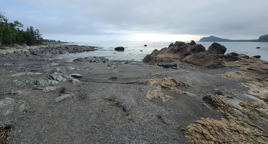
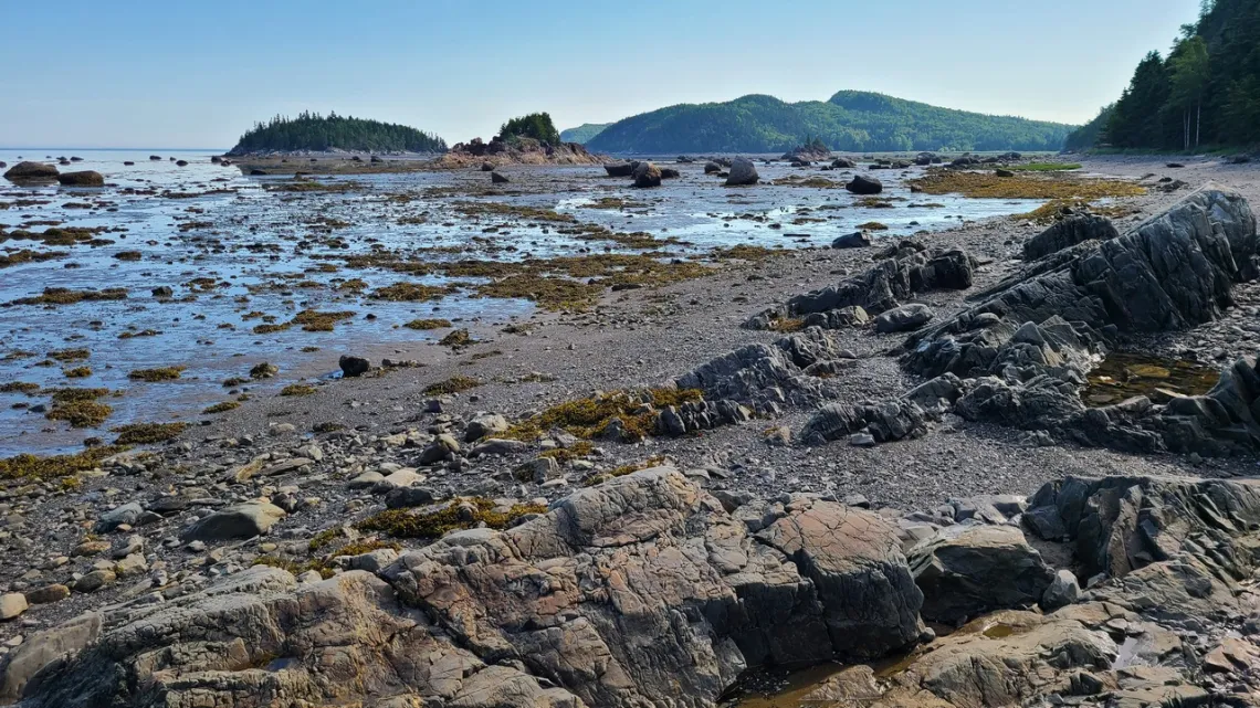
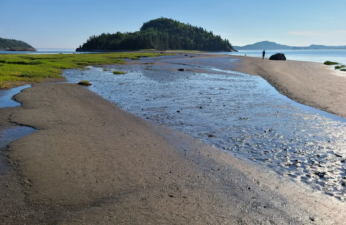
In Quebec on the St. Lawrence River - Du Bic Park, and Continental Divides
Du Bic is on the south side of the St. Lawrence, due north of central Maine. Here's the website. Referred to as a national park but actually is a Quebec park; they don't deal with Canada national park passes. Great hikes along the coastline of the park. There are reservable campgrounds which were totally full when I got there; park staff mentioned a municipal campground just west of the park in Saint Fabien. Indeed! Nice available campsites and an information center and store. Free wifi as at other Canadian parks which works fine for international wifi calling. These pictures were taken in Du Bic early July 2024.
The St. Lawrence River
Wikipedia has a very good page with many further page links about the river, the Great Lakes, Great Lakes Basin, the Indigenous people originally here, etc. From the initial page: “As the primary drainage outflow of the Great Lakes Basin, the St. Lawrence has the second-highest discharge of any river in North America (after the Mississippi River) … The estuary of the St. Lawrence is often cited by scientists as the largest in the world.” I have a childhood connection with this; growing up in Riverview, Michigan south of Detroit, with the house about a mile from the Detroit River, which connects Lake Huron via Lake Saint Clair with Lake Erie.

The St. Lawrence River Divide and Others Across North America
Another good Wikipedia page linked from the one above shows a map of the six divides in North America. A bit about the St. Lawrence River Divide: “...is a continental divide in central and eastern North America that separates the Great Lakes-St. Lawrence River Basin from the southerly Atlantic Ocean watersheds. Water … drains into the Gulf of St. Lawrence or the Labrador Sea; water south and east of the divide drains into the Atlantic Ocean (east of the Eastern Continental Divide, ECD) or Gulf of Mexico (west of the ECD). The divide is one of six continental divides in North America that demarcate several watersheds that flow to different gulfs, seas or oceans.”
In addition to the two divides mentioned above the four others in particular include the Great Divide (aka Continental Divide), and Great Basin Divide. The former was mentioned in an article in this newsletter October 2015 (PDF), which included the same map and discusses Triple Divide Peak in Glacier National Park, the only place on Earth where water divides to three oceans. Also in April 2023 about a spot in Colorado on the Continental Divide Trail (CDT) actually on the Great Divide, and November 2024, about bits of the CDT in southwestern Colorado. About the Great Basin Divide, in a October 2023 article The Great Basin: the Largest Area in North America Where Waters Are Stuck.
by Kevin Hartley, Sierra Club Life Member
Outings: The Call of the Wild
Visit the Alamo Sierra Club Outings page on Meetup for detailed information about all of our upcoming Sierra Club Outings.
The Alamo Sierran Newsletter
Richard Alles, Editor
Published by the Alamo Group of the Sierra Club, P.O. Box 6443, San Antonio, TX 78209, Website.
The Alamo Group is one of 13 regional groups within the Lone Star Chapter of the Sierra Club.
Changed your contact information?
If you're not sure whether the Sierra Club has your current email address, send an email to Member Services with your name and address and/or member ID (see Locating Your Member ID) so they can add your email address to your member record.
Have you moved? Let us know by sending your old address, your new address and your member ID to: address.changes@sierraclub.org.
Go online for the latest news and events
 |