By Karl Kempton
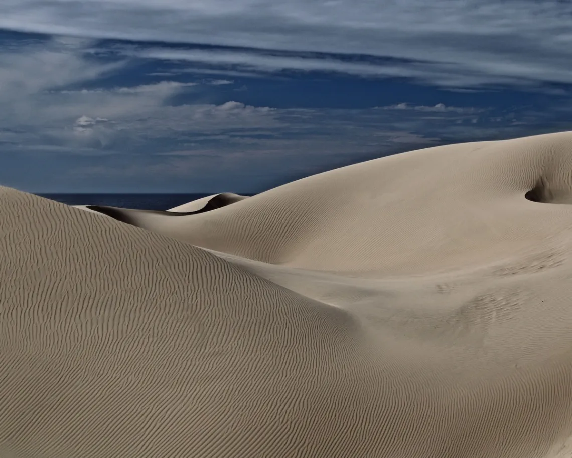
A person standing on a high northern coastal hill of San Luis Bay experiences breathtaking views on clear days of the bay and south beyond Point Sal to Point Arguello, about 45 miles away. Pristine waters reflect a sun-lit, platinum-brilliant sheen. Throughout the year and across times of day, hues of oceano blues dance, shaped by wind and current. A few miles south, the Oceano–Nipomo–Guadalupe Dunes stand out along the 20-mile arc of sandy beach from Pismo Beach to Point Sal. On high-surf days, the arc is rimmed with white breaking waves, mist moving inland and over the foredunes. The bay is now protected within Chumash Heritage National Marine Sanctuary waters.
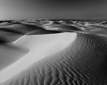
The dunes were perhaps first brought to national attention in the 1930s with early photographs by Edward Weston and Ansel Adams. They were visiting the relatively unknown bohemian group living in the dunes between the World Wars, now called the Dunites. Adams’ photographs from circa 1950 and 1963 remain the most iconic of his dune series.
The largest coastal dune complex in California, and the state’s second-largest dune complex overall, the Oceano–Nipomo–Guadalupe Dunes are more than an opportunity for photographic awe and wonder. With its wetlands, endemic flora, birds, sea and land mammals, and haul-outs, it was designated a Natural Landmark in 1974. The landmark, under the National Park System, consists of two contiguous areas:
- the Oceano–Nipomo–Guadalupe Dunes, fed by sand carried by offshore currents circulating within the Santa Maria River Littoral Cell; and
- Point Sal, one of the last remaining pristine rocky coastlines on the South Coast.
This dune complex also contains the highest measured dune along the entire West Coast of the U.S. Though voluntary, the National Park System expects private and public owners and jurisdictions to protect the landmark as if it were a national park.
The Setting
The dunes have immeasurable ecological and scenic value, along with educational and scientific importance, and represent one of the few coastal areas in the state still in an undisturbed condition—excluding designated recreational areas where, in some locations, the California Department of Parks has allowed complete obliteration of large swaths of flora and foredunes. Such destruction has destroyed habitat for threatened and endangered fauna, as well as resulted in unknown destruction of specific threatened and endangered plant species.
The area includes long beaches, headlands, estuaries, and lakes. Many plants are rare; a high percentage are endemic to the region. There are 22 listed state and federal threatened or endangered plant species and 20 animal species. At least 186 species of water and terrestrial birds have been recorded, including the Least Tern, the Peregrine Falcon, and the Southern Bald Eagle.
The unique combination of semi-arid and aquatic conditions, together with a climatic and oceanographic transition zone, provides a wide variety of habitats and associated plant and wildlife species. Coastal dunes, freshwater marshes, riparian habitat, coastal salt marsh, woodland, mudflats, beaches, open water, and transitional zones between habitats support a diversity of life uncommon in much of California.
Drainage from separate watersheds contributes to the wetland complex. The 1,880-square-mile Santa Maria River drainage is California’s fourth-largest coastal river basin. Extensive tidally influenced wetlands sit at the river’s mouth. The river’s historic floodplain contains the Oso Flaco Lakes and their associated coastal wetlands. The ten existing dune lakes are likely remnants of a former freshwater estuary.
About 186 species of water-associated birds have been recorded in these wetlands. Shorebirds, waterfowl, gulls, terns, pelicans, cormorants, coots, rails, loons, grebes, herons, and egrets are among those counted. Least Terns nest and raise fledglings near the Santa Maria River mouth and the Oso Flaco Lakes. Brown Pelicans roost along the shore, and Snowy Plovers inhabit the beaches. Over 100 terrestrial bird species occur among the dunes and related habitats, including the endangered Peregrine Falcon and the Southern Bald Eagle.
Several plant species are found nowhere else. Two species—one aquatic and one terrestrial—reach their extreme range limits within the dune complex. At least eight species occurring in the dunes have been listed by the California Native Plant Society as “very rare” or “rare and endangered.”
Nearly 50 species of mammals and 33 species of amphibians and reptiles inhabit the dune region. Though not abundant, fish are found in the lakes. A wide diversity of invertebrates is present. The Pismo clam, long the subject of recreational and scientific attention, disappeared in 1993 and was suddenly found again along the beaches around 2018. Of the fish species, steelhead require unobstructed access to Arroyo Grande Creek. State Parks, without permits, altered the natural course and flow of the creek into the ocean to provide easier vehicle access to the beach. The consequences for steelhead remain unknown.
Threats: Agricultural Chemicals
The Santa Maria River watershed is the fourth largest along the California coast. The western portion of the drainage runs through intensive, chemically-based agriculture upon entering the Santa Maria Valley, causing agricultural chemical pollution comparable to that of the Salinas River, which pours into the southeast corner of San Luis Bay just north of Point Sal. The pollutant chemical mix causing synergistic impacts includes:
- organophosphates such as chlorpyrifos and diazinon, historically associated with acute toxicity in river water;
- pyrethroids, frequently found in river sediments and highly toxic to aquatic invertebrates; and
- neonicotinoids, which impair aquatic life in the lower watershed and fail to meet toxicity safety standards.
As the river flows into its estuary and eventually into San Luis Bay, these chemicals threaten marine life through several mechanisms:
- benthic degradation—the Santa Maria River estuary has remained significantly degraded for years, lacking healthy benthic macroinvertebrate communities that form the base of the marine food web; and
- acute and chronic toxicity—mixtures of pyrethroids and organophosphates in the estuary often exceed toxicity thresholds, leading to mortality among resident invertebrates. Upon entering the bay, toxins are captured by the Davidson Current, a three-mile-wide pole-bound flow adjacent to the coastline.
Illustrative of ongoing carelessness and indifference by state, regional, and local government agencies is the long-standing warning sign advising against eating fish from Oso Flaco Lake. The lake is fed by a small creek whose length runs through chemically treated agricultural fields. The lake empties between the foredunes into the bay, adding to nearshore entrained toxins moving north.
For years, farmers denied the drift of agricultural pesticides, herbicides, and other sprayed chemicals. However, during conflicts a few years ago with newly approved cannabis farmers, chemically-dependent farmers admitted—while arguing against adjacent cannabis farming—that pesticides from their operations would drift onto neighboring crops. Agricultural chemicals and fertilizers also mix with wind-borne dust during plowing. The accumulation of these chemicals over decades has had unknown impacts on dune flora and fauna. Intensive chemical agriculture borders the dunes from Oceano to the Santa Maria River mouth.
Offshore Seismic Testing
In 1982, offshore oil leases were offered by the Reagan administration. In 1983, oil companies investigating lease values reportedly tossed dynamite overboard from survey ships. A known result was the total collapse of fishing in the bay for a year. Damage to world-class benthic communities remains unknown, though these communities were already impacted by net dragging and radically reduced landing numbers.
Nation’s Largest Underground Spill
In 1985, Santa Barbara Surfrider successfully lobbied the Santa Barbara County Board of Supervisors to lift a no-surfing ordinance at the Santa Maria River mouth, originally justified as protection of sensitive habitat. Once public access was gained, surfers discovered oil sheen in the waters. This led to the discovery of an underground spill of 8 to 20 million gallons of diluent—a kerosene-like thinning agent used to liquefy heavy crude oil—leaking into the water. Unocal resisted admitting responsibility and undertaking cleanup for years. Cleanup continues under the third owner, Chevron.
The known area of contamination covers approximately 2,700 acres. Eighty identified plumes, some extending more than 125 feet deep, sit atop the water-table barrier. The true extent of leakage remains unknown due to poor or missing records. Estimates range from 8 to 20 million gallons. How much migrated into the bay remains unknown.
The spill likely began shortly after pipelines were installed to transport extremely viscous crude oil requiring diluent for movement to a nearby refinery. Refined oil was later transported via pipeline to an oil tank farm overlooking Avila Beach, built in the 1930s atop a sacred Chumash ceremonial dance site more than 10,000 years old. Oil from the tank farm was piped to nearshore anchored tankers destined for the Unocal Richmond refinery.
By 1990, oil was seeping beneath the Avila Pier, prompting the first phase of Avila Beach cleanup—this time involving partially refined oil leaking into the ocean. Contaminated sand was removed in 1991, but Unocal was permitted to replace it with river sand, resulting in the beach’s unusual texture and appearance compared to neighboring beaches. This phase has largely been forgotten, overshadowed by the later cleanup that destroyed the original Avila Beach village and led to its reconstruction in a contemporary form.
Entrained Toxins and Sewer Expansion
There remains, locally, the undiscussed issue of nearshore toxins. The nearshore and pole-bound Davidson Current entrains the toxins discharged by the Santa Maria River, carrying them northward along the coastline of the bay. Additionally, it transports toxins from the underground diluent spill. These mix further north in the bay with the “toxin soup” discharged from the daily 2–3 million gallons of secondary-treated water from the outfall of the South County Water Treatment Plant. Its expansion, completed in 1986, was designed for biological processing but turned chemical under the Wallace Group, thereby reducing efficiency and adding more pollution to the bay.
The San Luis Obispo South County Water Treatment Plant discharges through its outfall off Arroyo Grande Creek directly into San Luis Bay nearshore. The outfall pipeline was built cheaply. It was not extended beyond the reach of nearshore wave, tidal, and circulation forces, thus keeping the discharge near shore. It pollutes the nearshore ocean waters and beaches with its processing chemicals and other chemicals not captured within the treatment process, including detergents, household cleaning agents, medications, and a variety of industrial chemicals, all toxic to the ecosystem. Clams, as filter feeders, ingest these toxins. The Wallace Group was removed from operating the plant in 2013 due to conflicts of interest. The new operators run the plant biologically, as designed, substantially reducing pollution into the bay.
Within a year of the changeover, an explosion of sand crabs was observed. This attracted previously unseen numbers of shorebirds—sanderlings, willets, and sandpipers being the majority. Soon thereafter came the “unexplained” return of the Pismo clam.
In the late 1970s, endangered sea otters appeared at Pismo Beach, preying on the Pismo clam population already in decline from human over harvesting. By 1993, they disappeared. The otters were tried and found guilty by the “kangaroo court” of fishermen, shell-fishers, and urchin divers. Then, suddenly, they returned. The sea otters had never left. The oldest of the new population coincides with the turnaround of the water treatment plant. State, regional, and local officials, as well as Cal Poly professors, have been informed of this fact—a fact they cannot otherwise explain—but either refuse to believe it or want it kept secret due to the potential public outcry over their prior inability to recognize the pollution source and its history of damage.
Along the Shore of the Dunes
In 1978, a Cal Poly student released a series of aerial photographs documenting off-road vehicle behavior in the Oceano Dunes Off-Road Vehicle Area. The photos showed the deliberate destruction of foredunes and vegetation—dune buggies ramming, backing up, and ramming again. State Parks staff stood by, doing nothing, despite the agency’s stated mission to protect habitat and species while providing recreational opportunities. For years, they turned this mission upside down. Literally caught on camera, they eventually stopped the destruction, but it was too late: a wide gap in the dunes opened, allowing wind to blow directly across the off-road area, causing harm to downwind residents, human and nonhuman.
State Parks repeatedly promotes the revenue stream generated by dune buggy riding and beach driving adding to the Coastal Economy. The figure now frequently cited is 2.2 million visitors per year to the landmark area. They, of course, refuse to discuss the consequences of beach and dune vehicular pollution.
Beach and dune vehicular pollution comes from several sources. The primary concern—particulate matter caused by churning and grinding sand—is only one problem. While its impact on humans and pets living downwind is well documented and alone sufficient to justify closing vehicle access to the beach and dunes, there appears to be little or no study of such impacts on listed threatened and endangered species.
Several petroleum products of unknown quantities drip from vehicles on the beach or dunes, all toxins to the ecosystem. Additional pollutants enter through exhaust. Many vehicles—being off-road or trucks—lack street-car regulations. Further, State Parks has yet to post restrictions prohibiting vehicles from driving into the Chumash Heritage National Marine Sanctuary, beginning at the mean tide line. All species injuries or deaths in this area involve inhabitants protected by federal law.
Not studied either is the damage to the ecosystem caused by the corrosive action of sand on vehicle tires. Tires are known to contain benzene, mercury, styrene-butadiene, polycyclic aromatic hydrocarbons, arsenic, other heavy metals, and carcinogens.
State Parks, as mentioned, promotes the figure of permitted traffic volume to be over two million “trips” per year on the beach and in the dune. The not-assessed combined pollutants must be assessed not as suburban street pollution but as that of a busy urban thoroughfare.
Here lies the gem of the Oceano-Nipomo-Guadalupe Dunes National Landmark, supposedly maintained at a National Park level under a voluntary agreement. Instead, we witness unregulated, consciously careless degradation of habitat and its inhabitants.
The state’s COVID closure of state parks—including the beach and dunes—for a year beginning in 2020 provided an opportunity for those opposed to vehicles to record a “before and after” comparison. Most observers were amazed at the speed of recovery. Previously unseen species appeared. Populations of known and expected species increased. The beach quickly returned to a state of natural wildness: soft wavy sand, small foredunes forming, and the natural wind-swept crust on tire-churned dunes returned, greatly reducing downwind particulate matter.
After a year of local and visitor pedestrian enjoyment, the beach and dunes reopened to off-road vehicle traffic. Approximately eight hours after the first vehicle entered, all newly built sand features were flattened. The previously unseen returning birds left and have yet to be seen again. Particulate matter increased to pre-COVID closure levels. Bus-sized recreational vehicles drove over returning clams at low tide. State Park staff did nothing but turn their backs on the protection of species and habitat.
For years Fred Collins of the Northern Chumash Tribal Council had been urging and then, after much delay, demanding protection of the Chumash shell middens in the dunes from vehicles. State Park finally agreed. By the way, the middens contain significant numbers of Pismo clam shells, proving there was once a balance with the sea otter.
The experience of a vehicle-free beach created a new public push to close the beach and dunes to vehicles. Collins gave a tour to California Coastal Commission staff members and a voting member of Oceano Beach and the Off-Road Vehicle Area. In March 2021, the CCC voted unanimously to close the beach and dunes by July 1, 2025. The offroad group Friends of the Dunes sued the ruling and won in court; the judge ruled that only the County can alter its Local Coastal Plan.
A glimmer of hope for greater protection was opened in 2025, when State Parks lost a lawsuit filed by the Center for Biological Diversity for noncompliance with the Federal Endangered Species Act. State Parks’ response in their proposed Habitat Conservation Plan, however, shows it remains committed to recreation over significant habitat and endangered species protection.
The beach and dunes remain open to vehicles. The county is now clearly responsible for aiding and abetting the degradation. Where is the regional, state, and national organizational pressure to close the beach and dunes to traffic? The Nipomo-Guadalupe Dunes National Landmark remains a gem that requires help polishing itself to its original potential. It is time for regional, state, and national organizations to turn their attention to this gem and finally end beach and dune vehicle destruction. Mother Nature will then polish Her gem.
All photos by Karl Kempton