When floodwaters swept through Central Texas earlier this summer, it was a brutal reminder of a simple truth: for all our infamous droughts, Texas has a massive flood problem. In fact, no other state sees more destruction, or more lives lost, due to flooding than Texas. Every single one of our 254 counties has faced at least one federally declared flood disaster, meaning a flood so severe that the federal government had to step in to provide assistance for emergency relief and recovery.
For a long time, flood management was left to local governments, with each community largely left to fend for itself. But when historic storms like Hurricane Harvey hit, the weaknesses of that patchwork system became impossible to ignore. Last year, Texas Water Development Board (TWDB) adopted the state’s first-ever State Flood Plan, marking a historic milestone in how Texas plans for and manages flooding.
What Is Included In the State Flood Plan?
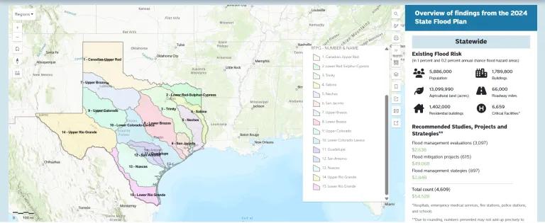
The 2024 State Flood Plan is the first comprehensive look at flood risk across the entire state. The scale of it is staggering, both in the problems it identifies and the solutions it proposes. Roughly one in every six Texans - more than 5 million people - works or lives in an area known to be a flood hazard. Nearly 1.7 million buildings and over 6,200 critical facilities like schools, hospitals, and fire stations are located in flood-prone areas around the state.
To protect Texas communities, the plan recommends over 4,600 flood mitigation solutions, with the estimated total implementation cost of $54.5 billion. It’s important to note that nearly half of that amount - $24 billion - is tied to the Galveston Bay Surge Protection Coastal Storm Risk Management Project (also known as Ike Dike). Other flood risk reduction strategies include upgrading or expanding stormwater infrastructure, improving low water crossings and bridges, using nature-based solutions, acquiring flood-prone properties, updating floodplain maps, and many others. If fully implemented, more than 840,000 Texans would be removed from the 100-year floodplain, or areas with a 1% yearly risk of major flooding.
Interactive State Flood Plan
Want to know the specific flood risks and projects for your region? You can explore this data and much more on the State Flood Plan Viewer. This interactive resource provides detailed, location-specific information on recommended flood mitigation strategies, including types of solutions, kinds of flood risk that are being addressed (such as riverine, urban, coastal), estimated costs, potential funding sources, and other details.
To use this viewer, click on your approximate location on the map to open a pop-up window with regional data for your specific region. To see recommended projects in more detail, click ‘View map data’ in the pop-up, and the map will zoom in on your region.
How Is the State Flood Plan Developed?
One of the most powerful aspects of this plan is that it wasn’t created in a closed-door meeting in Austin. Like the State Water Plan, Texas’ statewide flood planning is built from the ground up: by Texans, for Texans.
Following the passage of Senate Bill 8 by the 86th Legislature in the wake of Hurricane Harvey, Texas established a new flood
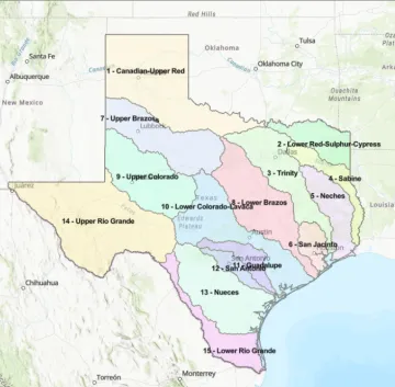
planning framework, modeled after the state’s water supply planning process. For the flood planning process, the state is divided into 15 planning regions that follow river basin boundaries. This type of approach ensures that communities upstream and downstream are working together, so a solution in one area doesn’t create a problem for another.
Each regional group is made up of local leaders, business owners, farmers, environmental advocates, and other community members. Planning groups develop their plans every five years, focusing on reducing current flood risks and preventing future ones. This process includes multiple public meetings throughout the development cycle. Attending these meetings helps ensure that regional flood plans accurately reflect local needs and priorities. Meeting schedules for each regional planning group are available on the TWDB’s website, and you can access your planning regional group’s webpage by clicking on your region.
Once each regional plan is developed, it’s submitted to TWDB. Drawing on local knowledge and public input, all 15 regional plans are then combined by TWDB into a single, comprehensive State Flood Plan, which also includes legislative recommendations, thus serving as a guide to state flood control policy.
Missed Opportunities at the Texas Legislature
Most of the policy recommendations listed in the State Flood Plan - including those from TWDB, regional flood planning groups, as well as recommendations for floodplain management (State Flood Plan, Chapter 2) - have yet to be acted upon.
Thus, the TWDB itself recommended adding specific action on low water crossings, early warning systems, a dedicated funding source, and technical assistance, among other actions. For their part, among other ideas, the regional planning groups recommended enhanced county authority on drainage, updating our state minimum building codes - particularly for floodplain development - establishing floodplain standards for buildings and infrastructure. While the Legislature finally addressed early warning systems during the second special session, it has largely ignored the recommendations of the State Flood Plan.
Making the State Flood Plan Work
All in all, a plan is only as good as our ability to implement it. While the State Flood Plan identifies $54.5 billion in needs, it also reveals a massive funding gap. The 2024 plan found that local communities may require financial assistance for up to 80-90% of the costs to implement the recommended solutions. The Flood Infrastructure Fund (FIF) provides state funding to communities for flood mitigation. However, to qualify for this funding, projects must be included in the State Flood Plan.
One bright spot is at least a beginning to address the funding shortfall through a dedicated funding stream. Proposition 4, appearing on the ballot this fall, is a key step toward ensuring consistent funding for the FIF. Proposition 4 is a constitutional amendment which proposes to dedicate $1 billion annually to the Texas Water Fund, a special state fund managed by TWDB to address Texas’ water needs. This funding would come from state sales tax revenue, but only after collections exceed $46.5 billion, so no new taxes are going to be imposed.
If approved, Proposition 4 would create a consistent, long-term funding source for various water projects, including flood mitigation solutions through the FIF. Reliable funding is essential for these risk reduction recommendations to move from planning to reality, protecting homes, businesses, and lives from future flooding. Currently, lawmakers must reallocate funds for the FIF every legislative session. A passage of Proposition 4 will provide stable support to protect Texas’ communities. Still, there is no doubt that even if voters approved Proposition 4, the Legislature will need to take additional actions to better protect Texans from flooding.