APPALACHIAN TRAIL
AND SHAWANGUNK TRAIL SECTION
of the NJ STATE LONG TRAIL
The Appalachian Trail (AT) is the premier National hiking trail in the eastern United States, extending 2,150 miles through 14 states, including 74 miles in New Jersey. 26 miles of the AT are a component of the NJ State Long Trail.
This section features the best vertical hiking along the trail and greenway in New Jersey, between High Point State Park and Wawayanda State Park. It has some fantastic views covering miles of north Jersey hills and forests. The AT is blazed in white paint 2” by 6” on trees and rocks. This is the national standard for long distance trails. (For more information, see the Appalachian Trail Guide to New York-New Jersey and the related maps printed by the New York-New Jersey Trail Conference.)
The Shawangunk Ridge Trail is a bi-state trail extending for 71 miles from the Appalachian Trail to the Catskill Mountains; three miles of its length are in New Jersey. It is blazed blue the color of the NJ Long Trail. 0.3 miles of the Shawangunk Ridge Trail are a component of the NJ State Long Trail.
|
Miles |
Detailed Trail Data From North to South |
|
0.0 |
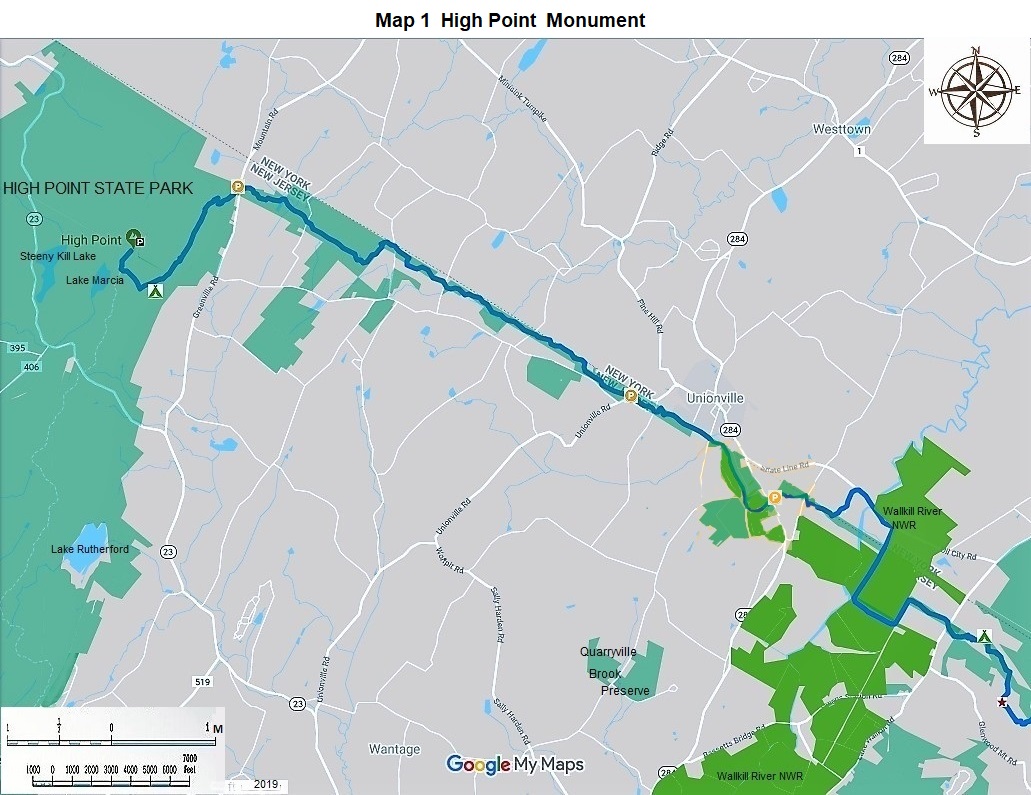
Began your hike at the top of the tallest mountain in New Jersey, 1,803 feet above sea level, at High Point Monument. There are great views from here. Walk up the stairs inside the monument for another 220 feet; get better views. The parking lot is large. It also has good views. Go north within the parking lot one block. Turn left or west; go downhill or south on the blue marked Shawangunk Ridge Trail for 0.3 miles, which is simultaneously the Monument Trail marked green and red. |
|
0.3 |
Come to the intersection with the white blazed Appalachian Trail. Turn left or east on it. Do not go straight or south on it. If you are coming from the east, make sure that you find this intersection and go north on it to the monument and parking. |
|
3.3 |
At this point you have come off the Kittatinny Ridge and reached the Kittatinny Valley, where you will have less slope but excellent hiking for 17 more miles. We, however, recommend that the corridor or greenway be widened to 300 feet through this valley for the movement of all forms of wildlife from the Kittatinny Highlands to the Wawayanda Highlands. Some species, such as the relatively rare, in New Jersey, bobcat and other smaller mammals and reptiles will not be able to move between these two protected areas when full development comes to the Kittatinny Valley without a wider greenway. |
|
10.1 |
Hike north, east, north, and east on the well-marked trail for 1.5 miles to cross the Wallkill River on Oil City Road in New York State and within the Wallkill River National Wildlife Refuge. The bridge is about 400’ above sea level. Hike east, south, east, and north within the refuge for another 1.8 miles. This refuge is famous for its marshes along the river which contain numerous water birds, amphibians, and mammals. |
|
Miles |
Detailed Trail Data From North to South |
|
20.9 |
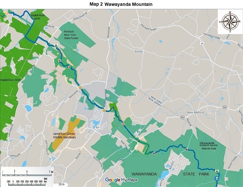
Hike east towards Wawayanda Mountain. In 0.5 miles began the ascent. The ascent becomes steep. In another 0.7 miles the turn off to Pinwheel Vista occurs (Stairway to Heaven Overlook Spur). Hike that 0.1 mile side trip to a spectacular view. In another 0.2 miles come to the summit of Wawayanda Mountain at 1340 feet. For the next several miles you will have some ups and downs, but mainly you will be on a high plateau. In another 1.7 miles pass Barret Road and High Breeze historic farm. Continue east for 1.1 miles past dirt Iron Mountain Road and cross Iron Bridge over the Doublekill. To your left is Wawayanda Hemlock Ravine Natural Area. The author of this description once saw three bears there in an hour. Two of them were gigantic. In another 0.9 miles pass the Wawayanda shelter. In another 0.1 miles come to the junction with the Hoeferlin Trail. |
|
26.1 |
Turn right on the blue blazed William Hoeferlein Trail for 0.3 miles to parking at the Wawayanda State Park headquarters. |
|
26.4 |
The hike ends at Wawayanda State Park headquarters. |
The NJ State Long Trail (NJSLT) is a 383-mile long hiking trail and greenway that will extend from the northern end of the state (High Point, the highest point in New Jersey), to the southern end (Cape May Point, at sea level).
For a printer-friendly version of this page, click here.