WAWAYANDA TRAIL SECTION
of the NJ STATE LONG TRAIL
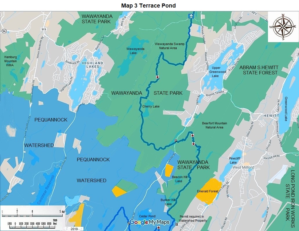
The Wawayanda Trail section of the NJ State Long Trail is 13 miles long. It has great views and superb hiking up and down slopes. It is made up of eight existing trails and three connecting dirt roads. It connects the Appalachian Trail and the Highlands Trail. There are now no plans to double blaze the routes blue, the color of the NJ State Long Trail. It is described by the New York New Jersey Trail Conference as a virtual route. It runs through Wawayanda State Park and a small portion of the Newark Watershed. This description should be read in conjunction with the accompanying map.
|
Miles |
Detailed Trail Data from North to South |
|
0.0 |
This trail begins at the intersection of the Appalachian Trail and the Hoeferlin Trail. Hike south, not north, on the blue blazed William Hoeferlin trail for 0.3 miles, to the Wawayanda State Park Office. The park office and parking are on Wawayanda Road 0.3 miles west of Warwick Turnpike. |
|
0.3 |
Hike south on the Hoeferlin Trail for 1.7 miles going over a rise at about 1300 feet above sea level and passing through a rhododendron forest; turn right or west on the yellow blazed Double Pond Trail for 0.9 miles, turn left or south, before it ends; you are now on the red blazed, Red Dot Trail. At 0.8 miles go up and over red dot peak at 1309 feet, continue south for another 1.0 miles; turn right or west for 0.2 miles on Cherry Ridge Road, blazed black and white. If you turn left or east on Cherry Ridge Road you will reach an early-out parking opportunity in 0.8 miles. From Cherry Ridge Road, turn left or south on Old Coal Trail for 2.8 miles, go over a ridge at about 1300 feet, pass Bearfort Waters, come out on Clinton Road; travel north for 0.1 miles. Park here. |
|
7.8 |
Hike east up a steep slope of 300 feet on Terrence Pond North Trail for 1.5 miles; there are several spectacular views at 0.9 miles and 1.3 miles from Bearfort Mountain on this hike; hike south on white blazed Terrance Pond Circular Trail for 0.4 miles, enjoy the views of the pond from great rock outcroppings; turn left or south on yellow blazed Yellow Dot Trail, hike south and south west for 0.7 miles; turn left or south east on red blazed Terrance Pond Red Trail for 1.5 miles. Come to unmarked dirt Stephens Road, hike east 0.4 miles on it to white blazed Hanks East Trail. Hike 0.2 miles further east on Stephens Road, where the Newark watershed authorizes parking for a fee. This parking is 0.2 miles west on Stephens Road from CR 513, Union Valley Road. |
|
12.3 |
From unmarked Stephens Road, hike 0.7 miles south west on Hanks East Trail inside the Newark Watershed to the Highlands Trail. |
|
13.0 |
This ends your hike on the virtual Wawayanda Trail from the Appalachian Trail to the Highlands Trail of thirteen miles. |
The NJ State Long Trail (NJSLT) is a 383-mile long hiking trail and greenway that will extend from the northern end of the state (High Point, the highest point in New Jersey), to the southern end (Cape May Point, at sea level).
For a printer-friendly version of this page, click here.