ASSUNPINK CREEK TRAIL SECTION
of the NJ STATE LONG TRAIL
The Assunpink Creek Trail is 29 miles long. Special highlights of this trail are numerous views of Assunpink Creek, dammed lakes along the creek, marshes near the creek, adjacent farmlands, historic sites, woodlands, and the hills in the Monmouth portion of the trail.
This trail is now divided into day hikes, because of the various places where private parcels prevent through-hiking. This description should be read in conjunction with the accompanying map. However, the map does not include the bypass routes, which are written into the description for any bold hikers who wish to through hike this route now. The existing trail on the map provides numerous opportunities for short pleasant hikes in the woods at this time. More of the Assunpink Creek Trail will be paint blazed blue in the future. The trail was first laid out in 2008.
MERCER COUNTY
|
Miles |
Detailed Trail Data from north to south |
|
0.0 |
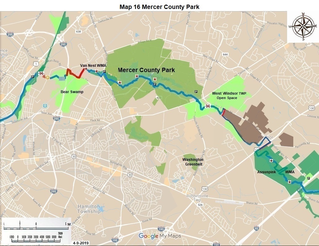
Trail begins 0.2 miles north of the Carnegie Road parking lot on the Delaware & Raritan Canal State Park next to US 1. There is parking for ten cars there. |
|
0.5 |
The Bear Swamp trail described here is owned by Hamilton Township and paint blazed blue. Go east for 0.1 miles turn left at the loop intersection; go 0.3 miles to the trail continuing east; go 0.1 miles to the swamp crossing. This crossing is often wet; it is also a beautiful place. Continue east another 0.1 miles to the bottom of the freeway; turn north for 0.2 miles to a great view of Assunpink Creek. |
|
1.3 |
Proceed 0.4 miles east on Bakers Basin Road-Youngs Road (CR 546); there are deer trails on the unclaimed private property on both sides of the road. The ten acre property south of Bakers Basin Road should be foreclosed on by Lawrence Township, dedicated to the hiking trail and greenway and transferred to the State or County. It has a good view of the creek. Go under the IS 295 Bridge and over the Amtrak viaduct; Bear Swamp Park East is to your right. |
|
1.7 |
The planned route goes 0.4 miles north through private land to Van Nest Wildlife Refuge. Part of this 38 acre property should be purchased by DEP for the trail and greenway. |
|
2.7 |
The trail running west for 0.6 miles on Van Nest Wildlife Refuge from Quakerbridge Road is part of the permanent trail. It has two good views of the Creek and is paint blazed blue. On the north east corner of Quakerbridge Road and Hughes Drive is a good Fish and Wildlife parking lot for twenty cars. |
|
3.3 |
Proceed generally east on excellent trails through Mercer County Central Park; there are numerous good views of the lake, fields, and woods. Follow the top of the dam and the bike path for 1.5 miles to the Marina parking area which has room for 20 cars. |
|
6.2 |
The planned permanent trail will veer to the east for 0.3 miles to Old Trenton Road (CR535); go south 0.1 miles to cross this busy road at the safest point at a stop light, immediately to the south of the “T” intersection with Robbinsville Road (CR 526). |
|
6.6 |
Enter West Windsor owned Open Space at the northeast corner of the intersection. This land is leased to a farmer; remain on the woods-cropped field edge during the growing season. This is pleasant hiking. At 0.3 miles there is a low point with a dirt road crossing to the next field. In another 0.1 miles the trail cuts north into low woodland along Assunpink Creek. Here hiking volunteers should recommend to West Windsor Township the driest route through the next 0.1 miles to the creek at a possible bridge site and then cut the route. West Windsor owns both the higher northern side and the lower southern side of Assunpink Creek here. Hike east on West Windsor open space for 0.3 miles to county owned land. |
|
6.9 |
The 2.0 miles north of the creek from here to Windsor Village, the planned route, cannot be through hiked at this time even though 1.9 miles of it is owned by the county, which supports the trail. Robbinsville Township’s Tatum Park on the south side of the Creek and Fishing Park on US 130 are part of the Greenway. A five acre property between Assunpink Creek and Windsor Road should be purchased by the county and dedicated to the Assunpink Creek Hiking Trail. There is parallel parking for five cars on Main Street in Windsor Village. |
|
9.2 |
The next 0.3 miles of the planned route are north on Main Street through historic Windsor Village on sidewalks. The bypass route joins the planned route here. |
|
9.5 |
On the reunited route go another 0.2 miles east on Windsor Road to US 130; cross at the light; go south for 0.5 miles on the east side of US 130 to the large Fish and Wildlife parking lot. |
|
10.2 |
The Assunpink Creek Wildlife Management Area is an incredibly rich biological area containing most species of wildlife native to central New Jersey. It is a very desirable place for hiking, bird watching, hunting, fishing, dog walking, and all forms of nature appreciation. Everyone should respect the rights of other users. |
|
11.7 |
From the broken dam site at the center, follow Beaver Creek southwest for 100 yards; continue southwest for 0.3 miles on the edge of a field, turn left or east on the same field edge for 0.2 miles. Watch for hunters and beaver sign in this area; go straight into the woods for 0.3 miles, crossing two more side creeks, continue east for 0.1 miles on a field edge take the side trail 100 yards south for a good view of the marsh; go straight into the woods, follow the blue paint blazes for 0.3 miles with several turns and crossings of three more side creeks. Just before the metal road barrier on Windsor Road turn left for 100 yards to reach the road. The trail goes east here. |
|
12.9 |
0.2 miles to the west is good parking at the historic Windsor House parking lot for 20 cars. This parking lot is on Windsor Road 1.6 miles south east of the US 130 light. Continuing east on the trail, repeat the 0.2 miles from the parking lot to the Turnpike bridge. Go east over the Turnpike 0.3 miles to Allens Road. Here the permanent trail and bypass route diverge. |
|
Miles |
Detailed Trail Data from north to south |
|
13.1 |
The permanent route now runs one hundred yards north on Allens Road; turn east to Assunpink Creek and follows it 0.3 miles on a good dear path; the route then runs around an alternate creek channel which is dry most of the time; go another 0.2 miles along the creek. This creek walk is very enjoyable. The blue blazing ends here. The next 0.6 miles are on three private land parcels, which cannot be hiked now. DEP should purchase a strip along the creek from these owners for the trail and greenway and to unite the two halves of the Assunpink Creek Wildlife Management Area. |
|
14.5 |
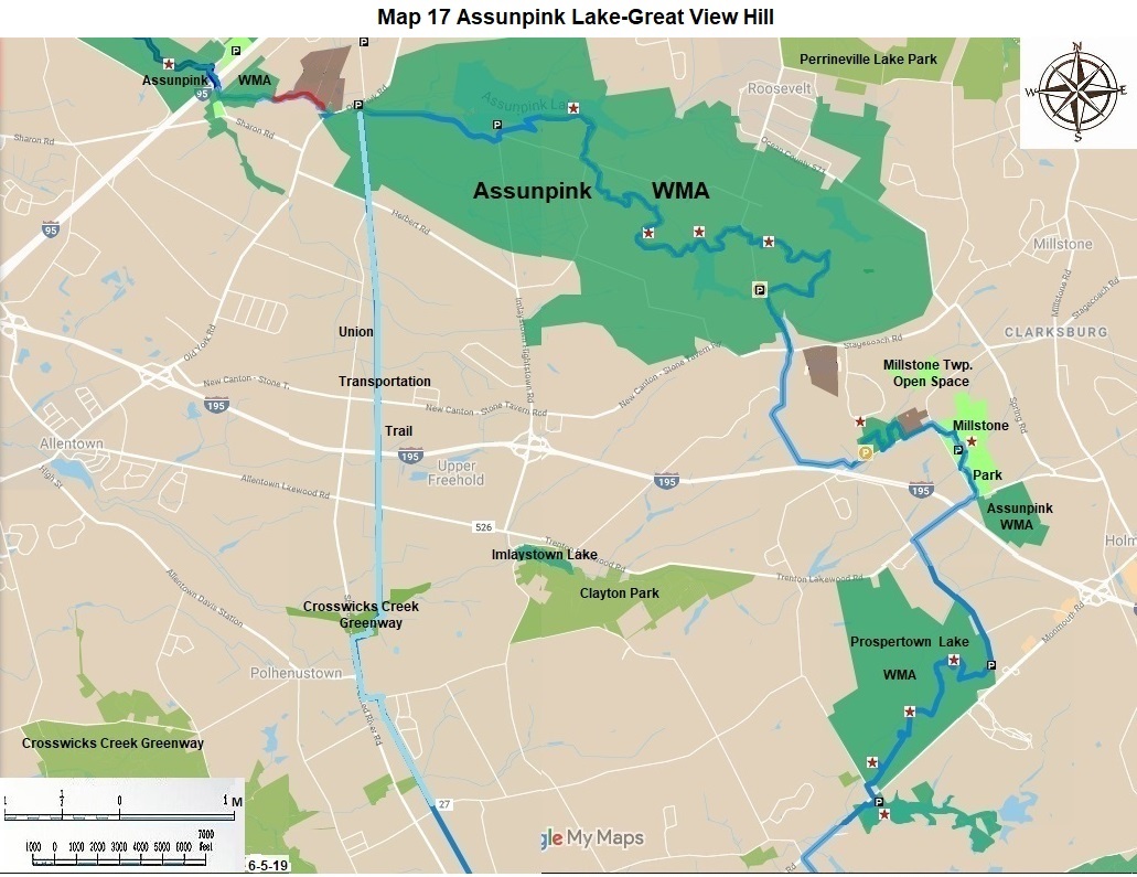
This Fish and Wildlife Parking area has room for six cars. It is 0.2 miles north of the Assunpink Creek Bridge on CR 539. County Route 539 divides the Assunpink Creek Trail and Greenway into a Mercer and a Monmouth portion. In Mercer County we have seen how eight private properties prevent through hiking. |
MONMOUTH COUNTY
|
14.5 |
The trail runs through mostly rural areas in western Monmouth County. There are two large Wildlife Management Areas in the northern and the southern portions of western Monmouth County with excellent trails within them. They are the Assunpink Creek WMA and the Prospertown Lake WMA. There is a great municipal Park between them named Millstone Park. A temporary route has been developed to connect these three areas for those wishing to through hike this area. It is on paved roads. |
|
15.9 |
From the parking lot go back south 0.1 mile to the road intersection; turn left 135 degrees, not 90 degrees; continue along the lakeshore for another 1.0 miles on the winding road; turn right or south, pass the model airplane field, continue south for 0.3 miles to a major left turn within the Wildlife Management Area. |
|
17.2 |
From here we go through a series of fields. During the December, January and February firearm season for deer hunting, all other users of the Area should wear hunter’s orange and be very careful, if they choose to be in the woods at this time. |
|
18.0 |
Take a non-drivable left turn up the hill for 0.1 mile; turn right for 100 yards to Hawk Hill. This is the highest point on the NJ State Long Trail between Riegelsville and the Cape May Lighthouse. It is 310 feet high. Retrace the 100 yards and proceed east along the high ridge line on a good trail for 1 mile. Turn right at a dirt road useable by vehicles, but usually gated closed. |
|
18.8 |
This field or parking area has room for twenty cars. It is 0.6 miles north of CR 524. A side trail to the west leads to another nice lake in 0.1 miles. In the future purchase of parts of three private properties south of here could eliminate a portion of the route on paved roads. |
|
19.7 |
From the parking lot continue south for 0.6 miles, hike out of the WMA; come to busy CR 524, Stagecoach Road; cross it. Continue south on paved Chambers Road for 1.0 miles, enjoy this fine hilly and wooded area. Before Interstate 195, turn left on Chambers Road for 0.5 miles, coming to the interstate crossing on Yellow Meeting House Road. There is a possible shortcut from here to Prospertown Lake WMA; an equestrian group in Millstone Township is working on it. |
|
21.8 |
We recommend continuing east for 0.2 miles on Yellow Meeting House Road and turning into a noncontiguous portion of Assunpink Creek Wildlife Management Area with a parking lot. The trail runs adjacent to woods on two fields. Each field is 0.1 miles north 0.2 miles east and 0.1 miles south, between the fields cross a branch of Doctors Creek, near a dam. From the first field you can bushwhack north up a hill and reach 230 feet of elevation near the private properties on Cheryl Lane. Travel east on Yellow Meeting House Road for another 0.2 miles. |
|
23.1 |
At Red Valley Road, hike straight into the field ahead of you into Millstone Municipal Park. Much of this fine park has been developed by 2020. Hike 0.3 miles to the main activity center, which has a parking area for twenty cars. |
|
24.1 |
Turn right on busy CR 526, at 0.2 miles; cross IS 195 on a narrow sidewalk. At 0.6 more miles turn left on paved Old Noah Hunt Road. Go south for 1.2 miles on this road to the eastern parking lot for Prospertown Lake WMA. |
|
26.1 |
This parking lot has parking for ten cars. Go west over the parking barrier for vehicles, hike 0.3 miles; hike north 0.2 miles along the bottom of the high hill, hike 0.1 miles up and down the hill on the only route to the top; it is 216 feet high. Continue west for 0.1 miles turn left, continue 0.2 miles south on the bottom of the hill. Note the old foundations for buildings. Turn right or south west, go 0.4 miles; at an intersection turn right, go 0.1 miles, cross Ivanhoe Creek. Note the ponds here. The trail turns south for 0.2 miles and crosses Ivanhoe Creek again. Turn west for 0.4 miles; then hike north through a field and back for 0.1 mile to the bluff for a view of Ivanhoe Creek. In the future the one mile bluff should be cut, and paint blazed for a spectacular hike, overlooking the valley below. Then hike another 0.4 miles west. Turn left when you reach paved Millers Mill Road; go 0.2 miles south to the large parking lot at Prospertown Lake on CR 537 or Monmouth Road. |
|
28.9 |
The view of Prospertown Lake and the distant view of the Great Adventure roller coasters is a great ending for the 29 mile long Assunpink Creek Trail and Greenway. This parking lot is also the beginning for the 34 mile long Northern Pinelands Trail running south from here. Both trails are part of the NJ State Long Trail. This lot has parking for 20 cars and is three miles west of IS 195 and six miles east of CR 539. |
The Assunpink Creek Trail was designed and mapped in 2008 by David Mattek and Frank Pearce.
The NJ State Long Trail (NJSLT) is a 383-mile long hiking trail and greenway that will extend from the northern end of the state (High Point, the highest point in New Jersey), to the southern end (Cape May Point, at sea level).
For a printer-friendly version of this page, click here.