DELAWARE & RARITAN CANAL STATE PARK SECTION
of the NJ STATE LONG TRAIL
The Delaware & Raritan Canal trail is 70 miles long. Thirty seven miles of it are part of the NJ State Long Trail. Hiking along the Delaware River and along the slowly flowing canal waters is a pleasant and joyful experience. The State Park runs through beautiful woods and farms in central New Jersey. It also runs through historic and tourist-attractive boroughs in Hunterdon County, and the historic capitol city of the State, Trenton. The preserved locks along the canal are relics of its history. Construction of the canal began in 1830; it became a State Park in 1974.
There are no plans to blaze the canal blue, the color of the NJ State Long Trail, because no hiker, biker or equestrian can get lost anywhere along its route. This description and the accompanying map can be supplemented by the State Park brochure, which information can be taken from the internet.
The greenway concept used here is the string-of-pearls concept. The Canal State Park is usually narrower than 300’. However, we hope that it will be widened in the future. The pearls now include two Wildlife Management Areas, two State Preserves, several municipal parks, seven major bulges in the Delaware, Delaware & Raritan Canal State Park, Ted Stiles County Preserve, two portions of Washington Crossing State Park, and Cadwalader Municipal Park. Some of these open space pearls have good internal trails to hike from the D&RC State Park. Others have deer trails only used by hikers and other locals.
|
Miles |
Detailed Trail Data from north to south |
|
|
0.0 |
|
|
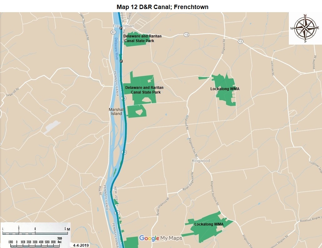
2.6 |
Hike south. In 1.1 miles pass the Kingwood boat launch. Continue south for another 6.1 miles, pass Point Pleasant; enjoy the views, including the views of the Delaware River. |
|
9.8 |
|
|
|
11.5 |
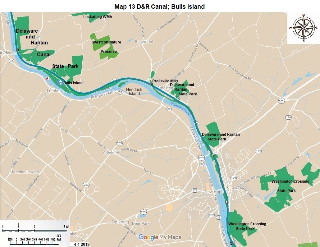
Continue hiking south 2.8 miles to Prallsville Mills. This is another nice stop. You can view the locks, sawmill, gristmill, and linseed oil mill. |
|
|
14.3 |
Continue hiking south for 0.5 miles to historic Stockton with its bridge to Pennsylvania. In another 2.3 miles pass Jimson Farm. In another 1.3 miles come to historic Lambertville. There are multiple good restaurants, historic houses, a bridge to Pennsylvania and the Lambertville locks. |
|
18.4 |
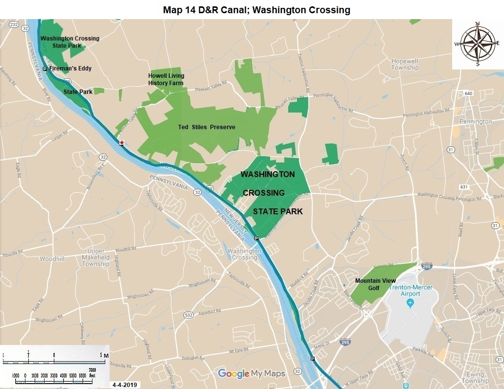
Hike south 1.4 miles to Firemen’s Eddy. The eddy is the most dangerous part of this portion of the Delaware River. There are pleasant internal trails through fields at this stop. There is a view of the Delaware rapids from this spot. You enter Mercer County here. Hike another 1.8 miles south to the ruins of an old railroad bridge, still spanning one half the Canal. Continue hiking south. In another 2.2 miles pass through the pleasant residential community of Titusville. In another 1.2 miles come to Washington Crossing State Park. |
|
25.0 |
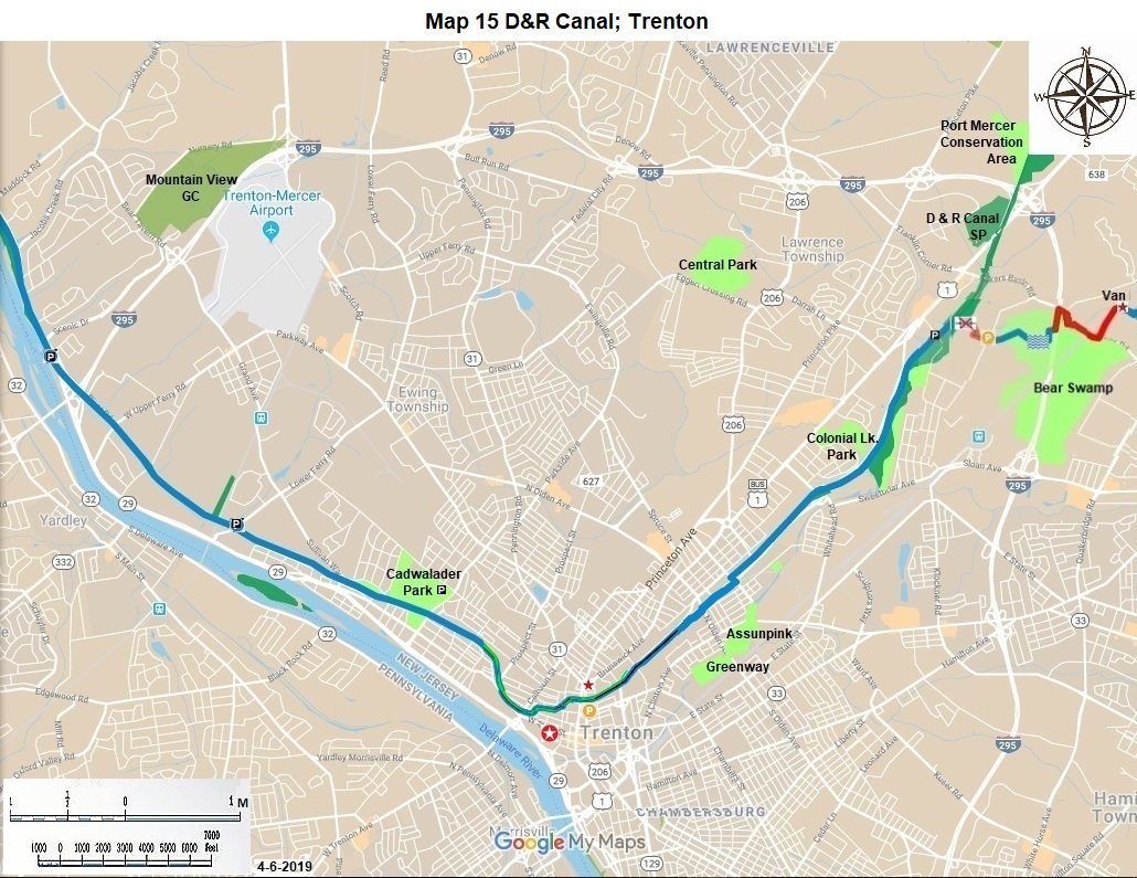
George Washington made his famous crossing of the Delaware River here on Christmas Night in 1776. There is a pedestrian bridge here to Washington Crossing State Park in New Jersey, with its excellent internal trail system, and a road bridge to the Canal State Park in Pennsylvania. |
|
29.4 |
Continue hiking southeast on the bucolic canal for 1.7 miles to Cadwalader Park, a fine central park for the City of Trenton. It is surrounded by stately old homes. There is parking here. Continue south east along the canal for 1.3 miles to Calhoun Street and the Calhoun Street Bridge. Continue east along the canal 0.6 miles to Broad Street (US 206) in downtown Trenton. There is street parking here. |
|
33.0 |
Walk one block north on Broad Street to observe the Battle Monument. Walk three blocks south on Broad Street to State Street. Walk west two blocks on State Street to enter the State Capitol building. Observe the Governor’s Office and the two chambers of the State Legislature. There is parking here in the underground garage. The Old Barraks is one block west on Willow Street. |
|
34.6 |
Continue hiking north East alongside the open canal. Pass Whitehead road in 1.0 miles. Come to parking at Carnegie Road in another 1.7 miles. There is parking here just off US 1. For the present this is the practical end of the 37.3 mile hike on the Delaware and Raritan Canal State Park part of the State Long Trail. |
|
37.3 |
It is hoped that in the future, after property acquisition and bridge building, the Assunpink Creek Trail will intersect with the Park Canal Trail 0.2 miles north of here. |
|
37.5 |
Final length with hoped-for 0.2 addition. |
The NJ State Long Trail (NJSLT) is a 383-mile long hiking trail and greenway that will extend from the northern end of the state (High Point, the highest point in New Jersey), to the southern end (Cape May Point, at sea level).
For a printer-friendly version of this page, click here.