NORTHERN PINELANDS TRAIL SECTION
of the NJ STATE LONG TRAIL
The Northern Pinelands Trail is 37 miles long. It has numerous notable points, including some high hills and numerous good views of waterways, especially in the Colliers Mills and Whiting Wildlife Management Areas and in Crossley Preserve. This description should be read in conjunction with the accompanying map. The Northern Pinelands trail is now being paint blazed blue.
|
Miles |
Detailed Trail Data from North to south |
|
0.0 |
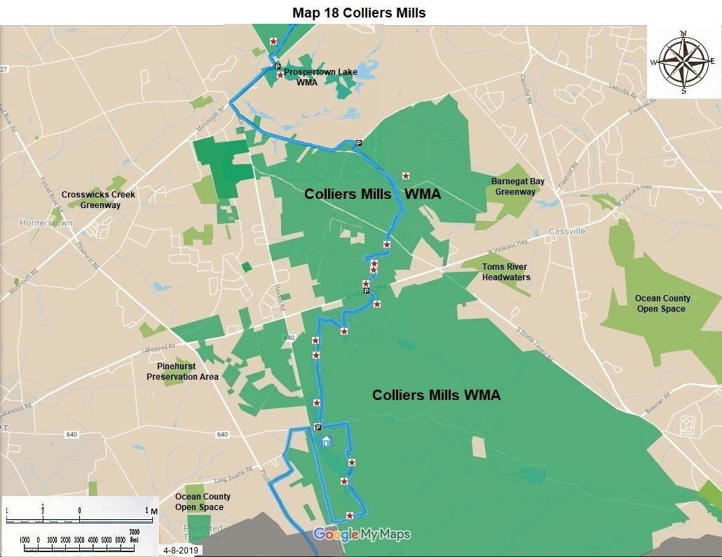
The trail begins at the Prospertown Lake parking lot with great views of the lake and the rollercoaster to the east. It has parking for more than twenty cars. The parking lot is also the southern end of the Assunpink Creek Trail. The lot is on CR 537, five miles west of Interstate 195 and six miless east of CR 539. Hike west for 0.8 miles on heavily travelled CR 537 to Hawkins Road. Turn left for 0.2 miles on CR 640. Turn left on Reed Road for 1.5 miles. It was once blacktopped. Pass several residences and one campground. At a v turn, hike right for 0.1 miles on the trail to the trail. Go left at the v for 0.1 miles until you come to a place where ten cars can be parked. |
|
2.5 |
From here hike 0.1 miles south. Go south east for 0.7 miles to a view of a pond to your left; go south and south west for 0.8 miles to a five point intersection of dirt roads at stump road. |
|
4.1 |
Go west through this intersection for 200 feet; turn south for 0.2 miles hike up to a ridge line with a 170 foot hill; stay on the ridge line for 0.2 miles; go down off the ridge line to the right for 0.2 miles to a narrow dirt road, turn left, continue for 0.3 miles; turn left again or south on a trail paint blazed red, follow this winding dirt trail up and over hills, the highest of which is 193 feet, continue for 0.5 miles; come down the last hill to a dirt road at a pond, cross the dam; turn south for 0.1 miles to CR 528. |
|
6.7 |
On the south side of CR 528 next to the bogs reach parking area 10 with parking for twenty cars. This parking area is 2.5 miles east of CR 539. |
|
8.1 |
Hike 1.4 miles south along an area with many lake and pond views. The first pond is to the left about 0.1 miles. Hike past several blockades for vehicles. You are now on Colliers Mills Road about one block east of parking area nine, at another place for parking many vehicles; hike east on dirt Colliers Mills Road for 0.5 miles to a big tree. At the end of the fields to your right, turn right and hike for 0.4 miles along the field edge to the east, avoid the gun range, airfield, and equipment center to your west; reach the beginning of the dam. |
|
10.4 |
Hike south along the large dam for 0.5 miles; continue south for another 0.5 miles, crossing another dam; turn west for 0.5 miles; turn right or north on dirt Hawkins Road for 1.3 miles. |
|
13.2 |
You are now at parking area at the corner of Hawkins Road and Colliers Mills Road. There is parking for twenty cars here. This is the main entrance to Colliers Mills Wildlife Management Area. The parking area is 0.8 miles east of CR 539 on paved Colliers Mills Road. |
|
Miles |
Detailed Trail Data from North to south |
|
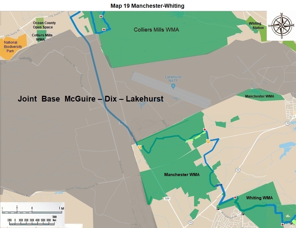
15.1 |
For four miles going south stay on the grass strip east of CR 539 through the Joint Military bases. |
|
19.1 |
Parking area 8? is 0.2 miles south of the bases. It has room for parking 20 cars parallel on CR 539. |
|
22.1 |
Go east 0.1 miles on Horicon Avenue; make a right turn through a housing development for 0.2 miles; turn west or right onto Central Avenue for 0.4 miles; follow Central Avenue around the curve south for 0.6 miles. Turn right or west into the South Manchester WMA; Proceed 1.3 miles on a dirt road that returns to Central Avenue; continue south on Central Avenue for 0.3 miles to NJ 70. Cross at the stoplight; hike south on Manchester Boulevard for 0.7 miles. |
|
Miles |
Detailed Trail Data from North to south |
|
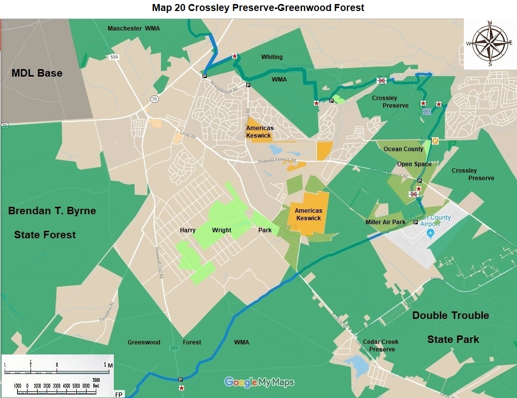
25.5 |
Parking Area 7 at Manchester Boulevard and Wrangel Road and the RR tracks has parking for three cars. The trail in the Whiting Wildlife Management Area is paint blazed blue. |
|
28.9 |
This is the dividing point for the permanent trail and a temporary bypass route (described below). Turn left into Crossley Preserve, go 0.3 miles; turn right at turn, go 200 yards to parking area five. Parking area five has room for 20 cars. It is at the cul-de-sac for Congasia Road. |
|
28.9 |
The bypass route for the missing bridge at Michaels Branch begins 0.3 miles west of the cul-de-sac for Congasia Road. Turn left or south for the temporary route at the reservoir; go 0.1 miles enjoy the reservoir; south of the reservoir there is parking for five cars. Go 0.5 miles south and 0.2 miles east within the Whiting Wildlife Management Area. Hike another 0.5 miles south on Congasia Road; turn left or east on the utility line for 1.0 miles turn left on Township line road, hike 0.3 miles to parking area four and to another entrance to Crossley Preserve. Parking area four has parking for twenty cars at the end of the paved portion of Township Line Road. |
|
31.8 |
The bypass route and the route to the permanent route proceeds up dirt Township Line Road within the Preserve for 0.4 miles; turn left and hike another 1.1 miles to the merger of the two routes. The temporary route is 5.5 miles long. |
|
30.8 |
From the merger of the two routes in Crossley Preserve, go east for 0.6 miles; go north for 0.2 miles; go east for 0.2 miles. The trail goes another 0.1 mile east in the Preserve. However, there is an interesting bridge 0.1 mile north of the trail on private land. It appears to have been constructed by outdoor recreational vehicle users. Go 0.1 miles south east to return to the trail. |
|
31.9 |
At this intersection turn right or south west in Crossley Preserve on Township Line dirt road. Watch for snakes here. Hike 0.4 miles south. There is a confusing mix of alternate routes here be careful. Make a sharp left hand turn to the north east. Then immediately turn right to the south east. Proceed for 0.5 miles. View multiple old quarries along the eastern side of this dirt road from colonial mining operations. Enjoy. Come to Oxbow Creek, cross another rough bridge; continue to a maintained historic trail in 0.1 miles. |
|
32.9 |
To stay on the main trail make a sharp left here; proceed 0.5 miles north and east by attractive waterways; turn south go 0.7 miles pass a subdivision on your left; continue to the utility line. If you go straight at the sharp left, proceed for 0.5 miles on an old narrow gage railroad with old ties on your route to the same utility line. |
|
34.1 |
Go 100 yards east on the utility line; turn south on dirt Crossley Road for 0.8 miles. Leave Crossley Preserve after 0.4 miles here and enter Ocean County Natural Trust Lands for 0.4 miles. Reach parking area 2. |
|
34.9 |
Parking area 2 is on the north side of CR 530 about 0.5 miles east of the stop light on Mule Road. It has parking for ten cars. |
|
35.5 |
This is parking area 1 for twenty cars. It is 1.0 miles south of the stoplight at CR 530 and Mule Road. |
|
36.5 |
This is parking area 0. It has parallel parking for ten cars. It is 1.7 miles south of the previously mentioned stoplight. |
The Northern Pinelands Trail was designed and mapped in 2011 by David Mattek and Frank Pearce.
The NJ State Long Trail (NJSLT) is a 383-mile long hiking trail and greenway that will extend from the northern end of the state (High Point, the highest point in New Jersey), to the southern end (Cape May Point, at sea level).
For a printer-friendly version of this page, click here.