PROPOSED DELAWARE & RARITAN CANAL STATE PARK EXTENSION
of the NJ STATE LONG TRAIL
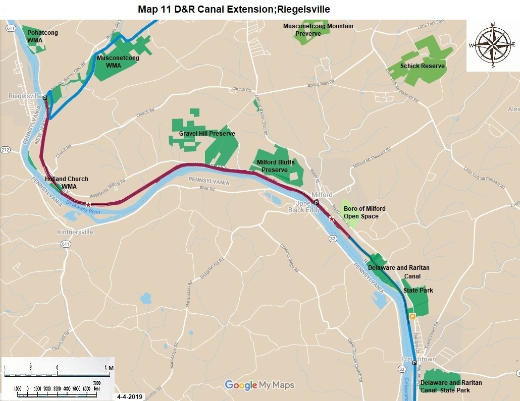
This proposed extension of the State Park is 7.4 miles long. It is now owned by the Black and Decker Railroad. It features great views of the Delaware River, the rural countryside in Hunterdon County, and East Riegelsville and Milford Borough. The accompanying map portrays the route in red to discourage its use. Hunterdon County has also expressed an interest in having a county park on this portion of the Delaware River. The proposed extension of the State Park is a part of 378 mile long NJ State Long Trail.
|
Miles |
Detailed Trail Data from north to south |
|
0.0 |
The proposed trail segment cannot be hiked now because it is private property; this section describes the temporary bypass route, which is 10 miles from the small Fish and Wildlife parking lot next to the Riegelsville Bridge south to Frenchtown Bridge in Frenchtown. The first four and one half miles is on CR 627, which is a two lane paved road. The next two miles on CR 627 is a one lane paved road with traffic moving in each direction. Please be careful hiking here. The final portion is on residential streets in Milford, where there is parking. |
|
6.5 |
The next three and one half miles are back on paved two lane CR 627, until 12th Street in Frenchtown. There is often parking here for two cars on a residential street. There is additional parking in downtown Frenchtown. This ends the ten mile temporary bypass. |
|
0.0 |
Once the railroad is purchased for the proposed trail, the route will begin at the same small Fish and Wildlife parking lot next to the Riegelsville Bridge to Pennsylvania, referenced above. In 0.2 miles cross the railroad viaduct over the Musconetcong River and come to the large Fish and Wildlife parking lot. The future route follows the dirt repair road for the railroad for 5.5 miles. The railroad does not use any part of this track for trains any longer. It does send 10’ by 10’ carts powered by lawn mower engines down the rails several times a year to Milford maintaining the railroad. At 2.8 miles pass the Gilbert Point power plant of Public Service. There are great views of farms and hills both before and after this point. At five miles the route is close to the river for one mile. At 6.0 miles you are directly below the Milford Bluffs. Look up to enjoy them. This last mile has no repair road next to the tracks. You have to walk on railroad ties. At 6.5 miles stop for lunch in Milford. There is parking here. |
|
6.5 |
There is a railroad repair road next to the railroad along the next stretch. At 0.6 miles cross the Hakihokake Creek railroad trestle. For the next 0.3 miles stay on the railroad repair road through property on both sides of it owned by the abandoned paper plant to your left. The plant built a chain link fence to prevent access from the well maintained State Park trail beginning here. |
|
7.4 |
The next 2.6 miles is part of the State Park now. |
The NJ State Long Trail (NJSLT) is a 383-mile long hiking trail and greenway that will extend from the northern end of the state (High Point, the highest point in New Jersey), to the southern end (Cape May Point, at sea level).
For a printer-friendly version of this page, click here.