HIGHLANDS TRAIL SECTION
of the NJ STATE LONG TRAIL
The Highlands Trail of New York and New Jersey is a project of the New York New Jersey Trail Conference and is 168 miles long, 122 miles of which is in New Jersey. The southern 96 miles of the Highlands Trail is co-aligned with the NJ State Long Trail (NJSLT) The Highlands Trail is marked in teal blue diamonds. The only marking for the NJSLT for these 96 miles are the teal blue diamonds. Much like the NJSLT, the Highlands Trail is as varied as the terrain it passes through. It follows abandoned railroad beds, crosses open fields, traverses’ mountains, and crosses numerous creeks. Where the trail follows paved roads, the utility poles are blazed. Where the Highlands Trail is co-aligned with another trail, both trail blazes are displayed.
The descriptions and maps of the 96 miles of the southern portion of the Highlands Trail contained here are to provide an overview of the HT within this overall description of the NJ State Long Trail. For more detailed descriptions and maps go to the Highlands Trail Guide within the website of the New York New Jersey Trail Conference. https://www.nynjtc.org/book/highlands-trail-guide
The developers of the NJ State Long Trail recommend that public and semipublic agencies attempt to buy property to take the Highlands Trail, off-road wherever possible. In this way, the greenway concept will be advanced, as the string of pearls approach described in the main NJSLT page.
Generalized Trail Data, From North to South
Highlands Trail New Jersey 1 (part); Hanks East Trail to NJ Route 23
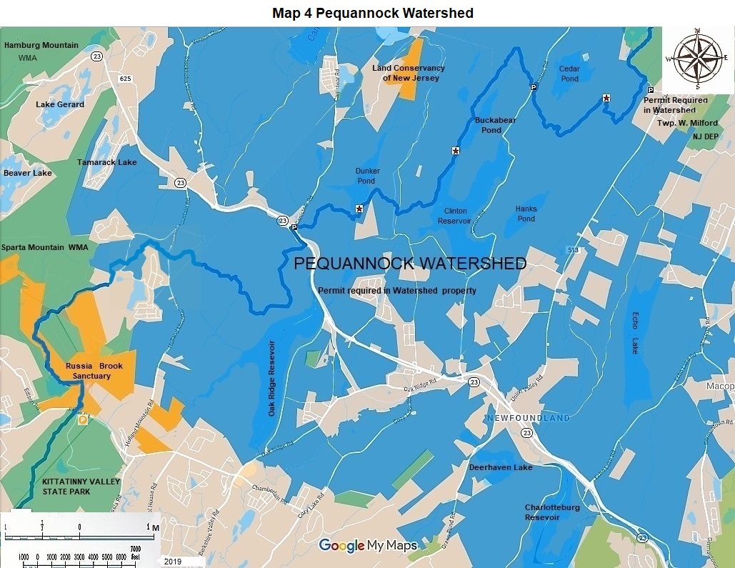
The 7.2 miles of the Highlands Trail and the 0.7 miles of Hanks East are in the Newark Watershed. A permit is required to park and hike in the Newark Watershed property. Parking is at Hanks East and Stephens Road, which is 0.1 mile north of CR 513, Union Valley Road in West Milford. Hike 0.7 miles south on Hanks East to the Highlands Trail. Turn right or west on the Highlands Trail at mile 26.2. At 26.7 miles pass the Bearfort Ridge Fire Tower. Continue west, at 28.6 miles cross Clinton Road. There is Newark Watershed permit parking here. Continue hiking south west to mile 33.4. There is additional Newark Watershed parking here at NJ 23 and Canister Road. Cumulative miles on the Highlands Trail as part of the NJ State Long Trail-7.2.
Highlands Trail New Jersey 2; NJ 23 to NJ 181
This 17.4 mile hike is almost completely on wonderful public lands. The lands are Newark Watershed (permit required), Sparta Mountain Wildlife Management Area, Russian Brook Sanctuary, an Audubon property, Kittatinny State Park, Mahlon Dickerson County Preserve, Rockaway River Wildlife Management Area, and Camp Jefferson Municipal Park.
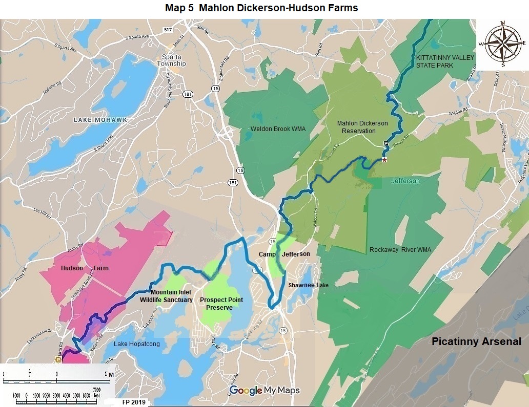
The north parking area is at 11.5 miles in Mahlon Dickerson County Reservation. This parking area is on Weldon Road 6 miles north of SR 181. Continue hiking south through woods to Weldon Road at 16.7 miles. Reach SR 181 by hiking south on Weldon Road at 17.4 miles. Cumulative miles on the Highlands Trail as part of the State Long Trail-24.5.
Highlands Trail New Jersey 3; NJ 181 to US 206
This 12 mile section is on Prospect Point Municipal Preserve, Hopatcong Municipal Preserve, Lubbers Run Preserve, Byram Municipal Park, private property, and roads. At mile 9.7 there is parking at Byram Township Intermediate School on Mansfield Drive, 0.35 miles east of CR 607. This hike ends at US 206. In 2018 there was a rerouting which shortened this hike a little. Cumulative miles on HT- 37.1.
Highlands Trail New Jersey 4; US 206 to Mine Hill Road
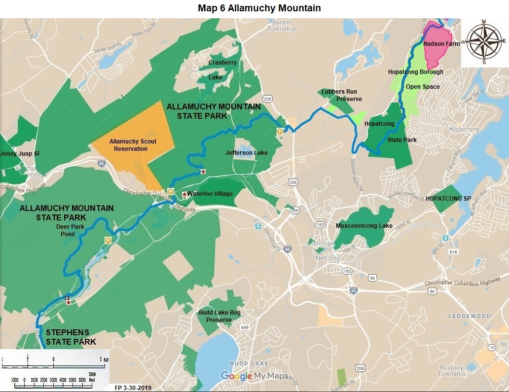
This great 10.5 mile hike is primarily in Allamuchy Mountain State Park and Stephens State Park. At 0.2 miles there is parking on High Glen Drive near US 206. There was a rerouting here in 2019. At 7.5 miles pass the historic Saxton Falls area.
At 8.2 miles there is parking in Stephens State Park near CR 604, Waterloo Road. Continue south to Mine Hill Road, at 10.5 miles. Cumulative miles on HT-47.6.
Highlands Trail New Jersey 5; Mine Hill Road to Schooley’s Mountain Park
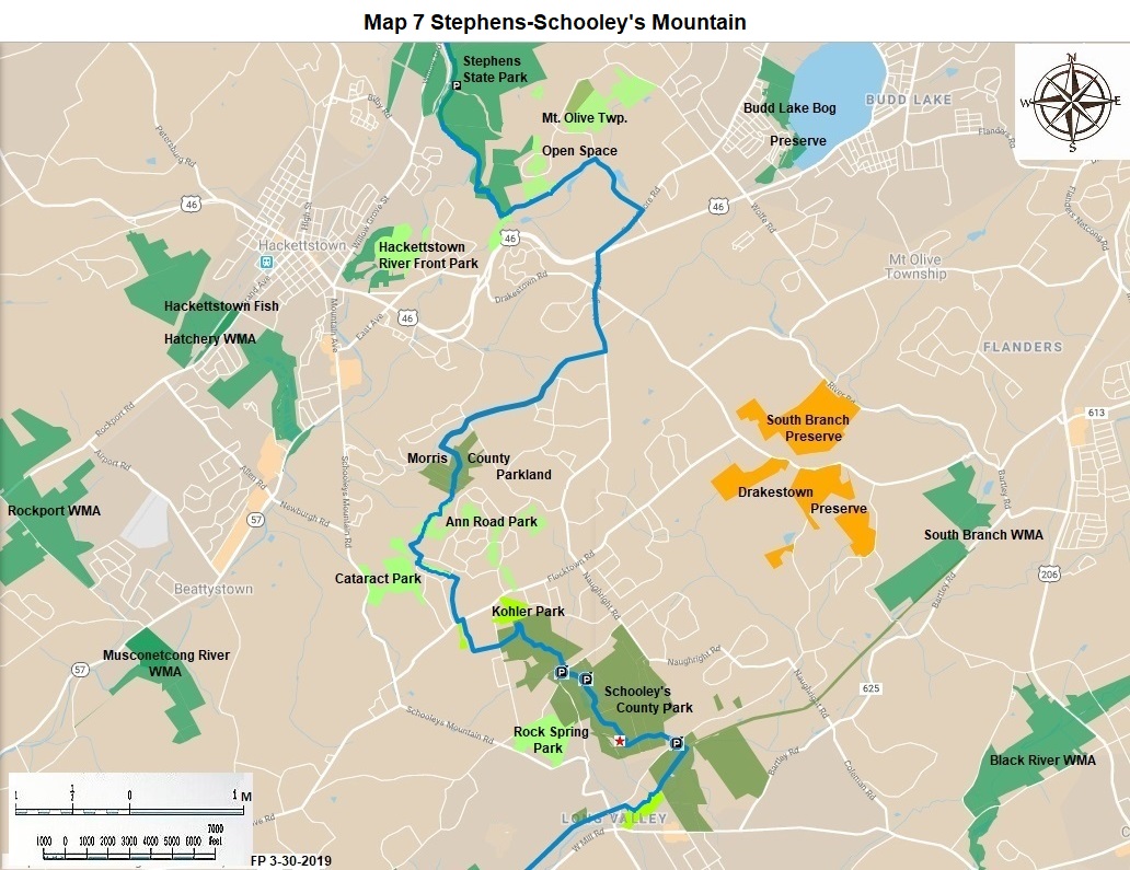
This 8.1 mile hike passes through fields, woods, and streams. Morris County’s Schooley’s Mountain Park is the high point of the hike. Parking is at mile 8.1 inside the park on East Springton Road near NJ 24. Cumulative miles on the HT-55.7
Highlands Trail New Jersey 6; Schooley’s Mountain Park to Voorhees State Park
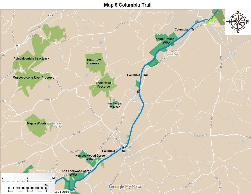
This 12.2 mile hike goes through Schooley’s Mountain County Park, the Morris County and Hunterdon County maintained portion of the Columbia Rail Trail, Ken Lockwood Gorge WMA, and Voorhees State Park.
At 10.8 miles the rail trail crosses the Raritan River on a wonderful rail trestle with a good view. Immediately thereafter turn right and make a major ascent on switchbacks through the WMA. Reach parking in Voorhees State Park at 12.2 miles on CR 513. Cumulative miles on the HT-62.9
Highlands Trail New Jersey 7; Voorhees State Park to Spruce Run Recreation Area
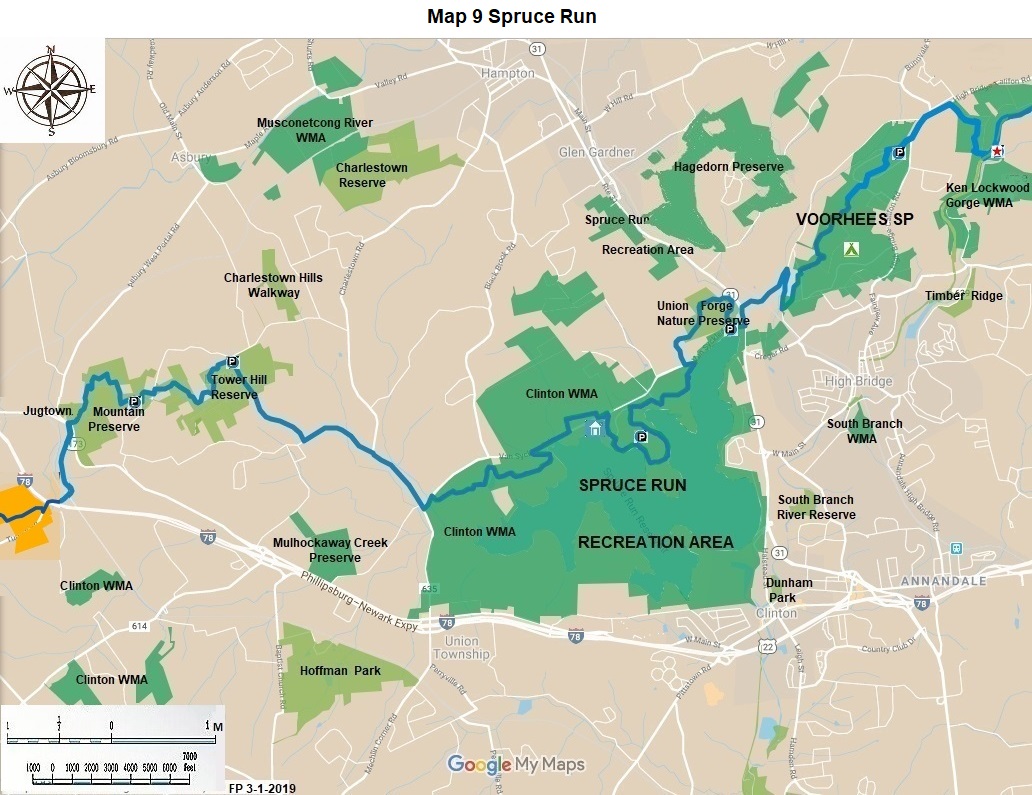
Hike south through the park; at 1.7 miles pass the observatory. Hike some marked roads. At 3.1 miles enter Union Furnace Preserve, a Hunterdon County Park. At 4.2 miles enter Spruce Run Recreation Area; at 5.1 mile enjoy the lake activity center. Parking for the activity center is on CR 539 about 1.2 miles west of NJ 31. Cumulative miles on the HT-73.0.
Highlands Trail New Jersey 8; Spruce Run Recreation Area to NJ 173
This 7.6 mile hike runs through several open space area. Hike west; leave the Recreation Area; pass through the Clinton WMA. At 2.8 miles turn north on Charleston Road (CR 635). At 5.0 miles enter Tower Hill County Reserve.
At 6.4 miles come to parking within the Jugtown Mountain Preserve, another County Park. This parking is at Mine Road 0.5 miles north of NJ 173. At 7.6 miles come to SH 173. Cumulative miles on the HT-80.6.
Highlands Trail New Jersey 9; NJ 173 to Dennis Road
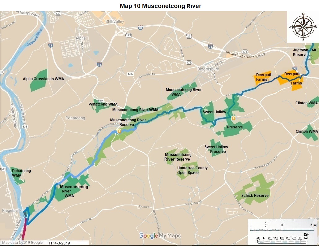
Hike south on Tunnel Road for 1.0 miles. Pass under the I-78 overpass. Parking is on the right side of the road, a little way past the overpass. Turn northwest immediately into Deerpath Sanctuary, a New Jersey Audubon property. Continue west through the sanctuary and on roads until mile 3.5 to Sweet Hollow Preserve, a New Jersey Natural Land Trust Property. Enter the Musconetcong Gorge Preserve, another County Park, at 6.0 miles. Enjoy some rugged rock and slopes here. Parking is available on Dennis Road near CR 519. Cumulative miles on the HT-90.3
Highlands Trail New Jersey 10 Dennis Road to the Riegelsville Bridge
In 2019 the Highlands Trail leadership co-blazed the 2.2 miles of the County orange Waterfall Trail in Musconetcong Preserve, teal blue the color of the Highlands Trail. Also 1.6 south Bellis Rd. It also blazed 1.2 miles of Mt Joy Road south, 0.5 miles of CR 627 miles north west, and 0.3 miles of Riegelsville Warren Glen Road south west to the Riegelsville Bridge and the State line.
This completes the blazed portions of the Highlands Trail through two states. There is a small Fish and Wildlife parking lot right next to the bridge. It is the planned meeting place for the Delaware and Raritan Canal State Park and the Highlands Trail after the purchase of an important property. Cumulative miles of the Highlands Trail on the NJ State Long Trail: 96 miles.
The NJ State Long Trail (NJSLT) is a 383-mile long hiking trail and greenway that will extend from the northern end of the state (High Point, the highest point in New Jersey), to the southern end (Cape May Point, at sea level).
For a printer-friendly version of this page, click here.