SOUTHERN PINELANDS TRAIL – PART 2
of the NJ STATE LONG TRAIL
Cape May County
The section of the NJ State Long Trail through Cape May County is 39 miles long. It goes through wonderful natural lands and fine developed lands on a 100’ wide bicycle trail for much of its length. It uses the string of pearls process to pass through or adjacent to major open space areas, including, Peaslee WMA, Belleplain State Forest, the Cape May National Wildlife Refuge (Great Cedar Swamp Division), Beaver Swamp WMA, Lizard Tail Swamp WMA, Cape May County Central Park and Zoo, Clarence Davis Municipal Park, the Cape May National Wildlife Refuge again, Cape Island WMA, Cold Spring Village, Higbee Beach WMA, and Cape May Point State Park.
The NJ State Long Trail in Cape May County begins at the Cumberland County Line in Peaslee WMA and continues to parking in 0.3 miles on CR 550, Weatherby Road.
|
Miles |
Trail Data North to South |
|
0.0 |
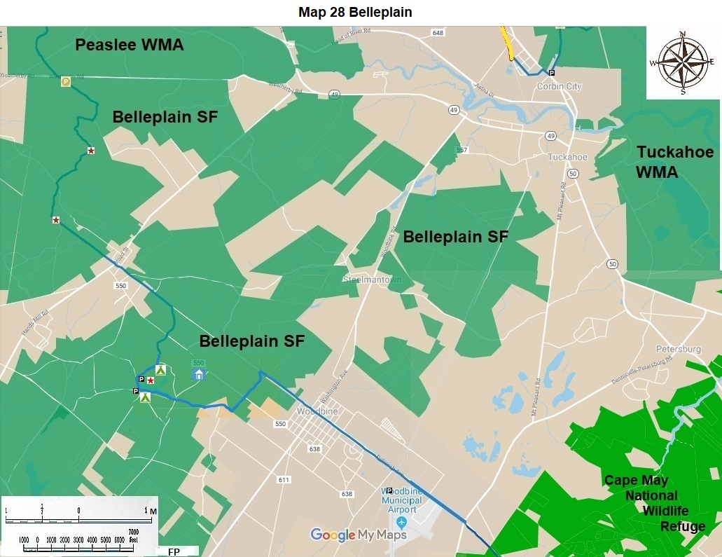
Hike south into Belleplain State Forest in Cape May County. It has nine miles of the Southern Pinelands Trail through upland forests and fields. It is scheduled to be blazed blue in 2020. The names of the trails and their colors are found on the State Forest map, which is on the internet. In 2018 these colors were neither paint blazed nor Carsonite post marked. It is a great place to bird and to observe wildlife and native plants. |
|
0.0 |
Proceed 0.6 miles to the southeast on the “Forest Mapped” blue Old Cape Trail. Turn right or south on an unmarked or named trail for 0.3 miles. Turn right or west on the Forest Mapped orange Kalker’s Pond Trail for 0.7 miles, as it curves back to the east. Observe a small pond. Turn south west on the same trail for 0.8 miles, cross Joe Mason paved road. Continue south west on an unmarked or named dirt road for 0.8 miles. Turn left or southeast on the Forest Mapped yellow Seashore Line Trail. Observe a field on the south. Continue for 1.0 miles to Belleplain Village, a historic Pinelands Village. There is parking here. |
|
6.3 |
This is the premier activity center for Belleplain State Forest. It features boating, swimming, camping, fishing, picnicking, and observing nature. In another 0.1 miles south visit the interpretive center. The next three miles was paint blazed blue in early 2020. Turn left or east on the south side of the lake on Forest Mapped orange Meisle Trail for 0.7 miles. Enjoy the lake. Continue east on paved Kubrik Road for 1.0 miles. Turn left or north on the Forest Mapped pink Boundary Trail for 0.7 miles. Turn right or east on the Seashore Line Trail for 0.4 miles. Park on the paved bicycle trail on Dehirsch Avenue. |
|
|
For the next 24 miles you will be on a planned bicycle trail managed by four municipalities: Woodbine City, Dennis Township, Middle Township and Lower Township. It was funded for much of its length by Cape May County and often placed on property owned by the Atlantic Electric Company. It is sometimes referred to as the Spine of Cape May Trail. |
|
8.7 |
Enter Woodbine City, a large Pinelands town with many amenities. It has a 2.5 mile paved bicycle path running through the City. The bicycle path is flanked by parkland for most of its route along Dehirsch Avenue or CR 550. At 0.5 miles come to Washington Avenue, (CR 557) get off for good food on this main street. In another 1.0 mile come to parking at the Woodbine Airport. In another 1.0 miles leave Woodbine and its bicycle trail for the Cape May National Wildlife Refuge. |
|
11.2 |
The Cape May National Wildlife Refuge is a relatively new Refuge. We hope that its management will cut the NJ State Long Trail through its Great Cedar Swamp Division. The route is that of the old Millville to Cape May City railroad. It is on a raised route through the Great Cedar Swamp. The first 0.8 miles can be observed from the south side of CR 550, Woodbine Ocean View Avenue. Here is the best parking in this division. This is the center of this great marsh. Drainage north is through Cedar Creek to Great Egg Harbor Bay. Drainage south is through Dennis Creek to Delaware Bay. |
|
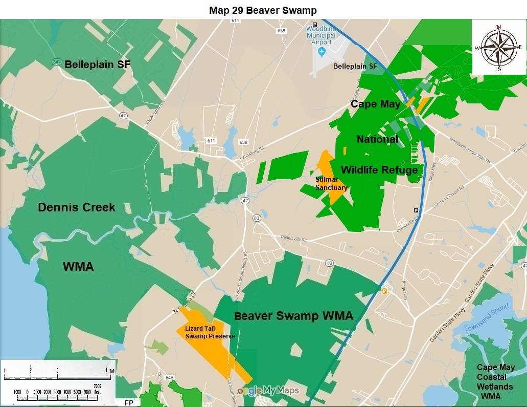
13.2 |
Here there is a good dirt road on private property for 0.1 miles; Dennis Township should buy this property. The dirt road continues as a municipally owned paper street for another 0.5 miles. Near the end of this section, there is a fine pond just to the east of the road. There is an overgrown section of 100 feet between the dirt road and the northernmost part of paved Woodbine Boulevard and a major transmission line owned by Atlantic Electric Company. For now, any hiker should proceed 0.1 mile south on Woodbine Road to near the South Seaville volunteer fire company to parking. |
|
13.8 |
South Seaville is the first nice village on the proposed paved bike way from here to the approach road to the Cape May Lewes Ferry, seventeen miles from here. In 2018 the next five miles is predominantly along the Atlantic Electric power line to Lizard Tail Swamp WMA. The Volunteer Fire Company is near Seaville Avenue and CR 628, Corson Tavern Road. |
|
|
Take the right branch 0.1 miles to Goshen Swainton Road (CR646). Continue south for 0.1 mile to Siegtown Road (CR652). Continue south for 0.3 miles; Lizard Tail Swamp Preserve is on your right. On your left there is a lake, also in the Preserve, for a future side trail. In another 0.1 miles you must bushwhack 0.1 miles west on a temporary bypass route to the existing Lizard Tail Swamp trail system. Follow it 1.0 miles to parking on Dennisville Road (CR657). In the future you will travel on the proposed paved bicycle path to the Cape May Zoo parking lot near CR 657, about 1.0 miles. This action is dependent on Middle Township acquiring a portion of some properties and on construction. |
|
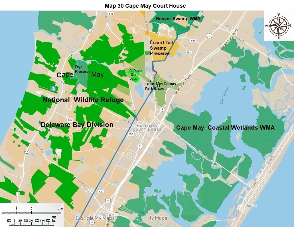
18.9 |
The Cape May Zoo is a great place to visit. Use its west parking lot off Dennisville Road (CR 657). Get on the paved Southern Pinelands Trail 100 feet west of the parking lot. The turn to the west takes you on a side trail to Clarence Davis Municipal Park in 0.5 miles. The main trail on the paved Middle Township Bicycle Trail goes south west to Hand Avenue in 1.0 miles. From here you can go left to the historic downtown in Cape May Court House with good restaurants and parking. Proceed south west on the bicycle trail for four miles, crossing a number of streets, to Burleigh, on Indian Trail Road (CR 618). |
|
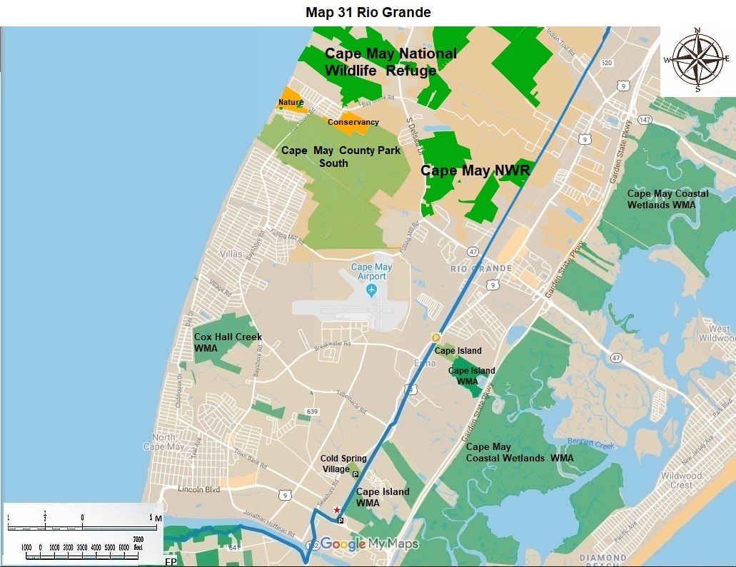
23.9 |
Continue south west on the paved bicycle trail for 3.0 miles to State Highway 47 in Rio Grande. Parking and restaurants can be found nearby. |
|
26.9 |
Continue south west on the bicycle path for 0.3 miles enter Lower Township. Proceed south west on the bicycle path for 1.4 miles to Erma. There is limited parking here on Willow Lane off Seashore Road (CR 626.) Continue south west on the Lower Township Bicycle Trail for 2.0 miles to Cold Spring Village. Visit it. Continue south west for 0.8 miles, passing a nice lake on your right, and coming to a small parking lot on Ferry Approach Road (US 9). |
|
31.4 |
Turn right hike 0.1 miles on the protected bike lane on the highway to the stoplight for US 9 and Seashore Road (CR 626). Use the crosswalks to get to the southwest side. |
|
|
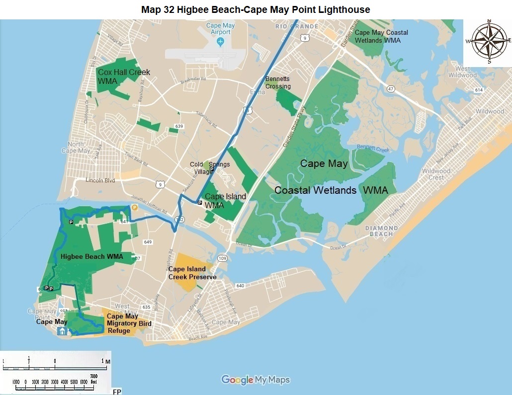
The NJ State Long Trail goes south from this intersection. Proceed 0.5 miles south to the top of the bridge over the Cape May Canal. This is the best view of southern Cape May County that you can get. Hikers and bikers can stop and enjoy it. Motor vehicle users cannot. Continue 0.1 miles south to New England Road. Turn right or west on New England Road (CR 641) for 1.0 miles. Turn Right on Bayshore Road for 0.1 miles to roadside parking at the canal and next to Higbee Beach Wildlife Management Area. |
|
33.2 |
Higbee Beach is a great place to hike, to bird, and to fish. Hike 1.0 miles west on a paint blazed blue trail to the base of the gigantic dredge spoils sight managed by the United States Army Corps of Engineers. Although there are good views from the top, the Army Corps discourages any hiking on this structure. If you go up anyway, please avoid any water or recently wet area to avoid sinking in deeply and getting hopelessly mired. Hike around the base of the structure for 0.2 miles on each of the east, south, and west sides. Hike west along the Cape May Canal for 0.2 miles and south along the Delaware Bay shore for another 0.2 miles. These short stretches are not paint blazed blue for lack of trees, but they are spectacular. Hike them. Turn inland for 0.1 miles. Turn south for 1.5 miles along the well blazed trail through the unusual trees and bushes. There are many side trails through here. Some go over the fabled Cape May dunes. Pass Davy Lake. Come to the Pond Creek area. This area is in line for an extensive renovation for visitors, wild birds, and fish. Enjoy it in the future. The main parking lot at Sunset Beach is on Fish and Wildlife land. This is a great spot for observing sunsets across the Bay and the sunken ship. |
|
36.5 |
The current hike is 0.8 miles east on Sunset Boulevard, past the Martello Observation towers on your right to an unmarked entrance to Cape May Point State Park. In the future we hope that State Parks and Forests and State Fish and Wildlife will cooperate in the following manner. Reroute the trail in Higbee Beach from the main F&W parking lot to the smaller parking lot opposite the Martello Tower and then proceed 0.7 miles east on the southern planned trail south of Pond Creek, then 0.2 miles south through a property to Sunset Boulevard. |
|
38.2 |
The Cape May Lighthouse is the end of the NJ State Long Trail, a journey from High Point to Cape May Point, 383 miles from the High Point Monument. Take a side trip along the Ocean east 1.0 miles to Cape May City for good food, good drinks, and good shopping. |
The Southern Pinelands Trail was designed and mapped by David Mattek, Frank Pearce, and Dick Colby in 2017.
The NJ State Long Trail (NJSLT) is a 383-mile long hiking trail and greenway that will extend from the northern end of the state (High Point, the highest point in New Jersey), to the southern end (Cape May Point, at sea level).
For a printer-friendly version of this page, click here.
< SOUTHERN PINELANDS TRAIL SECTION 1