SOUTHERN PINELANDS TRAIL SECTION - PART ONE
of the NJ STATE LONG TRAIL
Burlington, Atlantic and Cumberland Counties
The Southern Pinelands Trail is roughly 102 miles long. It offers magnificent views of lakes, reservoirs, ponds, rivers, creeks, saltwater and freshwater wetlands and the Cape May Canal, Delaware Bay, and the Atlantic Ocean. Its existing and historic sites include Batona, Pleasant Mills, Amatol, Weymouth Furnace, Mays Landing, Bethlehem Loading Company in Estell Manor County Park, Williamsburg in the Tuckahoe WMA, Cape May Court House, Cold Springs Village, a WW2 “Martello” observation tower, and Cape May Lighthouse. You are on the outer coastal plain, so do not expect much change in elevation, but do expect swampy conditions in and after wet weather, bogs, and plenty of stream crossings. Also be prepared for ticks and chiggers in season, with sealed leggings and chemical repellant.
This description should be read in conjunction with the accompanying map. More of the Southern Pinelands Trail will be paint blazed blue in the near future.
The Southern Pinelands Trail passes through Burlington, Atlantic, Cumberland and Cape May counties.
|
Miles |
Detailed Trail Data from North to South |
|
0.0 |
The Southern Pinelands Trail begins a few miles north of Batsto at the conjunction of the Batsto Lake White Trail and the Batona Trail. Each of the three following loop trails features beautiful views of the lake. In 2017 the white loop trail was blazed white on Carsonite posts for 0.9 miles along the lake. Some of its views are best observed by moving several yards to the right to look down on the lake from the ridge line you are now on. The next loop trail was blazed blue on the posts in 2017. It is at lake level for 0.5 miles of lake views. The third loop trail was blazed red on the posts in 2017. It has 0.2 miles of lake view and 0.2 miles back to the beginning of the three loop trails. |
|
2.0 |
From the park headquarters, go west 0.4 miles through historic Batsto Village. Enjoy the restored residential, commercial and farm buildings, that include an operating sawmill, iron forge, general store, post office, zoo, and craft centers. There are no trail markings here. At the beginning of the woods, posts painted yellow go north on the existing yellow trail, straight into the woods for 0.2 miles, cross the Mullica River Bridge into Atlantic County. Continue northwest for 0.2 miles on the trail marked yellow; continue northeast and northwest for 0.2 miles to view the new (2019) bridge site on your right for the yellow trail back across the Mullica and the deep but empty Pleasant Mills Industrial Canal on your left. Hike 0.1 miles west to the unmarked West Mill Fire Line Road. Hike 0.3 miles south on it to the weakened Nescochague Creek Bridge. This bridge has been closed to vehicular traffic for years. Cross it carefully on its north side. You will now pass the Pleasant Mills Methodist Church. |
|
4.5 |
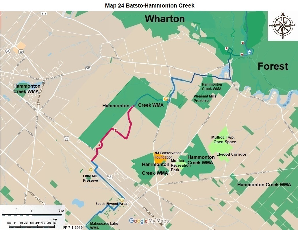
Road Hike. Go straight from the parking lot 0.6 miles on Elwood Pleasant Mills Road (CR 623); turn right or west on Jackson Road for 0.9 miles; continue west on CR 542 for 0.2 miles. Turn left or south on Moore Avenue. It makes a right turn in 0.3 miles; follow it another 0.6 miles. Turn left onto Columbia Road (CR658) for 0.7 miles, pass Hammonton Creek. Just after the guard rail ends there is space for roadside parking. This roadside parking is 0.9 miles south of CR 542. |
|
8.0 |
This is the entrance to Hammonton Creek Wildlife Management Area. There is an unblazed, dead-end hike here of 1.4 miles. The first 0.1 mile follows the open field west then south. Please avoid the residential house, the pen for large dogs and the equipment storage area, to your left. Turn west onto a well-used dirt road, after 0.1 miles pass a creek, after another 0.6 miles find a less used dirt road and turn left or south for 0.6 miles. At the well-marked no trespassing signs, turn around and hike back to Columbia Road. |
|
12.0 |
Proceed south another 0.2 miles on Snow Hill Road cross the active Atlantic City Railroad. Turn left on Railroad Avenue for 1.3 miles. This is a pleasant rural street for hiking, unlike the faster state highways and county roads in this area. Older hikers should describe the board game “Monopoly” to younger hikers. At Spruce Street turn right for 0.2 miles. Pass Reading Avenue, park on Spruce Street, respect the construction company’s, located to your right, need for access. |
|
13.6 |
Hike straight south into the woods up a hill. Yes, a hill. The streets through here are paper streets owned by Mullica Township. Some of the properties are privately owned. A few of those are posted no trespassing. A minority of these properties are owned by the State. Many are owned by the Township. You should stay on the dirt roads. Proceed 0.6 miles south on dirt Spruce Street. Turn right or west on an unmarked street for 0.3 miles. Turn left or south on another unmarked dirt road for 0.6 miles. Come to a place owned by F&W on the left side of this road. Continue straight ahead for 0.6 miles. The left side of the road is paint blazed blue here. Turn left on Blueberry Road for 0.7 miles. At CR 623 (Weymouth-Elwood Road) turn right and hike 0.1 miles to the target practice range. |
|
16.5 |
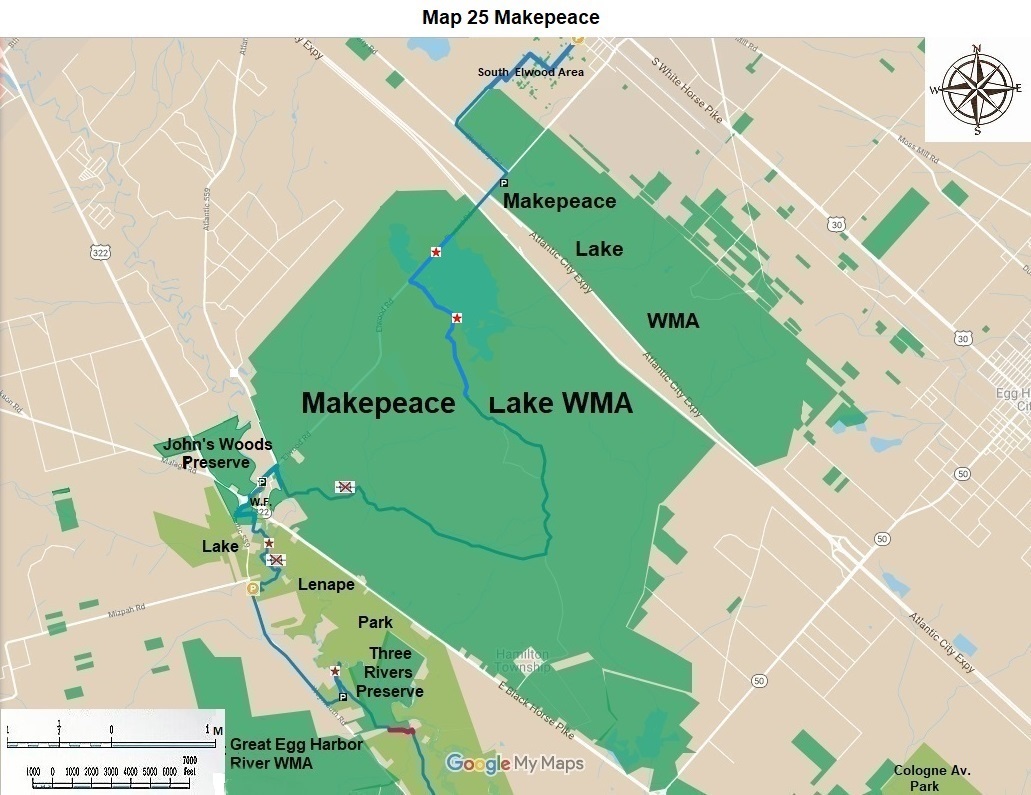
This is the principal parking lot for the 11,624 acre Makepeace Wildlife Management Area. Its principal purpose is a target range. Respect the activities of any users of the range. The whole nine miles of the trail in Makepeace WMA is paint blazed blue. The lot is located on CR 623 two miles south of US 30. |
|
24.4 |
Weymouth Furnace County Park includes the remains of an iron furnace and later paper mill—that operated in the 19th century using water power from a millpond upstream and several millraces, and that included a village for workers and their families (Google 'Weymouth Furnace'). The park is used by many kayakers and canoeists enjoying the river between Penny Pot (upstream) and Lake Lenape (downstream). Note the artesian well. Also notice the parallel dry millraces on both sides of the park. Parking here is on CR 559 0.3 miles north of its intersection with US 322. |
|
24.4 |
In 2018 there is a temporary bypass route here. It runs 0.3 miles down CR 559 to US 322 then on down 559 for 1.0 miles to “Foundation” parking. |
|
26.3 |
Foundation parking is 1.0 miles south west of US 322 on CR 559. The ruins of the foundation can be seen from the road. The next 1.3 miles is on CR 559 to Acagisca County Park. |
|
27.6 |
Hike into Acagisca County Park for 0.2 miles to parking. Continue east for 0.2 miles to the spectacular bluffs view of the Great Egg Harbor River. Enjoy. Repeat hiking backwards for 0.1 miles. Then turn left at a 45-degree turn. In 0.1 mile began hiking through the campgrounds. Continue for 0.3 miles to the driveway to the conference center. Continue another 0.1 miles to the end of the county park. |
|
28.6 |
In 2018 the Three River Preserve, a property owned by the New Jersey Natural Land Trust, was not open to the public. In the future 0.5 miles of the trail should be cut through here. It should be restricted to a width of four feet to prevent any vehicular traffic. There is an in-holding with an easement access here. The trail should cross the easement at right angles; hikers should not walk up or down the easement in either direction. |
|
29.1 |
There is a private property which separates the Preserve from the County Park. It should be purchased. Then turn east for 0.3 mile on another access easement. This easement is partially owned by nine private property owners and the county government and includes the Mare Run Bridge. The Trail should be placed on it whenever access has been assured between Three Rivers Preserve and Lake Lenape County Park. |
|
29.4 |
To the immediate south of the Mare Run Bridge, the trail begins again inside Lake Lenape County Park on dirt roads and paths for 2.8 miles to CR 559 or Weymouth Road in Mays Landing. In 0.8 miles hike through a road gate to prevent vehicles from moving through this area. In another 0.2 miles, bushwhack left to the lake for 160”. Now turn right and enjoy the lake on a path which gets better and better as you hike south. This lake view is a high point of the Southern Pinelands Trail. For the next 1.6 miles keep the lake to your left until you reach the park headquarters. Continue out of the park for 0.3 miles to Weymouth Road (CR 559). This is the vehicular entrance to the park. |
|
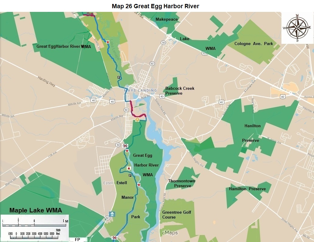
32.2 |
You are now in historic Mays Landing. Turn left on the sidewalk on Weymouth Road (CR 559) for 0.3 miles. We recommend the Cajun food at the town’s main (signaled) intersection, and the nearby bakery and preserved former train station near the trestle that once carried the Newfield Branch of the Reading Railroad across the Great Egg Harbor River. Turn right onto the sidewalk for Mill Street for 0.4 miles, where there is a stoplight at the intersection of US 50 and NJ 40. Turn left after the light for 0.1 miles, pass the gas station, Lenape Plaza, and the MacDonald’s. Turn right on the former route of the Belcoville RR for, this is now private property, but it is open to walkers and bikers, proceed 0.2 to Danehauer Lane. We recommend that Hamilton Township or a Land Trust acquire the route of the rail road for the trail. |
|
34.3 |
The trail is paint blazed blue in this WMA. Hike south for 0.5 miles; turn right for 0.2 miles (This area is wet after a rain.) Turn left or south, hike another 0.5 miles to the missing South River Bridge. This is a great view. You can park here. |
|
35.5 |
The Southern Pinelands Trail runs for 4 miles through Estell Manor County Park. It is paint blazed blue. The Park has more than 20 miles of multipurpose trails and many more miles of mountain bike trails. Some of the multiple natural and historic points are described hereafter. From South River go southeast for 0.1 miles on a bluff or former RR embankment; go south and southwest on Duck Farm Loop for 0.8 miles; make a sharp left on Smokeless Powder Trail for another 0.3 miles. |
|
|
We recommend that the county reconstruct these two missing bridges. This ends your hike on the NJ State Long Trail in the County Park. There is parking here on Purple Heart Drive. This is a plug for a mandatory stop at the nature center at the main entrance to the park. It is 3.7 miles south of Mays Landing on NJ 50. Here you can learn the history of the area from displays, brochures and the staff and get a copy of the park map and its multiple trails left over from the naval ordinance era. |
|
39.5 |
The Tuckahoe Wildlife Management Area is a spectacular place to hike, featuring beautiful views of a freshwater reservoir, salt marshes and pine and oak forests. The eleven miles of the Southern Pinelands Forest through it are paint blazed blue. Parking is 0.6 miles east on Steelman Road from SH 50 4.2 miles south of Mays Landing. |
|
50.7 |
Corbin City is the smallest municipality in Atlantic County. There are good restaurants here in both directions on NJ 50. Cross the highway at the municipal building; proceed northwest for 0.1 miles; turn left on Kansas Road, turn right on Harding Lane, turn left on Samson Road for 0.6 miles of residential street walk. Arrive at the railroad tracks. |
|
55.9 |
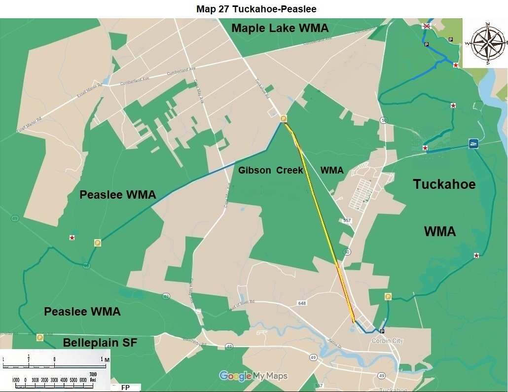
Hike south west for 1.5 miles on paved first Avenue. Peaslee is on your left for most of this jaunt; residential homes are on the right. At Tuckahoe Road (CR 666) First Avenue becomes dirt. Continue south west on it, in 0.7 miles a dirt road coming in from the east on private property may be the future route for this trail. Peaslee is on the right. Continue south west for 2.0 miles. Peaslee is now on both sides of this municipal street. There is parking here. There is also a cool side trail to your right for 0.5 miles to a view of the Tuckahoe River. This side trail will become the permanent route when a proposed Tuckahoe River hiking bridge is constructed. This parking area is 0.5 miles north of NJ 49. |
|
60.1 |
Hike 0.5 miles south on dirt First Avenue; turn right or west on NJ 49 immediately pass an old cranberry operation on the right at the Tuckahoe River and cross into Cumberland County. Continue west on the highway for 0.7 miles to a place with dirt roads on both sides of the highway. To the right there is a side trail for 0.5 mile to the missing Tuckahoe River Bridge. This trail is badly overgrown and should be cut by Cumberland County hikers. To remain on the Southern Pinelands Trail, which is paint blazed blue from here to its end, turn left into the Peaslee WMA woods; go 0.1 miles. Turn left on another dirt road and proceed for 0.7 miles. Turn south west on another dirt road which was heavily overgrown in 2019, for 0.2 miles. Stop at the utility line. The utility line running northwest is the possible beginning of a North Cumberland Trail running from here to south Milmay through Peaslee WMA. Continue south on the same dirt road for 0.8 miles, going around a few curves, to Hunters Mill Road. |
|
63.1 |
Hike south into Belleplain State Forest in Cape May County. |
The NJ State Long Trail (NJSLT) is a 383-mile long hiking trail and greenway that will extend from the northern end of the state (High Point, the highest point in New Jersey), to the southern end (Cape May Point, at sea level).
For a printer-friendly version of this page, click here.