CEDAR CREEK TRAIL SECTION
of the NJ STATE LONG TRAIL
The Cedar Creek Trail is 26 miles long. It travels through pine-oak forests on dirt roads and has good views of several creeks and other bodies of water. Some of the best views are in Double Trouble State Park. This description should be read with the accompanying map. The Cedar Creek Trail is being paint blazed blue.
The southern 14 miles of the Cedar Creek Trail are part of the 383-mile long NJ State Long Trail.
Double Trouble Village to West Canoe Launching parking lot. It is now 5.1 miles long and wholly in Double Trouble State Park.
|
Miles |
Detailed Trail Data from North to south |
|
0.0 |
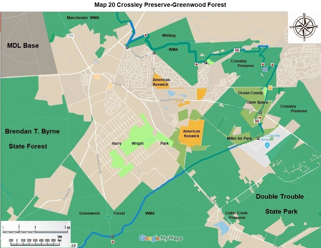
Begin at Double Trouble Village, a great historic site well worth exploring on its own. The village is located at the intersection of Pinewald Keswick Road, CR 618 and Double Trouble Road, CR 619. There is parking for twenty cars here. |
|
0.5 |
Continue west along the reservoir for 0.5 miles; continue west for 0.3 miles, pass behind the Berkeley Municipal buildings, go over some dirt piles disturbed by recreational vehicles, turn north on the power line for 0.2 miles to the intersection with east canoe launch dirt road. |
|
1.5 |
Turn left for 0.2 miles to an obscure right turn. If you go straight on a side trail for 0.4 miles you will get a good view of Cedar Creek. To stay on the trail, go right for 0.2 miles to paved Pinewald Keswick Road, CR 618; turn left or West, go 0.4 miles. |
|
2.3 |
Turn left on a dirt road, go 0.5 miles, veer right go another 1.7 miles, you are now 100 feet south of paved Dover Road with parking. You are on Dover Forge dirt road, which runs south for several blocks through the old forge property with unique vegetation. |
|
4.5 |
To remain on the main hiking trail turn right or west after 0.2 miles and proceed 0.4 miles along field edges and an old fire cut to the west canoe launch site on the creek. This parking area is 0.2 miles south of paved Dover Road, CR 618 and has parking for 10 cars. The trail used to proceed another two miles through the State Park and the County airport; but the county requested that it be rerouted away from the airport. |
|
5.1 |
From parking go 0.2 miles northwest to CR 618. Continue northwest for 1.5 miles to CR 530. This is a good dirt road still in Double Trouble State Park. Continue north and west through Crossley Preserve and county property for 0.8 miles on a good dirt road to dirt Mule Road. |
|
7.6 |
From here go west through Crossley Preserve for 0.6 miles on a badly overgrown fire cut. Then travel north through an unmarked disturbed area of sand for 0.6 miles to the utility line. If you attempt to hike this in reverse, you will be unable to find the disturbed fire cut. At the utility line, hike west for 1.0 miles to Crossley dirt road. There is a pleasant pond to your left before you get to the turn. |
|
9.8 |
The next 2.4 miles of the Cedar Creek Trail is co aligned with the Northern Pinelands Trail. See the Northern Pinelands Trail description on this website from mile 34.1 to 36.5 miles. Stop at the county fairgrounds for lunch. |
|
12.2 |
This is the end of the joint route for the Northern Pinelands Trail and the Cedar Creek Trail. |
The next three sections of this description are part of the NJ State Long Trail. Therefore, we are beginning the mileage count from here at zero.
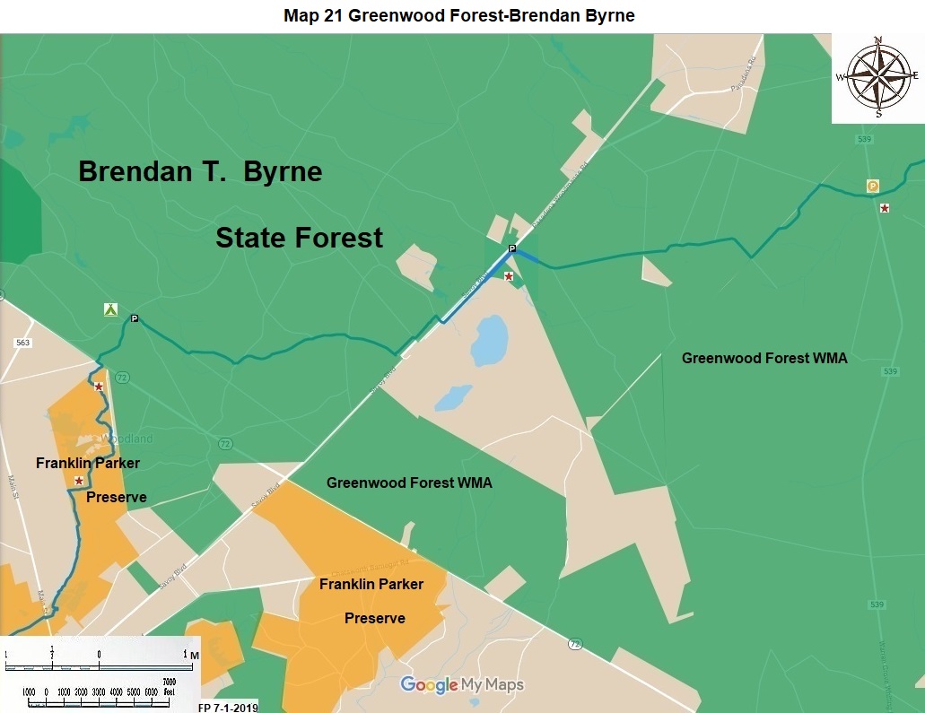
Mule Road to Webs Mill, 4.6 miles. This section is in Greenwood Forest Wildlife Management Area. It is paint blazed blue.
|
0.0 |
This section of trail begins at the northern portion of Greenwood Forest Wildlife Management Area on Mule Road. There is parking for twenty cars at the end of the paved portion of Mule Road one mile south of Pinewald Keswick Road, CR 530. The Northern Pinelands Trail runs north from here. The Cedar Creek Trail continues south from here. Hike south west 1.4 miles to paved Lacy Road, CR 614. |
|
1.4 |
Hike south west from Lacey Road for 2.8 miles, crossing several intersecting dirt roads, and veering left in the last mile. Turn right or west at an intersection 0.4 miles east of CR 539. |
|
4.6 |
There is road parking for twenty cars on CR 539. Webs Mills parking is about five miles south of NJ 70 0n CR 539. It is about 0.3 miles north of mileage marker 20. |
Webs Mill to Bullock, 4.2 miles. This section is in Greenwood Forest Wildlife Management Area. It is paint blazed blue.
|
4.6 |
From CR 539, go west for 0.6 miles; at a four way intersection turn left; continue for 0.3 miles, come to a field, bypass it on the left for 0.3 miles; proceed 0.4 miles to a three way intersection |
|
6.2 |
Turn right, go 2.1 miles; at a y intersection turn right travel 0.5 miles. There is a fine grass strip 100 yards wide for this 2.6 mile hike. |
|
8.8 |
This is Bullock. It has parking for twenty cars. It is at the intersection of Egg Harbor Road in Burlington County and Pasadena Road in Ocean County. Pasadena Road becomes Savoy Road in Burlington County. This site is 3.3 miles north of NJ 72 on Savoy Road. |
Bullock to Batona Trail, 5.4 miles. This section is primarily in Brendan Byrne State Forest.
|
8.8 |
From Bullock go 0.2 miles southeast on the dirt railroad repair road. Turn left for 0.5 miles to walk around an old cranberry bog for a pleasant side trip. Have lunch here. |
|
10.0 |
Turn right cross RR tracks and Savoy Road enter Brendon Byrne. Proceed 0.1 mile on paved Egg Harbor Road; turn left on a fire cut, go 0.6 miles to another dirt road; turn right travel 1.6 miles to Butler Place dirt road, turn left for 0.1 mile to a right turn. |
|
12.4 |
Hike 1.2 miles to gate near Brendan Byrne campground service area. |
|
13.6 |
There is parking for twenty cars here. This parking lot can be reached by travelling 0.6 miles south on NJ 72 from its intersection with NJ 70 and turning east on a dirt road for 0.6 miles. It is near Pakim Pond and the Park headquarters. |
|
14.2 |
The Cedar Creek trail intersects with the Batona Trail 0.6 miles south of the parking lot in Brendon Byrne State Forest. |
The Cedar Creek Trail was designed and mapped by Joe Trujillo in 1992. Joe led group hikes on it for twenty years until his demise.
The NJ State Long Trail (NJSLT) is a 383-mile long hiking trail and greenway that will extend from the northern end of the state (High Point, the highest point in New Jersey), to the southern end (Cape May Point, at sea level).
For a printer-friendly version of this page, click here.