By Craig Volland, Kansas Chapter Agriculture and Air Quality Chair
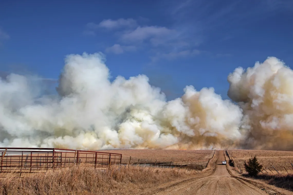
Prairie Fire Smoke | Photo Tom Arnhold, Sierra Club Kansas Chapter
The annual burning of Flint Hills grasslands is almost over. As usual the high winds and rainy days of early spring present a –challenge for ranchers to find days with suitable conditions. So, when such a day presents, they usually jump in to create what I call “big burn days.” This year was no exception. There were 7 such days. Notably, this year’s burn caused far fewer exceedances of the ozone and fine particle (PM2.5) air quality standards (3 this year versus 17 last year) in Kansas or along the border in Oklahoma and Missouri.
Because of last year’s poor result KDHE had convened a meeting of stakeholders, including the Kansas Chapter of the Sierra Club. to revise the Smoke Management Plan. Much of the discussion centered around burn timing and KDHE’s smoke model guidance. The idea is to try to ensure the smoke runs more north and south to stay away from the major metro areas, Wichita, Topeka and Kansas City. But we had noted that the model does not adequately emphasize the times when atmospheric inversions greatly reduce vertical dispersion and hold smoke closer to the ground. That was a major cause of the extremely high levels of smoke that hit Wichita last year. To their credit, KDHE expanded the guidance to ranchers who are supposed to consult the smoke model on KDHE’s website.
This year the heaviest burning occurred from April 6 to 8 and ranchers mostly succeeded in directing the smoke along the north-south alignment of the Flint Hills, as you can see in the smoke maps below for April 7 and 8.
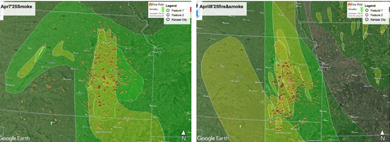
There were no air quality exceedances during that period at KDHE’s few regulatory monitors outside of the Flint Hills. But here’s the fundamental problem. The smoke moving on the north-south alignment still affects a lot of people, including Manhattan, with Kansas State University and Junction City with Fort Riley.
During the April 7 & 8 part of the big burn period, the Chapter’s PM2.5 monitors installed by volunteers from our Flint Hills Group showed that this area suffered 48 hours of smoke in excess of the air quality standard.
In the graphics below, air quality pollution was measured in real time during these two days. The dotted line indicates the average value over the period that exceeds the AQ index of 100, equal to the PM2.5 standard of 35 ug/M3. Another monitor in Junction City came in at 96.5, just under the standard, in a 48-hour period.
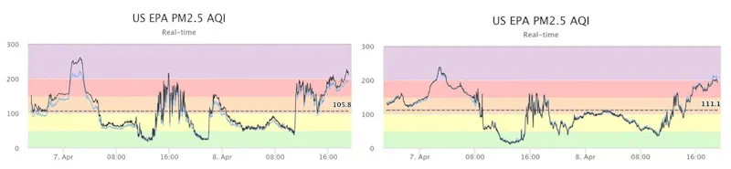
Left to right: Air quality during April 7 and 8, 2025 near the Tuttle Creek Reservoir dam just north of Manhattan, Air quality during April 7 and 8, 2025 in the City of Manhattan
While some progress was made overall in 2025, it was not enough to protect the 100,000 or so people who live within the Flint Hills from Wichita to north of Manhattan. We have already urged KDHE to convince ranchers to avoid burning every year, and to shift some burns from early spring to late summer and fall when they can discourage the spread of certain grass species their cattle don’t like to eat. Based on the results of
our monitoring this year we are also urging KDHE to activate a real time public notification system during big burn days for people and community entities, like public schools, so protective measures can be taken. For example, soccer practice and other outdoor student activities can be postponed. We’ll see what happens as KDHE continues to hear from stakeholders in the review of the Smoke Management Plan.