By Katja Irvin
With the state goal to conserve 30 percent of California’s lands and coastal waters by 2030 (30x30) and increased interest in conservation in the Diablo Range, members of the Sierra Club California/Nevada Wilderness Team took a three-day study trip through part of this vast mountain area which has tremendous potential to contribute to the 30x30 goal. The purpose was to better understand the value of the landscapes in the central Diablo Range, and the potential for greater conservation. Currently, only 28 percent of this landscape has any protection.
I joined Wilderness Team members Anne Henney, JoAnne Clarke, and Vicky Hoover, and Diablo Range enthusiasts (and former Sierra Club staffers) Joan Hamilton and Bruce Hamilton on this inspiring trip around the central portion of the range from Livermore to Coalinga and back along the San Benito and Pajaro Rivers in San Benito County. On Sunday Chance Cutrano, who is involved in large landscape conservation as Director of Programs with the Resource Renewal Institute, joined us.
Day One – Livermore to Mercey Hot Springs / Panoche Valley
Saturday morning, we headed south from Livermore into the San Antonio Valley. Our first stop was near the turn-off to Del Puerto Canyon at the perimeter of the 50,000-acre N3 Ranch, which California State Parks attempted to buy, but was ultimately purchased in 2021 by Bill Brown (founder and board chairman of Walnut Creek wholesaler Central Garden & Pet), who says he is committed to preserving ranch lands. Here we discussed the potential for public ownership or conservation easements for more permanent protection, and we observed the remaining impacts from the extensive and intensive SCU Lightning Complex fires in 2020 and the landscape recovery that has occurred since.
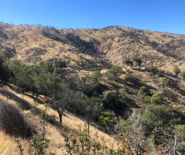
As we entered Del Puerto Canyon, we observed more recovering landscapes interspersed with forests untouched by the fire, which is good news for the continuing habitat value of this landscape. We stopped for lunch and a short hike at the still forested slope above the Frank Raines Regional Park day-use area. It saddened us to see the hillside across the canyon significantly scarred by off-road vehicle usage at the Frank Raines OHV Park.
As we exited Del Puerto Canyon, we noted many interesting rock formations and the proposed location for the new dam that would create the Del Puerto Canyon Reservoir. The Reservoir could submerge 82,000 acres, resulting in significant impacts on habitat for protected species such as California red-legged frogs, California tiger salamanders, and golden eagles. The project would also impact cultural sites and recreation, and cause air pollution and light pollution during construction, among many other environmental impacts.
Then we drove down I-5 to Little Panoche Road where we encountered a totally different landscape at the foot of the Diablo, the San Joaquin Desert ecosystem of the Panoche Valley. Here we were keeping a look-out for several special species endemic to this ecosystem – giant kangaroo rat, San Joaquin kit fox, San Joaquin antelope squirrel, blunt-nosed leopard lizard, and San Joaquin coachwhip.
We spent the night at Mercey Hot Springs, an oasis where many birds thrive in the dense tree canopy. What a wonder to be surprised by the silent swooping silhouette of a great-horned owl at dusk! Later there was an opportunity for a moonlight walk to look for kangaroo rats, hot soaks, and observing the thousands of stars in the dark night sky.
Day Two – Panoche Valley to San Juan Bautista via Los Gatos Creek / Coalinga Road
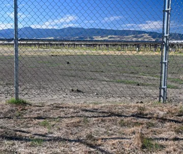
Sunday morning, we drove deeper into the Panoche Valley to view the 1,300-acre Panoche Valley Solar Farm which was the subject of a lawsuit by the Sierra Club, Defenders of Wildlife and Santa Clara Valley Audubon Society. The lawsuit resulted in a settlement agreement to downsize the project from the originally proposed 5,000 acres, and permanently protected 26,000-acres of critical habitat within the Panoche Valley as mitigation. Fences were also designed so kit foxes can crawl under but coyotes cannot, which has been good for the foxes.
Before leaving Panoche we peeked at the beautiful Griswold Hills BLM Management Area which is known to bird enthusiasts for the uncommon species that can be seen. Here we also found an impromptu firing range littered with broken glass and shell casings (BLM rules call for recreational shooters to remove target materials, shells and trash).
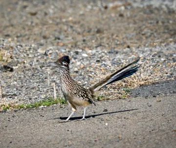
Sadly, we did not see the species we set out to observe in the Panoche Hills and Panoche Valley, but this captivating landscape calls for a return visit to look again. At least we did see some adorable roadrunners!
Next, we headed further down I-5 to Highway 198 in Coalinga and connected to scenic Los Gatos Canyon / Coalinga Road which crosses the Diablo Range through BLM’s Clear Creek Management Area and Laguna Mountain Access Area. We checked out Clear Creek’s two main access points. The first one, Condon Peak, allows OHV access and is a bit trashed by off-roaders, but down the road at Clear Creek itself, Oak Flat is a shaded campground near distinctive serpentine barrens on steep hillsides.
At the top of the pass, we stopped at the Laguna Mountain Campground for a short hike on the beautiful Laguna Falls Trail. We didn’t make it to the falls (3 miles each way) but enjoyed the landscape and the silence…another place that calls for a return visit! Dusk was upon us as we dropped down to the San Benito River Valley and on past the entrance to Pinnacles National Park to Hollister and San Juan Bautista.
Day Three – San Juan Valley, Gabilan Range, and Quien Sabe
Monday morning started at the Old Stage Road trailhead in San Juan Bautista with a hike up through the fog into the Gabilan Range on the 5.3-mile Juan Bautista De Anza Trail, which is known for great views. The Gabilan provides an important connecting wildlife corridor between the Santa Cruz Mountains and the Diablo Range. True to its reputation for good birding, we saw many birds from the trail, including a white-tailed kite and a kestrel perched together atop a tree!
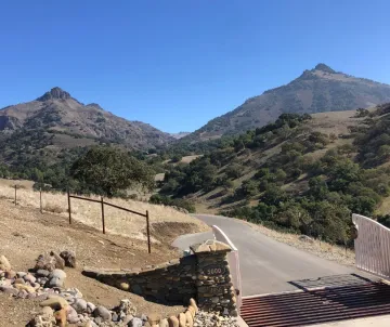
Then we headed east across the valley on funky ag roads to another spot in the Diablo Range with surprising volcanic peaks known as Quién Sabe (from the historic Rancho Quién Sabe Mexican land grant). Although still in private ownership, there are ambitions to conserve this distinctive landscape and habitat.
Our three-day exploration was fruitful and educational. We certainly got more inspired to protect the diverse, rugged, arid, beautiful, and sparsely populated Diablo Range.
Special thanks to Anne for organizing the trip, to Vicky for organizing meals for our cabin at Mercey Hot Springs, to Bruce and Joan for sharing their knowledge of the Diablo Range, and for Bruce, Anne, and JoAnne for driving. What a team effort and an amazing enlightening trip!
More Information About Efforts to Protect the Diablo Range
Joan Hamilton has made a series of videos that cover the places and issues we visited, including ones on the fires, Corral Hollow, Del Puerto Canyon, condors and Pinnacles, and the successful land use fight in San Benito County. You can find them all at her website. Later this year she will have one available on Panoche and the San Joaquin Desert. Enjoy!
Convening: Building a Diablo Range Community, blog by Bruce Hamilton
The Diablo Range: A Mountain Range Hidden in Plain Sight, presentation by Joseph Belli, author of The Diablo Diary, at the Diablo Range convening.