Visualizing Sea Level Rise
What are King Tides? They are predictable high tides that occur annually. King Tides form naturally from the alignment of the sun, moon and earth's gravitational forces.
Sea level rise (SLR) is the sea's surface rising up around the world. This is caused by meltwater from melting ice sheets and glaciers and by warming temperatures which expand water molecules.
The King Tides Project is a visual representation of what SLR may look like for the Bay Area. It helps determine which areas may have the greatest impact from SLR and allows decision makers to be informed with planning and adaptation. See our King Tides Project webinar recording for more information. King Tides will occur: January 2-3, 2026.
Photographing the King Tides
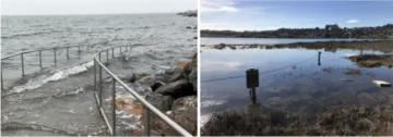
Photos courtesy of the CA Coastal Commission King Tide Project (2019)
- Go to your location of choice (you can use a location on the map or wherever you'd like).
- Take a photo during the highest part of the tide (this is the hour span of time indicated on the map).
- Include in the photo a landmark or object that can help show the scale (ie. sidewalk, bridge, road, etc.).
- If possible, turn on GPS feature on cellphone cameras to record time and location data of the photos.
- If you can, return back to the same location during a normal tide and take the same photo. This will allow for a comparison between the King Tide and a regular tide.
Some things to keep in mind
These photos are telling a story. Landmarks will help make the impacts more visible: floating docks, posts, trails, manholes, etc. Wildlife may act peculiar during King Tides, you may see species you would not normally see!
Learn more about the California King Tides Project
- Visit the California King Tides Project website
- Learn how to participate
- Explore maps of previous Kings Tides