
February 19, 2026
San Mateo City Council
330 West 20th Avenue
San Mateo, CA 94403
Subject: Comments on Integrating Climate Resilience in the City of San Mateo Zoning Code Update
Dear San Mateo City Council,
Thank you for the opportunity to provide comment on San Mateo’s Zoning Code update process. We believe the zoning code update is a crucial opportunity for the City to incorporate forward-looking sea level rise and flood resilience policies into the City’s guiding documents.
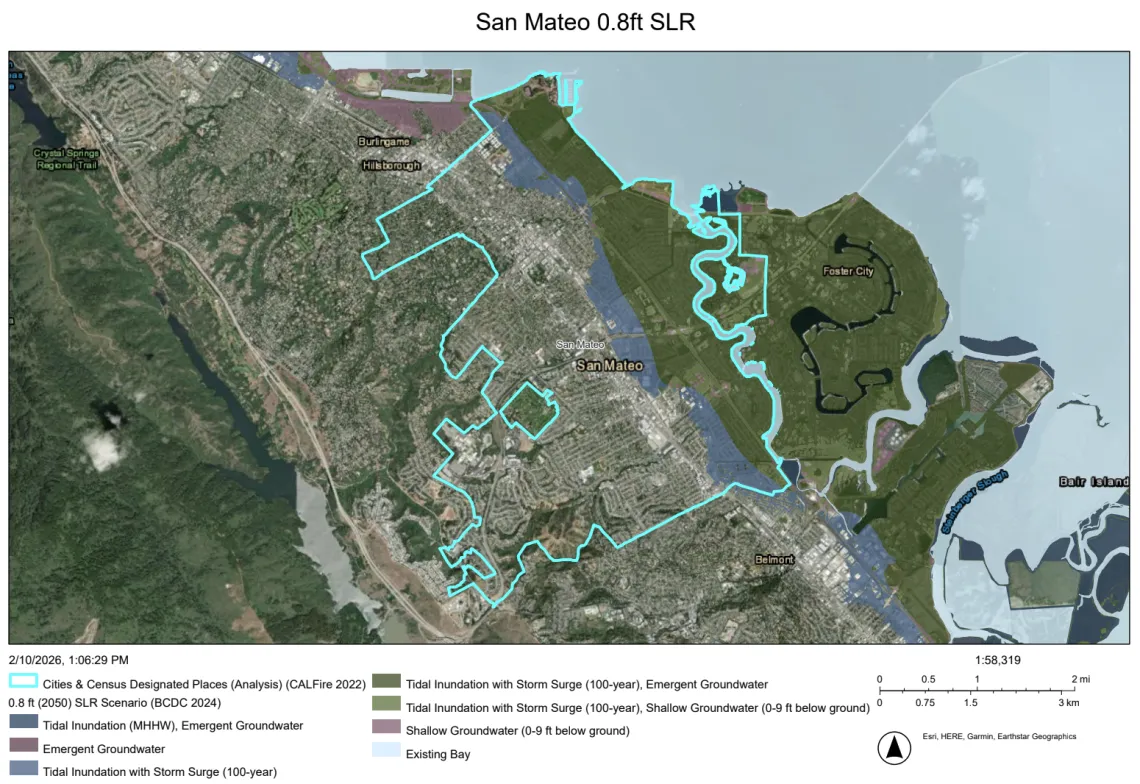
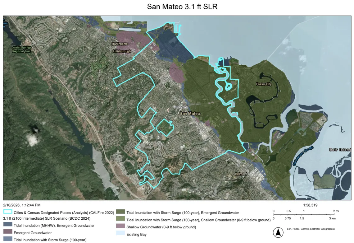
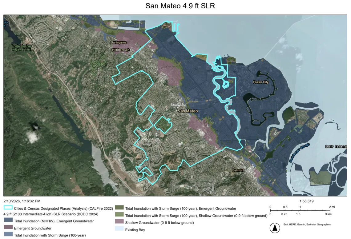
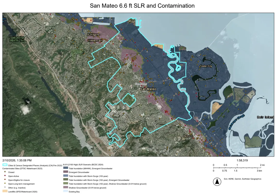
San Mateo has a significant amount of housing, commercial building, essential infrastructure, and roadway in low-lying areas near the shoreline that face increasing risk as sea levels rise and storms intensify. If sea levels rise by 3.3 feet, a conservative estimate for 2100, this would put at risk 12,005 residential parcels, 7 emergency shelter sites, 20 miles of highway, and many other assets.1 Additionally, rising groundwater may inundate contaminated sites near the shoreline, potentially posing a health risk to surrounding Bay ecosystems and community members (see maps attached).
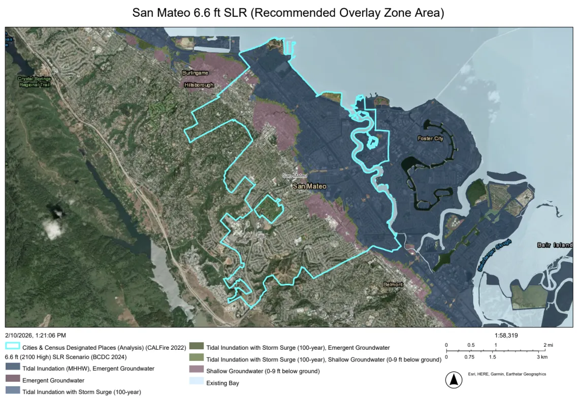
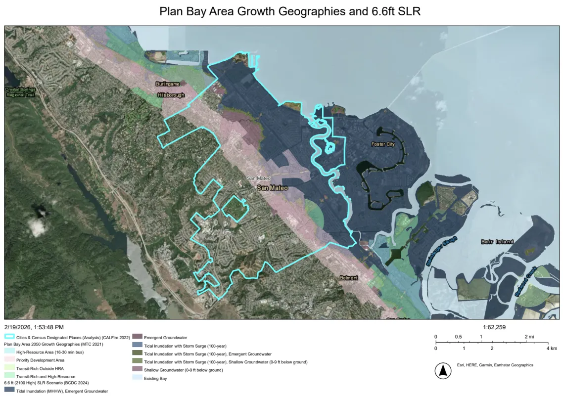
At 6.6 feet of sea level rise, San Mateo will have 1,028 acres of Plan Bay Area 2050 Growth Geographies2 exposed to sea level rise and resulting groundwater rise (see maps attached). This means that more than 50% of the geographic areas where future growth in housing and jobs is likely to happen during the next 30 years will be at risk of flooding3. As these areas develop, it’s critical that new buildings and infrastructure be resilient to climate-driven flood risk.
In order to address this issue, we recommend that the City create a Sea Level Rise and Groundwater Rise Overlay Zone for the area that will be impacted by 6.6 feet of sea level rise and the resulting groundwater rise (see maps attached). This approach is strongly supported by OneShoreline’s 2023 Shoreline Policy Planning Guidance4 and the Bay Conservation and Development Commission (BCDC)’s Regional Shoreline Adaptation Plan (RSAP).5
The RSAP sets standards for how all shoreline communities in the Bay will address sea level rise in subregional shoreline adaptation plans, as required by SB-272. The RSAP lists overlay zones for sea level rise and emergent groundwater as a suggested strategy to meet Adaptation Strategy Standard 5, “Preserve natural and undeveloped lands for shoreline resilience,” Adaptation Strategy Standard 6, “Minimize flood risks in areas with existing and planned development,” and Adaptation Strategy 8, “Promote safe, sustainable, and strategic growth and density.”6 Establishing an overlay zone during this Zoning Code update would allow the City to align land use policy with its forthcoming subregional shoreline adaptation plan and ensure consistency with RSAP requirements.
OneShoreline’s Planning Policy Guidance provides model language for Sea Level Rise and Groundwater Rise overlay zones covering areas subject to the future conditions associated with 100-year flood plus 6.6 feet of sea level rise. Within such an overlay, the Guidance encourages cities to establish design and performance standards requiring new developments to include the following:
Establish a minimum lowest floor elevation of 3 feet above the current base flood elevation,
Incorporate setbacks that place flood infrastructure as landward as feasible, preserving transition space for habitat migration and future levee widening or ecotone slopes7,
Contribute to regional shoreline infrastructure funds OR build/maintain shoreline infrastructure that provides protection to the FEMA + 6 standard, or if lesser, provide land rights/easements to enable the city or OneShoreline to meet that standard,
Evaluate and plan adaptations for future flood conditions for the project lifetime,
Conduct a watershed-level groundwater rise analysis to understand and address impacts such as buoyancy, seepage, infiltration, liquefaction, and corrosion, and plan for management of groundwater rise inboard of flood protection infrastructure, and
If located on or near a contaminated site, consider impacts of rising groundwater on contaminant mobilization and have a monitoring and remediation plan.
There is precedent in San Mateo County to adopt an overlay zone. Burlingame, South San Francisco, and East Palo Alto are examples of nearby San Mateo County cities that have already implemented sea level rise overlay zones.
Additionally, this recommendation aligns with San Mateo’s existing planning documents. The Safety Element, in Section 3.13, commits to “evaluate establishment of a sea level rise and/ or flood overlay zone as a primary mechanism for establishing adaptation policies, rules, or construction codes.” Additionally, Section 3.3 commits to "Ensure that new development, substantial retrofits, critical facilities, City-owned buildings, and existing and future flood control infrastructure are planned and designed to accommodate climate change hazards, including increases in flooding, sea level rise, and rising groundwater, based on the best available science.”
Integrating overlay zones into the Zoning Code Update would operationalize these commitments and provide a durable regulatory framework that protects residents, infrastructure, ecological function, and future adaptation options. We look forward to partnering with the City to ensure that zoning and shoreline adaptation planning proceed in close alignment and position San Mateo for long-term resilience.
Sincerely,
David Lewis
Executive Director
Save The Bay
Jennifer Chang Hetterly
Bay Alive Coordinator
Sierra Club Loma Prieta Chapter
1 “County of San Mateo Sea Level Rise Vulnerability Assessment”, 2018. Pg 157.
2 “Plan Bay Area 2050 Growth Geographies”. 2021. https://planbayarea.org/sites/default/files/documents/PBA2050_Growth_Geographies_Oct2021_0.pdf?cb=01d085e9
3 Bay Conservation and Development Commission, Regional Shoreline Adaptation Plan Atlas https://rsap-atlas.bcdc.ca.gov/
4 OneShoreline Policy Planning Guidance to Protect and Enhance Bay Shoreline Areas of San Mateo County, June 2023, pp. 27-47. https://oneshoreline.org/wp-content/uploads/2023/09/OneShoreline-Planning-Policy-Guidance-Final-June-21-2023-For-Web.pdf
5 Bay Conservation and Development Commission Regional Shoreline Adaptation Plan, December 2024, Adaptation Strategy Standards 2-6, 8, 16, pp. 156-159, 163. https://www.bcdc.ca.gov/wp-content/uploads/sites/354/2024/12/regional-shoreline-adaptation-plan.pdf
6 Ibid. Pg 158-159.
7 This policy also aligns with the RSAP Guidelines. Ibid. Pgs 123, 157, 159, 197.