
September 19, 2025
Redwood City Planning Services
Attention: Margaret Netto, Principal Planner
1017 Middlefield Road
Redwood City, California 94063
Email: mnetto@redwoodcity.org
Subject: Response to the Notice of Preparation for the Draft Environmental Impact Report for the Redwood Life Project
Dear Ms. Netto,
The Loma Prieta Chapter of the Sierra Club, the San Mateo County Bird Alliance, and Green Foothills respectfully submit the following scoping comments in response to the Notice of Preparation (NOP) for the Draft Environmental Impact Report (DEIR) for the Redwood Life Project.
Our organizations have a deep interest in the San Francisco Bay, its ecosystems, and the surrounding shoreline communities where development decisions have long-term consequences for public health, resilience, and environmental justice. We have participated in community meetings, engaged with local residents, with city staff and consultants, and commented before the Planning Commission and City Council throughout this planning process.
At more than twice the size of the Oracle campus built in 1989, the Redwood Life Project would be the largest development in Redwood City’s modern history. Unlike past projects, however, it is proposed on a closed, degrading1 landfill surrounded by sensitive shoreline habitats and residential neighborhoods, and subject to accelerating risks related to sea level and groundwater rise. This creates unusually precarious site conditions for new development. The combination of unprecedented scale and uniquely vulnerable conditions raises extraordinary risks of long-term harm to people, the Bay ecosystem, and regional resilience.
For these reasons, we urge the City to pursue a broad scope and rigorous analysis for the DEIR, evaluate the project’s long term impacts related to sea level rise using the projection criteria required by the Bay Conservation and Development Commission’s Regional Shoreline Adaptation Plan, and provide vigorous and enforceable mitigations beyond the minimum required by CEQA. If the City fails to fully evaluate and address these risks, the consequences could be irreversible.
The Redwood Life Project will profoundly shape the future of Redwood City’s shoreline and the resilience of the Bay Area as a whole. We appreciate the opportunity to provide comments to ensure the DEIR reflects the full scope and gravity of the project’s potential impacts.
1. Project Description: Accuracy and Completeness
Under CEQA Guidelines §15124, a project description must include sufficient detail about a project’s location, objectives, and physical characteristics to provide an accurate, stable, and finite description of the whole of the action, sufficient to enable informed public comment at the scoping stage. If the project’s scale, major elements, or setting are understated or incomplete in the NOP, the public cannot reasonably identify the full range of concerns and potential impacts for the City to study. This undermines CEQA’s goal of informed public participation at the scoping stage and risks leaving major issues under-examined in the DEIR.
This NOP fails to provide a clear and complete summary description of the Project and site conditions, leaving the public unable to grasp its true scope or potential impacts and comment accordingly. Mere inclusion of a link to the lengthy and complex planning application is insufficient disclosure for a lay audience.
Actions Requested
Please address the following omissions and/or inconsistencies in a revised Project Description Summary and re-issue the NOP for an additional comment period.
The NOP makes no mention at all of the landfill or the magnitude of the Plan area’s vulnerability to sea level rise.
The NOP makes no mention of the 25-year timeline for the project or the phasing of construction, leaving the public unable to anticipate the magnitude or duration of construction impacts.
The NOP Project Summary omits key additional project elements of public concern, including more than 1,000 piles through the landfill cap,2 8 to 10 feet of surcharge soil3 (likely unsupportableable by the cap), and an eight-foot raise of Bridge Parkway, all of which must be disclosed in the NOP and analyzed in the DEIR.
Application materials show a project far larger than staff reports and the NOP suggest, revealing a scale over five times that of existing development. According to the Application, total built square footage, including parking structures, will be over 5 million square feet, far greater than the 2.73 square feet commonly used by the City to describe the size of the project. By comparing only the life science buildings to the existing conditions, the NOP could easily mislead the public into believing the project’s total built square footage would be less than two times the current size, rather than the actual five times increase. Additionally, the NOP’s inconsistent reference to square footage, rooms, stories, and heights perpetuates confusion and risks further misunderstanding of the project’s size. This lack of transparency and full disclosure must be corrected. Please revise the NOP project description to include total built square footage, stories, and heights for all major project components.
Additionally, please address the following in the DEIR Project Description.
Provide a full description of the landfill and its history, and detailed description of the landfill’s current status, and any ongoing “post-closure” environmental controls (such as leachate collection, methane venting and monitoring, groundwater monitoring wells, regular inspections and monitoring programs).
Please provide a phasing plan in the DEIR Project Description and discuss the impacts from each phase, and cumulatively, in the analysis and mitigation measures for all relevant CEQA categories.
2. Alternatives
Under CEQA Guidelines §15126.6, an EIR must describe and evaluate a reasonable range of alternatives to the project that would feasibly attain most of the basic objectives while avoiding or reducing significant environmental impacts. A narrow or perfunctory alternatives analysis undermines the informational purpose of CEQA and deprives the public and decisionmakers of meaningful choices.
For a project of this extraordinary scale and in an area with precarious conditions, meaningful alternatives are essential. The NOP and Staff Report do not describe how alternatives will be framed, nor do they indicate whether substantially reduced or reconfigured alternatives will be considered. Minor variations of the proposed project would not be sufficient.
Alternatives should not only evaluate reduced overall intensity, but also account for the project’s unique shoreline setting, landfill conditions, and cumulative regional impacts. Smaller-scale or setback-based alternatives may also shorten the 25-year construction timeline, thereby reducing long-term disturbance to residents and sensitive wildlife.
Actions Requested
Evaluate the potential for a variety of alternative approaches to reduce environmental impacts, including but not limited to those listed below. We refer you to the recent Brisbane Baylands Specific Plan DEIR as an example. In addition to the no-project alternative, the Baylands DEIR analyzed 7 land development alternatives that redistributed or reduced the amount of residential and commercial development, and compared their impacts in a side by side chart along with the Specific Plan impacts.4
Reduced-Intensity / Smaller-Footprint Alternative: Reduce the total square footage. This would reduce traffic, air emissions, construction noise, geotechnical risks, and added exposure of the unlined landfill to sea level rise.
Reduced-Employment Alternative: Explicitly scale back R&D/office square footage to reduce jobs generated and corresponding induced housing demand. This would directly mitigate regional transportation, VMT, air quality, and equity impacts tied to the jobs–housing imbalance (see Section 12, Population and Housing).
Shoreline Setback Alternative: Move buildings inland to minimize shading of wetlands, reduce flood risk, protect wetlands and habitat5, and provide space for future sea level rise levee alignments.
Reduced Building Height Alternative: Lower maximum building heights to lessen shading of wetlands, visual impacts, improve neighborhood compatibility, and reduce seismic/geotechnical risks.
Ensure the DEIR clearly explains why any alternatives are rejected, with supporting evidence of infeasibility, consistent with CEQA Guidelines §15126.6.
3. Cumulative Impacts
CEQA requires cumulative impacts to be evaluated where “the incremental effects of an individual project are considerable when viewed in connection with the effects of past, current, and probable future projects.” The Redwood Life Project’s 25-year phased construction makes cumulative analysis especially critical. What might otherwise be considered temporary impacts, e.g. traffic interruptions and congestion, dust, pile driving noise, and truck trips, become chronic, additive long-term stressors for residents and wildlife when repeated over decades. Combined with other major projects in the Redwood Shores commercial zone near the freeway interchange with Marine Parkway and the two new Innovation Zones in the City of San Carlos, the cumulative impacts of this project could create regional-scale effects.
The DEIR must address how decades of overlapping construction will affect sensitive shoreline ecosystems, strained transportation corridors, and nearby neighborhoods.
Actions Requested
Treat the 25-year phased buildout itself as a cumulative impact driver, not a series of isolated temporary effects. Address how the prolonged development window contributes to cumulative impacts on the following.
Air Quality & GHG Emissions: decades of construction emissions combined with other regional projects.
Biological Resources: chronic disturbance to wetlands and endangered species along Belmont Slough.
Traffic & Transportation: long-term lane closures and detours compounded by flood-prone access roads.
Noise & Vibration: decades of disruption to nearby residents and wildlife.
Public Services & Utilities: overlapping demands on police, fire, water, and stormwater systems.
Community Quality of Life: long-term disruption to housing stability, property values, Bay Trail access, and neighborhood livability.
Evaluate whether a shorter buildout horizon or reduced-scale alternative would lessen cumulative impacts to a less-than-significant level.
4. Aesthetics
The design of large biotech buildings, especially their roofs, presents unique aesthetic challenges that affect both surrounding residential communities and the adjacent slough environment. While biotech labs must meet stringent functional and regulatory requirements, including continuous ventilation and rooftop exhaust systems, these needs must be balanced with protections against visual impacts, glare hazards, and community concerns about perceived pollution sources.
Daytime Glare
Reflective surfaces on building exteriors can create nuisance glare for neighbors and hazardous conditions for drivers, cyclists, and wildlife. To minimize these impacts, the DEIR should establish clear standards limiting the use and placement of reflective materials.
Roof Design and Equipment
Biotech facilities require extensive rooftop equipment, including exhaust fans, ventilation stacks, and high-plume induction systems to safely disperse laboratory emissions. While these systems are critical for safety and regulatory compliance, they can create substantial visual impacts if not properly designed and screened. Tall rooftop stacks are especially problematic, as they are often perceived by the public as “pollution generators,” even when functioning safely. Screening, enclosure, and careful integration are necessary to ensure compatibility with nearby residential neighborhoods and sensitive shoreline habitats.
Actions Requested
Prohibit use of highly reflective exterior materials above specified thresholds, including on roofs and concave surfaces, and establish design standards to minimize glare.
Require stainless steel, polished metals, and similar surfaces to be finished or screened to avoid reflective glare.
Require rooftop equipment, including HVAC systems and exhaust assemblies, to be enclosed in equipment rooms or screened from public view.
Minimize the height and visual prominence of laboratory exhaust stacks to the greatest extent consistent with regulatory safety requirements.
Incorporate aesthetic design guidelines into the DEIR that ensure biotech building roofs and façades are compatible with surrounding residential areas and the adjacent slough environment.
5. Air Quality and Greenhouse Gas Emissions
The project’s location — a shoreline landfill surrounded by residential neighborhoods (including homes, a library, and a park) and a state ecological reserve — makes air quality impacts especially consequential. During a 25-year phased buildout, both construction and operations will generate large volumes of emissions. Construction will involve pile driving, hauling, demolition of existing buildings and landfill gas systems, and road and utilities raising. Operations will include thousands of daily vehicle trips.
The Project also proposes 273,000 square feet of life sciences buildings. Biotech laboratories are uniquely intensive in energy and air quality impacts. Diesel generators can emit substantial particulate matter during routine testing, while fume hoods and HVAC and exhaust systems can release chemical pollutants and odors. Generators must be tested regularly,6 usually weekly, which can create persistent emissions and noise.
In addition, the underlying landfill is itself a source of greenhouse gas emissions. Without rigorous analysis and mitigation, these cumulative emissions will harm both human and ecological receptors.
Combined with the housing shortfall that forces employees into long commutes (see Section 12: Population & Housing), this project will substantially worsen local and regional air pollution and greenhouse gas emissions unless these unique operational and site-specific risks are fully addressed. Enforceable measures will be essential to avoid undermining local and regional climate commitments.
Actions Requested
Construction Emissions and Health Risk
Model emissions from heavy equipment, pile driving, demolition, and worker trips; model cumulative effects of decades-long phased construction.
Conduct a Health Risk Assessment (HRA) for sensitive receptors within 1,000 feet.
Require Tier 4 Final equipment, no-idling policies, grid-based power for construction, and dust control.
Operational Emissions and Mitigation
Model emissions from diesel generators (including routine testing); include cumulative analysis of emissions if multiple generators operate simultaneously; and require evaluation of cleaner backup power alternatives (e.g., battery storage, renewable-powered systems).
Model chemical emissions from biotech HVAC and fume hood systems based on proposal’s specific request for entitlements for labs at biosafety levels BSL-1 and 2 as well as high-containment labs BSL-3; identify hazardous air pollutants and require advanced scrubbers and filters to minimize offsite impacts.
Quantify long-term emissions from increased vehicle trips; integrate with VMT analysis from the Transportation section; and evaluate beneficial reuse of landfill gas.
Cumulative and Climate Impacts
Evaluate cumulative emissions with other nearby projects, including ongoing landfill gas releases.
Quantify greenhouse gases during the 25-year buildout and require enforceable mitigation (renewable energy, electrification, or sequestration/offsets).
Analyze consistency with Redwood City’s Climate Action Plan and specify binding measures to ensure alignment.
6. Biological Resources
The Redwood Life project site lies within one of the Bay’s most ecologically sensitive corridors. Three sides of the property directly adjoin Belmont Slough and the Redwood Shores Ecological Reserve, home to federally and state-listed endangered species such as the Ridgway’s Rail and Salt Marsh Harvest Mouse, as well as seasonal use by the California Least Tern. The slough and surrounding mudflats provide critical foraging and nesting habitat for fish, invertebrates, and birds; eBird records confirm more than 149 species observed here across all seasons.
Because of these unique conditions, even indirect changes, such as lighting, glass design, human activity, or invasive species, can produce significant impacts. CEQA requires the DEIR to identify these risks fully and commit to mitigation measures that avoid or minimize harm, not rely on voluntary or piecemeal actions. Without enforceable standards, the scale of this project risks steadily degrading the ecological health of Belmont Slough and the adjoining Reserve.
Habitat and Biological Resources Assessment (BRA)
Regional databases are insufficient to capture baseline conditions in a site this sensitive and dynamic. Seasonal shifts in species presence, habitat use, and tidal processes require site-specific biological study. Biological Resources Assessments (BRA), conducted by qualified biologists, are essential, especially due to the 25 year phased development proposed, to ensure tiered projects do not proceed without a clear record of baseline habitat conditions and risks. Without this baseline, piecemeal approvals can cumulatively erode habitat integrity without disclosing the full range of impacts.
Sensitive biological resources triggering the need for the baseline BRA include the presence of wetlands or suitable habitat for special-status species, sensitive natural communities, and important movement corridors for wildlife, such as vegetated corridors and shorelines. Assessments should include natural habitats occurring on or adjacent to a project site, including wetlands, mature trees, unused structures that could support species like swallows, special-status bats or other biological resources.
Actions Requested
Establish a baseline BRA for the entire project footprint, not just individual parcels, to document sensitive habitats and species, and establish a Precise Plan BRA standard for environmental review of tiered projects to ensure they cannot proceed without demonstrating avoidance or minimization of biological impacts.
Include the following in the BRA.
Jurisdictional wetland and/or waters delineations confirmed by USACE.
Habitat evaluations for endangered species (e.g., Ridgway’s Rail, Salt Marsh Harvest Mouse) based on habitat availability, not just sightings.
Consultation with USFWS and CDFW for survey protocols.
Integration of local data sources such as eBird and Ridgway rail studies of the Invasive Spartina Project,7 and consultation with conservation managers for lands along the shoreline.
Consideration of the USFWS Tidal Marsh Recovery Plan8 and relevant references of the South Bay Salt Pond Restoration Project.9
Consideration of existing conservation plans that apply to adjoining lands, including the CDFW’s Redwood Shores Ecological Reserve.
Identify both direct and indirect impacts (dust, contaminants, invasive seeds, noise, light, human disturbance) and establish enforceable avoidance measures applicable to the full development potential proposed for the Project.
Wildlife-Safe Building and Lighting Design
The American Bird Conservancy estimates more than one billion birds die annually from building collisions. Risks are highest below 60 feet but extend across the full height of buildings. In addition, certain building features, regardless of height, create especially high collision risk if left untreated. Requirements for bird-safe treatments only on tall façades would miss the most hazardous zones and architectural features.
The introduction of sources of light from buildings and nighttime glare into the habitat of Belmont Slough and its impact on wildlife species should also be evaluated to identify avoidance actions. Artificial nighttime lighting can cause chronic ecological stress, altering foraging, mating, migration, and predation dynamics for birds, bats, insects, and nocturnal ground-dwellers.
Actions Requested
Require bird-safe glazing at all building heights, with priority treatments below 60 feet.
Extend design analysis to hazardous architectural elements including:
Skyways, transparent walkways, and passageways,
Balconies, freestanding walls, protrusions, and corners,
Transparent or highly reflective free-standing structures,
Glass adjacent to greenery (first three floors), and
Reflective façades on any elevation.
Require mitigations to avoid or minimize nighttime light pollution, including shielded, downward-directed fixtures, redirection of light fixtures to avoid habitats, reduced intensity, operational controls, and seasonal adjustments.
Analyze and mitigate cumulative ecological impacts of both reflective surfaces and lighting in the context of this biologically sensitive shoreline.
Human Disturbance and Predation
Large-scale development along sensitive shorelines does not only introduce buildings; it brings thousands of new daily users: employees, hotel guests, food trucks, and recreational visitors. In wetlands like Belmont Slough, this density of human presence produces a wide range of indirect impacts that can be as harmful as direct habitat loss. Research shows that wildlife retreat from trails when humans approach,10 with waterfowl particularly intolerant of disturbance.11 Food waste attracts gulls, rats, and other predators that prey on eggs and young. Dogs, especially off-leash, can destroy nests or flush sensitive species from foraging areas. Events and outdoor amenities add chronic noise and activity to areas that were previously low disturbance.
Additionally, increased human presence and tall structures will increase predation along the shoreline. Analysis must identify and mitigate to minimize predation. For wetland species, those predators include racoons, opossums, skunks, foxes, rats and roaming cats as well as avian predators. Predation is of major concern for the endangered species that live in the shoreline marshes.
Because the Redwood Life site adjoins federally protected habitat in Belmont Slough, the margin for error is extremely small. Allowing these impacts to accumulate without enforceable restrictions would steadily degrade the ecological integrity of Belmont Slough and the adjoining Ecological Reserve.
Actions Requested
Evaluate and mitigate disturbance from new trails, plazas, and shoreline recreation.
Prohibit or strictly control off-leash dog access along shoreline areas, with enforceable management.12
Require strict food waste management and prohibition of outdoor feeding to prevent predator attraction.
Design landscaping and building features to discourage predator perching, concealment, and nesting, including limitations on shoreline tree planting and tall spiking forms near wetlands.
Prohibit or tightly regulate events and amplified outdoor sound near the slough, with seasonal restrictions during nesting periods.
Require monitoring of disturbance impacts on key species, with adaptive management if degradation is observed.
Wetlands Protection and Shoreline Setbacks
The Belmont Slough wetlands adjoining the Redwood Life site are not just habitat; they are legally protected resources under the Clean Water Act, state wildlife laws, and BCDC authority. Because wetlands are uniquely sensitive to disturbance, indirect impacts from construction, landscaping, or shoreline access can be just as harmful as direct fill. Dust, invasive seeds, contaminated runoff, or oil and chemical spills can travel into marshes with even minor mismanagement. Noise, lighting, and pile driving can disrupt endangered species such as the Ridgway’s Rail. Landscape choices can accelerate erosion or introduce invasives.
The DEIR must therefore treat wetlands protection as a core requirement, not an afterthought. Even if equipment or workers never “touch” the marsh, CEQA requires disclosure and mitigation of these foreseeable indirect impacts. In addition, because the project anticipates future flood protection, it must reserve upland setback space for levees or living shoreline approaches. Without this, the project could force Bay fill or floodwall solutions that contradict regional policies, compromise habitat, and add long-term costs.
Actions Requested
Establish a “no-fill” standard for adjoining wetlands, prohibiting physical or inadvertent placement of soils, rocks, wood chips, or other materials.
Prohibit use of wood chips on levees and require dirt piles to be stored well away from the shoreline, covered when not in use.
Require tire washing and invasive-species prevention protocols for all vehicles and equipment.
Prohibit use of blowers near wetlands, which spread seeds, dust, and contaminants and create disruptive noise.
Limit pile driving and night construction near wetlands; require pre-construction Ridgway’s Rail surveys, nesting-season restrictions within 700 feet, and consultation with USFWS throughout.
Clarify how slough wetlands will be protected during the major earth-moving operations to raise the road and levee by 8 feet per the drawings.
Require shoreline landscaping and project layout to reserve upland setbacks for levee/flood protection projects, ensuring adequate landward space to accommodate raising of levees as rising seas may require and avoiding future Bay fill.
Integrate wetlands protections as Precise Plan mitigation measures, enforceable across all project phases.
7. Hazards and Hazardous Materials
The Redwood Life Project site sits atop the former Westport Landfill, a settling, unlined landfill adjacent to Belmont Slough, and is surrounded by residential neighborhoods and sensitive wildlife habitat. Because the landfill’s contamination risks are inseparable from the site’s vulnerability to flooding, groundwater rise, and seismic instability, this section should be read together with Section 8: Hydrology, Geology, and Soils. Together, these issues represent compounding risks that must be analyzed in an integrated manner in the DEIR.
Data Gaps and Monitoring Needs
Although groundwater and soil gas monitoring has occurred since the 1980s, major deficiencies remain. Recent sampling has detected petroleum products, volatile organic compounds (VOCs), and semivolatile compounds above environmental screening levels, including benzene and vinyl chloride. Yet critical contaminants common to landfills, such as PFAS,13 heavy metals, asbestos, and pentachlorophenol, have not been tested in decades, if ever. Soils have not been comprehensively re-evaluated since the current development was built, and shallow soils will be exposed once demolition occurs. These omissions leave regulators, decisionmakers, and the public without an adequate baseline.
Landfill Gas and Vapor Intrusion Risks
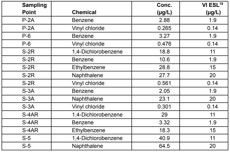
Soil gas contains methane, which poses explosion risks, as well as VOCs, including carcinogens such as benzene and vinyl chloride that create vapor intrusion risks for future buildings. Landfill gas (LFG), which can transport VOCs along with methane to the ground surface, is currently released through passive venting systems, with only four existing buildings receiving active vapor intrusion mitigation.14 A 2018 Ramboll report was “unable to identify regulatory guidance or approval, or a human health risk assessment, associated with sitewide alterations to the sub-grade passive ventilation systems.”15
Sampling from March 2023 found VOC concentrations in six of thirteen “leachate-impacted” groundwater monitoring points above CalEPA vapor intrusion screening levels for commercial/industrial use (see Table 1).16 These exceedances underscore the need for building-specific vapor intrusion assessments before construction. CalEPA’s Vapor Intrusion Workgroup guidance calls for subsurface sampling, risk assessment, and remediation before mitigation design.17 This is a framework the DEIR should follow.
Leachate and Surface Water Risks
Leachate from the landfill contains contaminants harmful to aquatic life; March 2023 monitoring showed naphthalene exceeding California ESLs for saltwater organisms. The collection system, sampled only every five years, is vulnerable to rising groundwater and sea level rise, which may reduce its effectiveness and allow contaminants to migrate into Belmont Slough. Without a robust investigation of seeps and leachate pathways, the DEIR will understate ecological risks.
Cumulative and Long-Term Risks
Construction activities, including grading, pile driving, surcharge placement, and utility trenching, will disrupt the landfill cap and increase contaminant mobility. Planned stormwater infiltration areas conflict with the requirement to maintain an impermeable cap, raising concerns about pollutant leaching. Groundwater rise driven by sea level rise further compounds these risks by increasing pathways for contaminant transport to air, soil, and water. These multiple stressors interact to create long-term exposure risks for humans and wildlife that cannot be ignored.
Actions Requested
Data Collection and Baseline Assessment: Conduct a comprehensive data gaps assessment covering groundwater, soil, and landfill gas; require updated sampling for PFAS, metals, asbestos, and other likely contaminants. Require shallow soil sampling post-demolition and establish acceptance criteria for imported fill.
Human Health and Ecological Risk Assessment: Prepare updated risk assessments using current EPA/DTSC toxicity values for both onsite and offsite receptors. Assess cumulative impacts across all exposure pathways, including inhalation and ingestion of dust, inhalation of VOCs in soil vapor, dust transport to Belmont Slough, and overland runoff after tidal flooding or rainstorms.
Vapor Intrusion and Landfill Gas Controls: Require project-specific soil vapor studies and human health risk assessments prior to construction. Apply CalEPA vapor intrusion guidance to building-specific mitigation designs.
Leachate and Surface Water Protection: Expand monitoring of leachate collection systems and seeps; evaluate impacts of groundwater rise on contaminant migration into Belmont Slough.
Construction and Design Safeguards: Evaluate the potential of construction activities to alter the distribution and transport of pollutants within the landfill and into Belmont Slough. Analyze potential disruption of the landfill cap and/or perimeter cutoff wall and identify how cap integrity will be maintained before, during, and after construction activities such as grading, pile driving, surcharge loading, and utility installation. Ensure stormwater design does not allow infiltration into capped areas. Address the use of pressure-treated lumber in landscaping and evaluate the potential leaching of copper, arsenic, and chromium.
Sea Level Rise and Groundwater Rise: Evaluate how groundwater rise will affect contaminant transport and exposure at full build-out, and require adaptive measures to prevent increased risks to human health and the environment.
Biotech Hazards, BioSafety and Biotechnology Risk
Biotechnology risk is a form of existential risk from biological sources, such as genetically engineered biological agents. The release of such high-consequence pathogens could be
deliberate (in the form of bioterrorism or biological weapons)
accidental, due to human or mechanical error
a naturally occurring event such as flooding or a seismic event
The U.S. government is concerned about the national security and biosecurity risks posed by biotech labs, including the potential misuse of research, foreign competition and acquisition of data, and insufficient oversight.19
Biotechnology laboratories, particularly biosafety level (BSL) 3 facilities, can present significant risks. These include the potential for an accidental highly infectious pathogen release via air, water, or solid waste pathways if containment systems fail. Flooding or seismic hazards could compromise negative-pressure systems, HEPA filtration, or effluent decontamination equipment, allowing uncontrolled releases.
The EIR should fully analyze the environmental impacts of a 100% research and development (R&D) biotechnology laboratory campus for biosafety levels 1,2 and 3, located within a predominantly residential neighborhood and directly adjacent to an ecologically sensitive wildlife reserve. While a single, small BSL-3 laboratory may be relatively contained, allowing multiple BSL-3 facilities across a large campus significantly compounds risk, with potential impacts increasing exponentially.
The EIR must evaluate the worst-case scenario of simultaneous incidents.This evaluation should also address:
Emergency preparedness and containment protocols, including coordination with local Emergency Response agencies.
The proximity to vulnerable populations, including nearby residents, public library, and recreational users of the adjacent ecological reserve.
Potential impacts on sensitive wildlife species from accidental releases or contamination.
The cumulative impact of permitting multiple BSL-3 facilities,20 including long-term oversight, inspection, and enforcement requirements.
For additional Information, see White Paper on Biotechnology Risks and Biosafety by Sierra Club Loma Prieta, Sustainable Land Use Committee
8. Hydrology, Geology, and Soils
The Redwood Life site sits on a closed landfill atop Bay mud, at the front line of the climate challenge where surface water, shallow groundwater, sea level rise, and landfill stability all converge. This area already experiences tidal backflow through storm drains, localized flooding during major storms, and subsidence of the landfill itself. As sea levels rise, groundwater will rise too, saturating soils and threatening both building stability and containment of buried waste. Adding millions of square feet of new, heavy structures and fill on this fragile foundation magnifies the risks of flooding, settlement, liquefaction, and contaminant migration.
These physical vulnerabilities are inseparable from the hazardous materials embedded in the landfill. If groundwater rises or piles fracture the cap, the effect is not only geotechnical failure but also the mobilization of toxic leachate and landfill gas. For this reason, the DEIR must analyze hydrology and geology in direct connection with hazards (see Section 7: Hazards and Hazardous Materials) rather than treating them as isolated risks.
Additionally, in 2024, the Bay Conservation and Development Commission adopted the Regional Shoreline Adaptation Plan (RSAP) Guidelines21, which establish mandatory adaptation strategy standards for local sea level rise planning under SB 272. These standards explicitly require evaluation of both sea level rise (above ground) and groundwater rise (below ground), recognizing that the two processes interact and must be addressed together.22 Similarly, in 2023, the San Mateo County Flood and Sea Level Rise Resiliency District (aka OneShoreline) published Planning Policy Guidance23 for shoreline jurisdictions in San Mateo County to use in setting standards for sea level rise adaptation. In addition to ample content responding to sea level rise itself, the Guidelines document addresses shallow groundwater considerations. Given that the Project’s borders include a substantial length of Belmont Slough, a Report released by the Santa Clara Valley Water District this year24 may be particularly relevant.25
Consistent with RSAP and the OneShoreline Planning Guidance, the DEIR’s regulatory discussion and impact analysis for Hydrology, Water Quality, and Geology and Soils must apply these adaptation standards and planning guidance to ensure project design and mitigations are aligned with current regional requirements and best practice.
Actions Requested
Baseline Data Collection: Conduct systematic shallow groundwater mapping across the site (grid-based borings) and core analysis to establish soil layers and surface to water depth. Establish sitewide monitoring baselines for adaptive management. Use Lidar or equivalent elevation mapping to establish subsidence baselines, with parcel-level monitoring before approvals.
Geotechnical Risks: Incorporate groundwater depth into liquefaction modeling, consistent with regional requirements. Evaluate shoreline slope instability, as identified in the Geotechnical Sensitivity Analysis (“high potential for seismic slope deformation within 200–250 feet of the shoreline”).26
Pile Driving and Cap Integrity: Evaluate whether piles penetrating landfill waste could mobilize contaminants or create leachate pathways; require safe setbacks and post-construction monitoring. Assess whether surcharge fill and new structures will require full reconstruction of the landfill cap. Prohibit infiltration-based stormwater designs that compromise cap impermeability.
Flooding and Sea Level Rise: Incorporate local records of street flooding, tidal backflow, and saturated soils into flood risk modeling. Evaluate whether elevated groundwater reduces stormwater drainage capacity. Analyze long-term risks under mid- and late-century RSAP scenarios, including shallow groundwater.27
Regional Adaptation Coordination: Integrate RSAP Guidelines (2024) and OneShoreline Planning Guidance, and disclose how project-specific flood protection (e.g., Bridge Parkway elevation, levees, or floodwalls) aligns with — and does not preclude — regional shoreline adaptation strategies.
9. Land Use, Shoreline Planning, and RSAP Consistency
The Redwood Life Project site is located directly along Belmont Slough and within the 100-foot shoreline band regulated by the San Francisco Bay Conservation and Development Commission (BCDC). The site is also subject to regional shoreline resilience standards established under the Regional Shoreline Adaptation Plan (RSAP) and the Bay Plan. These frameworks establish key requirements for shoreline development:
Prioritizing ecosystem protection and equity in sea level rise (SLR) adaptation,
Preventing mobilization of contaminants from shoreline legacy landfills under SLR and groundwater rise,
Reserving upland space for levees and nature-based adaptation strategies, and
Protecting public access and recreation along the Bay shoreline.
The Redwood Life site is uniquely constrained; it is a closed landfill subject to subsidence, groundwater rise, and seismic instability (see Hydrology/Geology), and contains documented hazardous materials and leachate pathways (see Hazards). Any long-term development plan must demonstrate consistency with BCDC and RSAP requirements while ensuring that SLR adaptation does not increase risks to neighboring communities, public health, or sensitive ecological resources.
Actions Requested
BCDC Jurisdiction and Bay Plan Consistency
Clearly identify all portions of the project site within BCDC’s 100-foot shoreline band.
Analyze project consistency with the Bay Plan policies on public access, wetlands protection, pollutant discharge, and shoreline resilience.
Evaluate whether proposed stormwater features (e.g., bioretention swales, infiltration) are compatible with landfill containment and Bay Plan requirements.
Regional Shoreline Adaptation Plan (RSAP) Compliance
Demonstrate how the project will incorporate nature-based adaptation solutions and provide adequate setbacks to protect and enhance shoreline ecosystems.
Address the RSAP requirement to evaluate shallow groundwater rise as an adaptation condition.
Show how the project provides upland space for future levee expansion, consistent with regional shoreline protection planning (e.g., SAFER Bay/OneShoreline).
Sea Level Rise and Long-Term Planning
Analyze scenarios where landfill areas are located below sea level by mid- to late-century,28 and disclose how landfill containment and Bay access will be managed under these conditions.
Identify whether the site plan leaves sufficient landward room for nature-based levees or multi-benefit flood protection strategies, avoiding reliance on floodwalls that preclude ecological adaptation.
Require tiered project approvals to demonstrate consistency with updated RSAP guidance over the 25-year buildout.
Public Access and Recreation
Evaluate whether shoreline trails, plazas, and POPA (privately-owned publicly accessible) spaces will remain usable and safe under projected SLR and flooding.
Identify design and maintenance measures needed to ensure continuous Bay Trail connectivity without compromising habitat.
10. Noise and Vibration
The Redwood Life Project poses extraordinary noise and vibration challenges due to its unprecedented scale, sensitive shoreline setting, and 25-year phased construction. Demolition, pile driving, surcharge placement, and heavy truck traffic will generate sustained disruption adjacent to residential neighborhoods, a public library, and the Belmont Slough ecological reserve. In saturated Bay Mud and landfill soils, low-frequency vibration travels farther, compounding risks for both structures and wildlife.
These effects are not “temporary.” With construction phases stretching over decades, noise and vibration will become chronic stressors, undermining neighborhood quality of life and degrading ecological conditions. Operational noise from biotech facilities, including continuous HVAC, exhaust systems, and emergency generator testing, will add to these pressures unless rigorously controlled.
Actions Requested
Construction Noise and Vibration
Model noise and vibration levels from pile driving, surcharge placement, demolition, and heavy truck traffic.
Evaluate cumulative impacts from overlapping construction phases across the 25-year buildout.
Require quieter alternatives to impact pile driving where feasible, restricted hours, noise barriers, and real-time monitoring.
Address vibration risks for nearby residences, the public library, and sensitive laboratory equipment.
Adopt a Construction Noise Management Plan with performance standards, monitoring, an on-site community complaint and response process and enforcement.
Operational Noise
Analyse delivery vehicles serving the biotech labs, as labs are very dependent on multiple special deliveries. Constrain delivery hours as passage is through residential areas.
Model long-term noise from HVAC systems, exhaust fans, fume hoods, and emergency generators.
Evaluate 24/7 operational impacts on residences, open space, and wildlife habitat.
Require acoustic screening, low-noise equipment, and enforceable property-line noise limits.
Establish an ongoing complaint and response program to address community concerns.
Ecological Impacts (Cross-Reference to Biological Resources)
Evaluate species-specific sensitivity to construction and operational noise, especially Ridgway’s rail and other endangered species.
Apply seasonal restrictions and adaptive measures to protect nesting and foraging habitat.
Cumulative Effects
Treat noise and vibration over the full 25-year phased construction as long-term, not temporary, impacts.
Evaluate cumulative quality-of-life impacts from intermittent construction noise plus continuous operational sources.
11. Parks, Open Space, and Recreation
The Redwood Life Project proposes 42.4 acres of open space, including public plazas, parks, walking trails, and Bay Trail additions and improvements. While no residential units are included, the project would introduce thousands of daily workers, a 104-room hotel, and a community amenity center. This new intensity of use will place additional pressure on both onsite and surrounding parks and trails. Because the site is immediately adjacent to sensitive wetlands and habitat areas, the design, placement, and management of these amenities will be especially consequential.
Redwood City’s General Plan establishes a standard of 3 acres of parkland per 1,000 residents. Although the project does not include housing, the influx of workers and visitors will create substantial new recreational demand that should be evaluated against this standard to determine whether community-serving park capacity is adequate.
Most of the proposed open space (38.7 acres) would be privately owned but publicly accessible (POPA). The DEIR must address the long-term enforceability of POPA lands as public amenities, including requirements for clear signage, visibility, and legal access covenants to ensure the community understands and can rely on these spaces as part of the public park and trail network.
Actions Requested
Evaluate how new onsite open space and trails will affect sensitive shoreline habitats, including risks of overuse, disturbance, or invasive species spread.
Assess demand created by project-generated workers, hotel guests, and visitors, benchmarked against Redwood City’s 3 acres/1,000 residents standard.
Require mitigation measures for trail siting and design, including buffers, setbacks, and habitat-compatible materials.
Develop enforceable measures for POPA open space, including signage, public access covenants, and monitoring, to ensure long-term usability for the community.
Provide management and maintenance standards to minimize ecological impacts and guarantee public benefit.
12. Population and Housing
The Redwood Life Project would generate an estimated 9,000 to 10,000 new jobs but provides no on-site housing and only an $80 million housing contribution, likely funding only 120 to 160 affordable units.29 In contrast, housing demand induced by the project is estimated at 4,700 to 6,200 units. This disconnect represents a significant shortfall of more than 95% of demand.
Redwood City already has a jobs–housing imbalance with 2.35 jobs per housing unit in 2019,30 well above the 1.0 to 1.5 ratio considered balanced.31 Adding thousands more jobs without housing will intensify regional inequities, congestion, and air pollution. Workers forced to find housing in other jurisdictions will face long commutes, driving up vehicle miles traveled (VMT), greenhouse gas emissions, and traffic impacts on regional corridors and cause rent increases and displacement within the Redwood Shores community and beyond.
CEQA requires these indirect but foreseeable effects to be disclosed and mitigated. Without an accurate accounting of induced housing demand and where that demand will be met, the DEIR will understate both local and regional impacts on transportation, air quality, and community stability.
Actions Requested
Quantify job growth by land use type and project phase, and translate this into housing demand using defensible ratios.
Evaluate the “fit” between jobs created by the project (by wage band or income level) and the availability of nearby housing affordable to those workers. Use this analysis to inform a housing displacement study that identifies whether unmet demand would intensify competition for existing units, raise rents, and displace lower-income residents locally or regionally.
Specify the number of housing units needed to serve the project-generated workforce and compare this to the units actually deliverable through the $80M contribution.
Identify the jurisdictions expected to absorb the unmet housing demand, so that commute-related traffic, VMT, and air quality impacts can be accurately modeled.
Evaluate mitigation options, such as stronger housing linkage fees, off-site unit production, or project alternatives with smaller employment footprints.
Provide a transparent rationale, supported by evidence, if the City and applicant are not assuming responsibility for the project’s induced housing demand.
Cross-reference to Section 2: Alternatives, ensuring the DEIR considers a Reduced-Employment Alternative that directly addresses the jobs-housing imbalance by scaling back R&D/office square footage.
13. Transportation and Construction Management
The Redwood Life Project proposes more than 5 million square feet of new structures including 3 million square feet of office/lab development and an estimated 9,000 to 10,000 employees. The site is located in Redwood Shores, which has only two arterial access roads (Marine Parkway and Holly Street/Bridge Parkway) connecting to Highway 101. These corridors already experience congestion and are flood-prone during storms and king tides. During a 25-year phased buildout, the project will generate substantial increases in vehicle trips and prolonged construction-related traffic, raising concerns about both circulation capacity and emergency access.
Redwood City’s General Plan Mobility Element emphasizes reducing automobile dependence, while the CAP 2030 sets a target of reducing vehicle miles traveled (VMT) per capita by 30% by 2030. At the regional level, Plan Bay Area 2050 prioritizes job growth in transit-rich areas rather than automobile-dependent locations like Redwood Shores. With a proposed parking ratio of roughly two spaces for every three employees, and applicant-proposed valet parking, the project risks locking in car dependence in direct conflict with these policies.
The project’s phased construction also creates compounding transportation challenges. Transportation Demand Management (TDM) measures will not become effective until a critical workforce mass is reached, leaving early phases especially dependent on cars. At the same time, long-term staging, haul routes, and lane closures will repeatedly constrain limited access roads, creating overlapping impacts on residents, commuters, and emergency responders. Nearby jurisdictions such as Belmont will also bear significant traffic burdens, particularly at the Marine Parkway/Shoreway Road and US-101 interchanges, as identified in the Fehr & Peers traffic study.
Actions Requested
Project Traffic and Trip Generation
Quantify vehicle trips by land use type and by project phase, clarifying and elaborating on realistic TDM assumptions.
Clarify the proposed parking ratio (~2 spaces per 3 employees) and evaluate whether this is consistent with the General Plan Mobility Element and CAP 2030’s 30% VMT reduction target.
Evaluate project consistency with Plan Bay Area 2050, which emphasizes siting employment growth near transit.
Assess traffic impacts on local roadways, freeway interchanges, and regional commute patterns, including impacts to Belmont and other adjacent jurisdictions.
Perform a comprehensive VMT analysis consistent with SB 743, requiring at least a 13% reduction to meet state thresholds.
Construction Traffic and Management
Evaluate long-term construction traffic impacts over the 25-year phased buildout, including staging, lane closures, detours, and haul routes on constrained access roads.
Require a comprehensive Construction Management Plan (CMP) identifying staging areas, haul routes, truck trip schedules, and emergency access provisions.
Provide enforceable commitments for community notification, complaint resolution, and roadway repair during each phase.
Emergency Access and Flooding
Analyze how congestion and periodic flooding on access roads may limit emergency response capacity and evacuation reliability.
Consider permanent inundation thresholds (e.g., 12 inches of sea-level rise) and compounding effects of storm surge, king tides, and extreme precipitation events. Coordinate with FEMA, Caltrans, and regional agencies to plan resilient road elevations and flood protection measures.
Require design features and traffic management strategies that preserve safe and reliable emergency access under storm and sea level rise conditions.
Cross-Reference: Air Quality and Housing
By failing to provide sufficient housing for its induced workforce (see Population & Housing), the project will exacerbate the regional jobs–housing imbalance.
This imbalance will force employees to live in other jurisdictions, generating long commutes and increased VMT.
These additional commute trips directly increase air pollutant and greenhouse gas emissions (see Section 5, Air Quality and Greenhouse Gas Emissions).
14. Utilities and Service Systems
Biotech laboratories are exceptionally resource-intensive users, requiring continuous, large-scale consumption of both power and water to maintain sensitive research processes. These facilities operate 24/7 and rely on uninterrupted energy for refrigeration, HVAC systems with strict climate controls, and specialized equipment such as fume hoods and containment systems. Emergency backup generators further contribute to air quality and noise impacts (see Section 5, Air Quality and Greenhouse Gas Emissions).
Water Demand and Equity Impacts
Biotech labs use four to five times more water than typical office buildings, primarily for cooling, sterilization, and lab processes.32 During droughts or regional shortages, prioritization of industrial demand could force residential users and small businesses to absorb disproportionate restrictions, creating serious public health and equity concerns. The DEIR must analyze cumulative demand on regional water resources and sufficiency for emergency water needs, evaluate worst-case shortage scenarios, and assess mitigation options such as advanced water recycling systems, on-site storage, or phased demand management strategies.
Energy Demand and Reliability
Continuous power is essential for lab operations, animal research facilities, and sensitive experiments. This reliance often results in redundant diesel generator installations, driving additional emissions, noise, and ecological impacts. Robust HVAC systems for positive-pressure rooms for the planned high-containment labs and fume hoods further increase electricity consumption, raising concerns about greenhouse gas emissions and grid reliability. The DEIR must analyze cumulative regional power demands and evaluate mitigation strategies including on-site renewable generation, load-shifting, and electrification.
Infrastructure Design and Resilience
Utilities at this Bay-front landfill site must be designed to withstand seismic forces, subsidence, and corrosion risks unique to saturated soils and landfill conditions. Breaks or leaks in underground utilities could also create vectors that compromise highly controlled environments required for BSL-3 laboratories, where airborne pathogens are handled. To address these risks, the DEIR should require durable, corrosion-resistant materials and utility alignments that do not compromise landfill cap integrity. (See also Section 8, Hydrology, Geology, and Soils, and Section 7, Hazards and Hazardous Materials.)
Actions Requested
Quantify project-related water and power demand by land use type and phase; assess cumulative regional impacts.
Evaluate water and energy demand under drought, emergency, and high-peak load scenarios.
Require advanced water recycling, on-site storage, and demand management to reduce reliance on regional systems.
Require renewable energy integration, energy efficiency standards, and load management strategies to reduce greenhouse gas emissions.
Specify construction requirements for corrosion-resistant and seismically resilient utility infrastructure, consistent with landfill conditions.
Include enforceable monitoring and reporting commitments to ensure utility demand does not undermine community resilience.
—------------------
In closing, we emphasize that the Redwood Life Project’s impacts cannot be meaningfully assessed if categories are treated in isolation. The DEIR must evaluate how issues such as jobs–housing imbalance, traffic, air quality, sea level rise, landfill stability, and hazardous materials interact and compound one another during the project’s 25-year buildout. Only a transparent, integrated analysis will allow decision-makers and the public to understand the full scope of environmental consequences and to identify feasible alternatives and mitigations that genuinely reduce significant impacts.
Thank you for the opportunity to provide these scoping comments. We look forward to ongoing engagement and to reviewing the Draft EIR.
Sincerely,
Jennifer Chang Hetterly
Campaign Coordinator, Bay Alive Campaign
Sierra Club Loma Prieta Chapter
Gita Dev
Chair, Conservation Committee, Sustainable Land Use Committee
Sierra Club Loma Prieta Chapter
Chris Macintosh
Chair, Conservation Committee
San Mateo County Bird Alliance
Alexandra Mendoza
Environmental Associate
Green Foothills
CC:
Alan Friedman, afriedman@waterboards.ca.gov, San Francisco Bay RWQCB (REGION 2)
Keith Roberson, kroberson@waterboards.ca.gov, San Francisco Bay RWQCB (REGION 2)
Len Materman, Len@oneshoreline.org, OneShoreline, San Mateo County Flood and Sea Level Rise Resiliency District
1 LFR Levine Fricke 2005 Environmental Assessment report: Site settlement of 3.5 to 5 feet led to the exposure and detachment at the perimeter grade beams of the LFG piping system designed by SCS Engineers.
2 Knee Deep Times July 16, 2025, quoting Keith Roberson of RWQCB: “(D)evelopers must sink support piles — possibly hundreds, or even thousands — through the landfill and Bay mud into the geology below. It’s these piles that alarm regulators and neighbors. “Anytime you drill a hole through a landfill you are producing a vertical conduit that could act as a point of migration for leachate that’s inside the landfill to leak out and go into the underlying groundwater.”
3 Redwood Life Sea Level Rise Strategy, Moffat & Nichol, 2024
4 Brisbane Baylands Specific Plan Draft Environmental Impact Report, April 2025, p. ES-143
5 United Hackathorn Company EPA Superfund site, Richmond, California: 10 years after the Bay floor adjacent to the toxic site was dredged and cleaned up of toxins, recent testing shows that the toxins have leached out through the “young bay mud” on which the capped and retained toxic landfill is sitting.. EPA therefore characterizes the Young Bay Mud as “flowable”. May 11, 2025, Community Meeting #2 Series
6 For biotech facilities, emergency generators must be tested through weekly inspections, monthly load exercises, and triennial (36-month) system performance tests, according to the National Fire Protection Association (NFPA) standard 110. Given the critical nature of biotech and biopharmaceutical operations, which often involve sensitive research, hazardous materials, and GMP (Good Manufacturing Practice) processes, these facilities are generally classified as a "Level 1" Emergency Power Supply System (EPSS).
7 Olafson Environmental, 2024 Ridgway Rails Surveys for the San Francisco EstuaryI Invasive Spartina Project, December 2024: https://spartina.org/wp-content/uploads/2024/12/2024_Ridgways_rail_Survey_Report.pdf
8 US Fish and Wildlife Service Tidal Marsh Recovery Plan, 2013: https://ecos.fws.gov/docs/recovery_plan/TMRP/20130923_TMRP_Books_Signed_FINAL.pdf
9 South Bay Salt Pond Restoration Project, Outcomes, Wetlands 101 & Library: https://www.southbayrestoration.org/
10 Trulio, L. A., & Sokale, J. (2008). Foraging Shorebird Response to Trail Use around San Francisco Bay. The Journal of Wildlife Management, 72(8), 1775–1780. http://www.jstor.org/stable/40208460
11 Lynne A. Trulio and Heather R. White "Wintering Waterfowl Avoidance and Tolerance of Recreational Trail Use," Waterbirds 40(3), 252-262, (1 September 2017). https://doi.org/10.1675/063.040.0306
12 Phil Higgins, Balancing Public Access and Habitat Enhancement in the Baylands,11/16/21, webinar @ ~1:50:02; https://www.sfestuary.org/truw-pahlp/
13 RWQCB, 2025. Water Code Section 13267 Order R2-2025-0005 for the Determination of the Presence of Per- and Polyfluoroalkyl Substances at Selected Landfills, Former Westport Landfill, Redwood City, San Mateo County.
14 Roux, 2022. Site Summary Report. Redwood Life Campus (Formerly Bayshore Technology Park), Bridge Parkway & Island Drive, Redwood City, California. June 2, 2022.
15 Ramboll, 2018. Phase I Environmental Site Assessment, Bayshore Technology Park, Redwood City, California.
16 Data from the following reports, filtered for “leachate-impacted” sample points and detected chemicals https://geotracker.waterboards.ca.gov/profile_report?global_id=L10003734871 https://geotracker.waterboards.ca.gov/profile_report?cmd=mwreport&global_id=L10003734871&con_num=8250258266 https://geotracker.waterboards.ca.gov/profile_report?cmd=mwreport&global_id=L10003734871&con_num=3291940629
17 Cal EPA, DTSC, and RWQCB, 2023. Supplemental Guidance: Screening and Evaluating Vapor Intrusion, FINAL DRAFT. https://dtsc.ca.gov/wp-content/uploads/sites/31/2023/02/VI_SupGuid_Screening-Evaluating.pdf
18 California Water Board, 2025. 2025 ESL Summary Tables (Rev. 2). Lowest value between cancer and noncancer effect ESLs for commercial/industrial use.
20 From Staff Report 2023 The proposed life sciences campus use is considered an R&D Office-Laboratory use which is permitted within the CP zoning district. ...The Redwood Life proposal specifies that the new development would be designed to accommodate up to biosafety level (BSL) 3.
21 Regional Shoreline Adaptation Plan, December 2024, Bay Conservation and Development Commission: https://www.bcdc.ca.gov/local-sea-level-rise-plans/
22 See also, San Francisco Estuary Institute, Sea-level rise impacts on shallow groundwater in Moffett Park, November 2021; https://static1.squarespace.com/static/5e38a3dd6f9db304821e8e5e/t/61a7b37743ec4b770e11ee73/163 8 380421678/Moffett+Park+Specific+Plan+Groundwater+Addendum.pdf
23 Planning Policy Guidance 2023, OneShoreline: https://oneshoreline.org/planning-guidance/
24 J.Gruder et al,Santa Clara Valley Water District Groundwater Response to Tides, Seawater Intrusion, and Sea-Level Rise in Santa Clara County, Santa Clara Valley Water District 2025.: https://s3.us-west-1.amazonaws.com/valleywater.org.us-west-1/s3fs-public/ValleyWater_Report_Groundwater%20Tides%20SWI%20SLR_2025.pdf
25 J.Gruder et al,Santa Clara Valley Water District Groundwater Response to Tides, Seawater Intrusion, and Sea-Level Rise in Santa Clara County, Santa Clara Valley Water District 2025.: https://s3.us-west-1.amazonaws.com/valleywater.org.us-west-1/s3fs-public/ValleyWater_Report_Groundwater%20Tides%20SWI%20SLR_2025.pdf
26 Cornerstone Earth Group (2024). Appendix C to Sensitivity Analysis. Longfellow Real Estate Partners. Redwood L.I.F.E., Redwood City June 6, 2022, GENERAL GEOTECHNICAL OVERVIEW.
27 Arcadis, 2023. Former Westport Landfill Long-Term Flood Protection Plan, Bridge Parkway and Island Drive, Redwood City, California. The LTFPP identified large areas along the western edge of the site at risk of emergent groundwater flooding with a 2.0 meter SLR. The entirety of the Plan Area except the landfill mound would have depths to the water table of less than 2 meters. However, the LTFPP does not evaluate impacts of these two flooding mechanisms on environmental hazard, other than impacts on soil gas and leachate collection system operations. Raising the soil surface will reduce the risk of emergent groundwater, but the risks from soil gas migration still need to be considered.
28 Redwood Life Sea Level Rise Study and Strategy by Moffett and Nichol May 2025. Sections 1 and 2 on Drawing L3.01, and Sections 3–5 on L3.02 in the Sea Level Rise Study#, show 8–10 feet of surcharge soil placed over the existing grade to elevate buildings above future flood risk. However, the sea level rise projections, on these drawings, indicate that, directly beneath the shoreline buildings shown in these sections, the underlying landfill will be inundated and sit below sea level.
29 In San Mateo County, Construction cost per new housing unit varies between $500,00 - $800,000 per unit
30 RWC Planning Commission Study session, Staff Report 2022
31 [i] Healthy Jobs / Housing Balance - According to the Building Industry Association and the California Department of Finance, a healthy jobs / housing balance is 1.5. (One full-time job and one part-time job per housing unit). Any ratio above 1.5 jobs per unit signifies there is an insufficient number of units to meet the needs of the local workforce. Even if there is a numerical Jobs / Housing balance, there is often an imbalance in Jobs / Housing Fit (where employees do not have high enough income to afford the housing in their community). Jobs / Housing Fit should be taken into consideration when reviewing any new commercial developments.
32 An Environmental Impact Report (EIR) published in July 2024 for the Alexandria Center for Life Science in San Carlos provides specific water consumption details for a new biotech campus. The Draft EIR for the Alexandria Center biotech project addresses the campus's water demand. The project involves a 1.5 million-square-foot campus at 987 Commercial Street.Total demand: The EIR projected that the new campus would generate an additional 0.35 million gallons per day (MGD) of water demand.