
September 2, 2025
John Swiecki, AICP
Community Development Director
City of Brisbane 50 Park Place Brisbane, CA 94005
Email: baylands@brisbaneca.org
Re: Baylands Specific Plan Project Draft Environmental Impact Report
Dear Mr. Swiecki,
The Loma Prieta Chapter of the Sierra Club, the Citizens Committee to Complete the Refuge, Green Foothills, and the San Mateo County Bird Alliance respectfully submit the following comments regarding the Draft Environmental Impact Report (DEIR) for the Brisbane Baylands Specific Plan. Our organizations represent tens of thousands of Bay Area residents with a deep interest in the San Francisco Bay and its ecosystems, as well as areas near the Bay where development may impact natural resources and climate resilience in the region. We recognize the critical role that the Baylands Specific Plan will play in shaping the future of Brisbane and its natural resources alongside San Francisco Bay. We have participated in the various iterations of this Specific Plan over the last several years and commented on them.
We appreciate the long comment period to enable community review of this large and complex Specific Plan and DEIR. Thank you for considering our comments below
DOCUMENT CORRECTIONS
Page 4.6-45 in Biological Resources Impact Analysis provides a list of Figures for reference with discussion that follows. Unfortunately, none of those Figures are correctly numbered for the content mentioned. We found that the incorrect numbers were also referenced as errors within discussion in Section 4.6 and some other sections of the document, The correct Figures were all found by title on the Figures pages of the Table of Contents. Please correct the Program document.
The lead agency for the Schlage OU remediation is the California Department of Toxic Substances Control (DTSC), although the San Francisco Bay Regional Water Quality Control Board (RWQCB) is incorrectly listed as case manager in Geotracker. Please correct this on page 4-13.1.
On page 4.18-19 in Environmental Setting, Impacts, and Mitigation measures there is a reference to the table that outlines the phasing of improvement of the proposed open space and area systems that tells the reader to look at Table 4.18-2 which is the incorrect table. The reference should be to Table 4.18-4.
ENVIRONMENTAL IMPACT ANALYSIS AND MITIGATION CATEGORIES
Section 4.3: Land Use and Planning Policies
Foreseeable High-Intensity Uses and Required Standards
The Draft Environmental Impact Report (DEIR) for the Baylands Specific Plan states that it analyzes the “maximum extent and intensity of development permitted by the Baylands Specific Plan.” Yet the DEIR does not evaluate several reasonably foreseeable, high-intensity land uses that are explicitly anticipated or permitted within the Plan framework. By deferring the analysis of these uses to future tiered project-level review, the DEIR fails to disclose the cumulative, worst-case impacts of the program or identify appropriate mitigation measures.1
The Specific Plan allocates roughly half of its commercial square footage to biotechnology and life sciences labs, permits broad R&D uses (including data-intensive operations), and authorizes Transportation, Utilities, and Infrastructure uses that foreseeably encompass data centers and logistics warehouses. These are not speculative; they are dominant categories of foreseeable development.
The DEIR, however, treats them only as generic R&D, Mid and Low-density Commercial or infrastructure. This understates their unique environmental profiles and fails to disclose potentially significant impacts.
Biotechnology – Impacts. Biotechnology laboratories, particularly BSL-3 and BSL-4 facilities, can present significant risks not disclosed in the DEIR. These include the potential for accidental pathogen release via air, water, or solid waste pathways if containment systems fail.2 3 Flooding or seismic hazards could compromise negative-pressure systems, HEPA filtration, or effluent decontamination equipment, allowing uncontrolled releases. BSL-3 labs also consume substantially more energy and water than BSL-1 or BSL-2 labs, straining utilities already constrained in the Baylands area.4 5 6 Emergency response capacity in San Mateo County may be insufficient to handle credible worst-case lab incidents, especially involving novel pathogens.7 Locating such labs in proximity to schools, residences, and sensitive wetlands raises environmental justice concerns and risks to nearby ecosystems.
Data Centers – Impacts. Data centers are energy- and water-intensive facilities that operate continuously, 24/7. Their electricity use is projected to reach as much as 12% of U.S. demand by 2028.8 9 Water demand for cooling can reach millions of gallons per year per facility, stressing municipal supplies. Backup diesel generators release localized NOx and PM2.5 emissions that create air quality “hot spots.”10 Their bulky, windowless design and rooftop equipment also degrade visual resources.
Warehouses – Impacts. Distribution warehouses generate concentrated heavy-duty truck traffic, resulting in diesel particulate matter (a known toxic air contaminant) exposures that elevate cancer and respiratory risks for adjacent communities.11 Diesel truck flows also cause roadway degradation and safety conflicts with pedestrians and cyclists. Noise from loading operations, idling, and air brakes further impairs quality of life. Large footprints and nighttime lighting alter the visual landscape.
Recommended Standards and Mitigation Measures
Because the DEIR does not analyze the foreseeable impacts of the cumulative biotechnology, data centers, and warehouse/logistics uses allowed by the Specific Plan, it provides no basis to determine whether their impacts would be significant or less-than-significant. CEQA requires disclosure and mitigation of reasonably foreseeable impacts.12 Where specific project details are not yet known, CEQA Guidelines expressly authorize agencies to adopt enforceable performance standards to ensure that future tiered projects will mitigate their impacts.13 Brisbane’s General Plan Policy 166 directly supports such an approach related to biotechnical research activities. Given the omission of analysis regarding these foreseeable high-intensity land uses in this DEIR, such performance standards should be incorporated into the Specific Plan at this stage, so that all future projects are subject to consistent protections and cumulative effects can be effectively addressed.
Biotechnology / Life Sciences
Prohibit BSL-3 and BSL-4 labs in flood-prone or liquefaction zones.14
Require redundant HEPA filtration, fail-safe containment, and independent review of biosafety protocols.15
Establish minimum setbacks from sensitive receptors and require odor-control technologies (carbon filters, chemical scrubbers).16 17
Require a community-accessible Odor Complaint Response Plan with investigation and corrective action protocols.18 19
Screen or enclose rooftop mechanical equipment and exhaust systems; require low-profile/high-induction fans where feasible.
Require compliance with ANSI Z9.5 laboratory ventilation standards and NFPA 45 fire safety standards.20
Establish standards for this land use category related to water efficiency, non-potable supply integration, and contribution to expanded local potable water storage capacity.
Data Centers
Require Power Usage Effectiveness (PUE) ≤ 1.3.21 22
Mandate procurement of ≥80% renewable electricity (via PPAs or direct sourcing).23
Require on-site solar meeting ≥25% of peak load, supported by battery storage.24
Prohibit potable water for cooling; require air-cooled or hybrid systems.25
Require Tier 4 Final diesel generators or equivalent, and limit testing to daytime hours.26
Require setbacks to regulate the distance between data centers and residential areas.27 28
Apply architectural treatments, façade articulation, and landscaping to reduce bulk, noise, and visual impacts.
Warehouses / Logistics Facilities
Require truck routing plans that avoid residential streets and schools.29
Mandate on-site truck queuing and staging areas to prevent street idling.30
Enforce no-idling policies (≤2 minutes).31
Require phased transition to zero-emission or near-zero truck fleets and electrification of yard equipment.32 33
Prohibit overnight deliveries or restrict them to non-sensitive hours.
Require installation of noise barriers and shielded LED lighting.
Establish roadway maintenance impact fee programs to address truck-related wear.34
The Baylands Specific Plan explicitly anticipates biotechnology, data centers, and logistics facilities, yet the DEIR does not analyze their distinctive environmental impacts. By treating these foreseeable, high-intensity uses only as generic R&D or infrastructure, the DEIR omits program-level disclosure of their cumulative, worst-case effects. To comply with CEQA, the EIR must evaluate these uses directly and adopt enforceable plan-wide mitigation measures, as outlined above.
Section 4.4: Population and Housing
Contrary to the conclusions presented in the DEIR, implementation of the Brisbane Baylands Specific Plan would substantially exacerbate the existing regional jobs–housing imbalance in Brisbane and surrounding jurisdictions. The DEIR’s analysis of population, housing, and employment impacts is overly narrow, focusing almost exclusively on the City of Brisbane while failing to account for broader regional effects.
The 2013 DEIR for the previous Baylands 2011 Specific Plan acknowledged Brisbane’s status as a “jobs-rich” city, with four times as many jobs as employed residents, contributing to higher housing costs, increased traffic congestion, and longer commutes. The current Baylands Specific Plan would exacerbate these conditions given the scale of proposed office, R&D, and hotel development relative to proposed housing.
Incomplete Analysis of Unplanned Growth
The DEIR’s designation of Impact 1: Inducement of Substantial Unplanned Growth as “Less than Significant” provides an incomplete analysis. While the project is consistent with Brisbane’s General Plan in terms of planned dwelling units and commercial square footage, this approach ignores cumulative impacts on neighboring jurisdictions, which will face the housing burden for the majority of new employees.
Displacement Due to Exacerbation of the Regional Jobs–Housing Imbalance.
The Bay Area is experiencing a severe housing shortfall. Between 2010 and 2017, San Mateo County added approximately 83,000 new jobs while only 7,100 new housing units were constructed, resulting in a jobs-to-housing ratio of roughly 12:1.
Research indicates that a ratio of 2:1 is needed to moderate housing cost escalation, while a ratio of 1:1 to 1.5:1 is necessary to maintain a sustainable jobs–housing balance.35
During the same period, from 2008 to 2018, San Mateo County added approximately 7.34 million square feet of commercial development, generating housing demand for roughly 30,000 new workers.
Adding 6.5 million square feet of new commercial development and 500,000 square feet of hotel space under the Baylands Specific Plan could generate between 22,00036 and 44,00037 new jobs, depending on job space assumptions. Even the developer’s low estimate of 20,000 new jobs would generate demand for 10,00038 to 13,33339 new residential units to accommodate the workforce.
The displacement impacts due to the induced housing demand from this program require greater transparency. The DEIR’s response, that the housing shortfall will be met in other communities, is insufficient because it fails to substantiate the feasibility of accommodating the project’s induced population growth in other jurisdictions and thereby fails to disclose displacement impacts. Neighboring cities, including San Francisco40, are already struggling to satisfy their own unmet housing demand and cannot reasonably be expected to absorb Brisbane’s unmet workforce housing demand. Clearly, a finding of no significant impact cannot be made.
Conclusion
The DEIR, in its current form, fails to fully evaluate, inform the public, or mitigate the impacts of induced population growth associated with the Baylands Specific Plan, including effects on the regional jobs–housing imbalance. The analysis selectively considers impacts only within Brisbane and ignores cumulative and off-site consequences.
Recommendations
Strengthen the impact analysis to support the Finding of Less than Significant Impact and to provide greater transparency regarding local and regional displacement. Specifically:
Quantify anticipated job growth within the Specific Plan area and the corresponding number of new housing units required to accommodate it, and
Assess the local housing capacity and identify nearby jurisdictions with the capacity to feasibly absorb the additional housing demand generated by the project.
Revise Project to reduce commercial development to avoid inducing substantial population growth in the area.
Phase commercial and office space development to ensure residential units, including affordable housing, are delivered prior to or in tandem with employment-generating development.41
Require that no more than a specified portion of commercial space may be permitted prior to completion of corresponding residential units sufficient to house the workforce.
Section 4.5: Aesthetics and Visual Resources
Cross-reference: Foreseeable biotech exhaust stacks, data center bulk, and warehouse lighting raise additional visual impacts. See Land Use section, above, for recommended standards, including rooftop equipment screening, façade treatments, and lighting design requirements.
Section 4.6 Biological Resources
The DEIR, its Specific Plan and associated City policies strongly convey the intent to provide for substantial biodiversity and environmental health in the Baylands. In our comments here we wish to provide recommendations that build on that intent and are meant to improve biodiversity.
Wildlife Predation
Feeding Stations
The Specific Plan is explicit (Sec. 5.4.3) in prohibiting outdoor feeding stations by residents and commercial occupants through property Covenants, Conditions and Restrictions (CC&Rs). This will reduce harm to wildlife by feral cats and the numerous other small mammals that are attracted to and gather at feeding stations. However, the prohibition should be expanded to prohibit feeding of any animals by residents, commercial occupants and visitors. Additionally, as further mitigation, signage should be posted to that effect, particularly near lagoon,creek and marsh habitats.
Avian Predators
Bay shoreline wildlife essentially live out their lives beneath very low canopies of marshes and shrubby uplands, habitats that are naturally treeless. Their primary predators are avian e.g. hawks, ravens, and gulls. These predators have excellent vision42 and will perch high above the ground to watch and wait. Those perches include any trees planted too close to the treeless habitat, tall posts of any type (utility, streetlamp, etc.), utility wires, roofs and other perching points on buildings.
Recommended Mitigation Measures
The DEIR should include an analysis of avian predator impacts and require the following mitigation measures.
Prohibit planting trees within 100’ of the edge of wetlands or marshes. Beyond that distance, allow only native trees with rounded canopies, avoiding species that create tall, spiking profiles.
Require perch deterrents (such as bird spikes or similar devices) on tall features of any kind (such as roof edges, balconies, exterior lighting or signage and similar) wherever they offer avian predators a viewscape of wetlands, parks or other habitats.
Biodiversity, Trails and Human Disturbance
The Specific Plan’s restoration components, such as enhancement of the Lagoon, re-creation of Visitation Creek, new wetlands buffers, and improvements on Icehouse Hill, offer prime opportunities to enhance biodiversity. However, at the same time, the Plan calls for new trails, viewing platforms, and park amenities that can compromise wildlife habitat integrity.43
Recommended Standards for Tiered Projects
Locate trails on only one side of water bodies (creek, lagoon, freshwater wetlands), preserving habitat on the opposite bank as a refuge for waterbirds, terrestrial birds and mammals and as quiet nesting habitat.
Design overlooks as out-and-back paths, not through-routes, to avoid fragmenting habitat.
Avoid elevated walkways that bisect habitat areas, which could degrade biodiversity value on both sides.
Use low-impact design to ensure trails are not attractive for use as cut-through circulation for bicyclists and support recreational enjoyment at a relaxed pace.
Wetlands
We applaud the wetland changes envisioned in the Specific Plan to improve the long-term ecological health of the project area. However, the following issues require further attention.
Omitted Wetland Habitat Mitigation
The DEIR discusses landfill rehabilitation and related construction, but omits appropriate analysis of habitat disruption at Visitation Creek and the Brisbane Lagoon. Major construction, (culvert installation, road realignment, grading and construction to create Lagoon Park, and reshaping of the lagoon’s north shore), will render large areas unusable by wildlife or cause avoidance for extended periods. The DEIR must describe this foreseeable wildlife disruption and provide appropriate impact analysis and mitigation.
Riprap
Baylands Lagoon: In discussion of MM BIO-2c on page 4.6-75, the text states, “Whenever practicable, native vegetation buffer areas shall be provided as part of a project to control pollutants from entering the Bay, and vegetation shall be substituted for rock riprap, concrete, or other hard surface shoreline and bank erosion control methods where appropriate and practicable.”
For the environmental health of the lagoon, we strongly recommend the complete removal of the riprap that currently lines the north shore adjoining the perimeter of the landfill. Beyond the significant environmental impacts of riprap (trash and contaminant capture, host to rodents and feral cats in a location without the flushing of wave action), replacement with a vegetated soil slope would substantially improve habitat and water quality. The South Bay Salt Pond Restoration Project’s (SBSPRP) Pond A4 (Menlo Park) demonstrates the success of this method adjacent to a closed landfill. The Baylands Lagoon presents a comparable opportunity. We strongly recommend consultation with the SBSPRP and with expert staff at the San Francisco Estuary Institute preparatory to designing the final Lagoon restoration plan.44 45
Wetland Mitigation
MM BIO-2c references a 1:1 mitigation ratio for wetland replacement. While this meets the regulatory minimum, it is inadequate for a site of this complexity. The US ArmyCorps of Engineers offers consultation meetings that bring together a group of permitting agencies.46 We recommend scheduling such a consultation to discuss design options and potential ratios exceeding 1:1 in advance of completing implementation plans.
Nighttime Lighting of Habitats
The DEIR discusses nighttime lighting under Threshold AES-4 (p. 4.6-55) and adopts a standard, Program EIR Mitigation Measure 4.A-4a, requiring nighttime lighting to be directed downward, and that light trespass into habitat areas “would not exceed the brightness of a full moon.”47 While this appears protective on its face, it introduces significant concerns for wildlife behavior and predation risk.
Omitted Impact Analysis
The DEIR does not disclose or analyze the ecological effects of sustained full-moon equivalent lighting. Wildlife behavior is known to shift dramatically under natural full-moon conditions; predation risk increases, and nocturnal species modify foraging, mating, and movement to avoid exposure. Applying this level of illumination nightly, consistent with the DEIR standard, could increase predation and impose chronic and substantial behavioral stress. Analysis of these biological impacts of artificial lighting should be added to the DEIR and the appropriate benchmark should be revised.
Inadequate Performance Standard
The DEIR’s “full-moon” threshold is ecologically inappropriate. Natural full-moon events occur only once per month; applying that illumination every night imposes continuous disruption far beyond natural cycles. Behavioral studies reveal that nocturnal animals significantly reduce surface activity even at quarter-moon illumination (~23% reduction), with suppression escalating at half- and full-moon levels.48 A more protective standard, such as limiting lighting to no more than quarter-moon brightness, is required to avoid chronic disruption of natural behavior.
Recommended Mitigation Measures
Where nighttime lighting cannot be eliminated, the following mitigations should be added, applicable to all tiered projects.
Any light fixture near habitat must be fully shielded and angled to prevent any illumination spillage into habitat.
Near habitat areas, the allowable light intensity of the fixture must be reduced, perhaps to that of a quarter moon, and controls such as timers, dimmers, or motion sensors should be required to minimize exposure.
Without these changes, this impact is significant and unavoidable in the Baylands. We strongly recommend that the existing nighttime lighting standard be mitigated for all Baylands habitats by incorporating changes described.
Bird Strike Hazards
We recognize that the DEIR devotes substantial attention to bird protection, including measures for nesting site protection, tree replacement, habitat preservation, bird-safe building design, lighting restrictions, separation of habitat from development and sensitive areas, and pet management policies. These are appropriate and necessary strategies. However, significant concerns remain regarding the adequacy and enforceability of the bird-safe building design standards.
Bird-Friendly Design Standards
Elevation
The DEIR proposes Mitigation Measure BIO-3c to reduce bird collision hazards, but as written it applies only to buildings taller than 100 feet. This limitation is not supported by scientific evidence and does not reduce the impact to less than significant.
Scientific Evidence of Low-Elevation Collisions. Peer-reviewed studies consistently show that the vast majority of bird collisions occur at buildings well below 100 feet in height. Loss et al. (2014) estimated that over 99% of bird-building collision mortality nationwide occurs at low- and mid-rise structures (1 – 11 stories), not at tall high-rises. Hager et al. (2013) and Kahle et al. (2016) further confirm that most strikes occur within the first 40 – 60 feet above grade, where glass reflects vegetation and open sky.
Baylands Context and Bird Behavior. The Baylands host diverse migratory and resident bird species, including waterfowl, raptors, and shorebirds, many of which conduct daily flights at low altitudes between wetlands, upland foraging grounds, and roosting areas. These flight behaviors, combined with reflective and transparent glass adjacent to open space and water features, create particularly high strike risk below 40 feet (Klem 2009). During spring and fall migration, large numbers of birds travel through the Baylands, intensifying the risk of collisions at lower elevations where habitat and built structures intersect. In this ecological context, all building elevations pose a bird strike hazard, with the greatest risks occurring below 60 feet but meaningful risks extending throughout the full height of structures. By limiting mitigation only to buildings taller than 100 feet, the DEIR fails to address the actual flight patterns and behaviors of the species most at risk.
Regional Precedent. Several Bay Area cities already require treatment up to 60 feet above grade.
San Francisco Planning Code Section 139 defines the Bird Collision Zone as the portion of a building from grade to 60 feet and requires 90% treatment of glazing.
Oakland’s Bird-Safe Building Standards require treatment of 90% of glazing between grade and 60 feet for buildings adjacent to habitat areas.
Berkeley’s Bird-Safe Building Ordinance similarly requires that 90% of glass up to 60 feet be treated.
Cupertino Bird-Safe Building Ordinance similarly requires that 90% of glass up to 60 feet be treated as well as 95% above 60 ft.
San Jose Citywide Design Guidelines and standards, section 3.3.6 Bird Safety
Mountain View North Bayshore Precise Plan section 5.2 Bird Safe Design
These cities recognize, based on scientific evidence and urban experience, that collisions occur at elevations lower than 60 ft above grade.
CALGreen 2025: (CALGreen, Title 24, Part 11, Appendix A5, Section A5.107) requires 90% of glazing from grade to 40 feet (or canopy height, if greater) be bird-friendly and 60% of glazing from 40 feet to the top of the building elevation be bird-friendly.
While CALGreen establishes a minimum statewide baseline, Bay Area cities have already gone further by requiring treatment to 60 feet, consistent with scientific data.
Hazardous Architectural Elements
In addition to height-based requirements, certain building features create especially high collision risk if left untreated. The DEIR must make clear that bird-safe treatment applies to the following see-through conditions:
Skyways, walkways, and passageways,
Balconies, freestanding walls, protrusions, and building corners,
Atriums (open or enclosed) and glazing adjacent to courtyards,
Three floors adjacent to green roofs or partial green roofs,
Auxiliary structures, including gazebos, external ticket booths, bus shelters, and other free-standing transparent or highly reflective structures (glass, plexiglass, or similar), and
Highly reflective glass on any elevation or element.
These elements are recognized by multiple cities (e.g., San Francisco, Mountain View, Berkeley, Cupertino, San Jose) and by the scientific literature as particularly dangerous to birds, because they either present see-through conditions to habitat or sky or mirror the surrounding environment. Excluding them from mitigation would leave a major gap. Some of these hazardous conditions are also mentioned in CALGreen 2025.
Treatment options
The EIR provides adequate treatment options, thank you
Consistency and Enforceability
To avoid ambiguity and ensure enforceability, all DEIR references to bird-safe design and artificial lighting should explicitly incorporate by reference Mitigation Measures BIO-2 and BIO-3. At present, various sections of the DEIR describe collision reduction strategies that are not fully consistent with MM BIO-3c and MM BIO-3d. These measures should serve as the controlling and overriding standards to which all other references conform.
Further, if project applicants or building designers wish to propose alternative measures not specifically listed in MM BIO-3, they must be required to provide substantial evidence, supported by peer-reviewed scientific studies, demonstrating that those measures are at least as effective as those explicitly identified. This requirement is consistent with CEQA Guidelines §§15126.4 and 15144, which mandate feasible and evidence-based mitigation.
Conclusion
As currently drafted, Mitigation Measure BIO-3c fails to adequately reduce bird collision impacts because it excludes the very buildings and elevations where collisions overwhelmingly occur, and it does not address the full range of hazardous design elements. To be effective and legally defensible under CEQA, Mitigation Measure BIO-3c must be revised to require compliance with bird-safe glazing standards up to 60 feet above grade, consistent with many Bay Area ordinances and Specific Planning efforts near the Bay and other water features, and must explicitly prohibit hazardous architectural elements and untreated auxiliary structures that create especially high collision risks. At a minimum, in the Baylands context, a 60-foot requirement and treatment of hazardous elements is warranted.
References
Loss, S. R., Will, T., & Marra, P. P. (2014). Bird–building collisions in the United States: Estimates of annual mortality and species vulnerability. The Condor, 116(1), 8–23.
Hager, S. B., et al. (2013). Continent-wide analysis of bird–window collisions in North America. PLOS ONE, 8(9), e75707.
Kahle, L. Q., Flannery, M. E., & Dumbacher, J. P. (2016). Bird–window collisions at a west-coast urban park museum. PLOS ONE, 11(1), e0144600.
Klem, D. (2009). Preventing bird–window collisions. The Wilson Journal of Ornithology, 121(2), 314–321.
San Francisco Planning Code, Section 139 (Standards for Bird-Safe Buildings).
City of Oakland Bird-Safe Building Standards (2020).
City of Berkeley Bird-Safe Building Ordinance (2022).
City of Cupertino municipal code 19.102.030 Bird-safe Development Requirements
City of San Jose City-wide Design Standards and Guidelines
2025 California Green Building Standards Code (CALGreen), Title 24, Part 11, Appendix A5, Section A5.107 Bird-Friendly Building Design.
Mountain View North Bayshore Precise Plan
Section 4.6: Air Quality
“Diesel particulate matter (DPM) emitted during construction activities would result in an excess cancer risk level of up to 16.0 in one million during site grading (16.9 over a 30-year exposure period starting with initiation of construction activities), as shown in Table 4.9-14. DPM from operational activities would result in an excess cancer risk level of up to 13.0 in one million for on-site Baylands residents and the new middle school in the northwest corner of the Icehouse Hill district during the 30-year exposure period following Specific Plan buildout (Table 4.9-16). These values exceed applicable thresholds and represent significant impacts.”49
Earth-moving Activities
Electric-powered construction equipment is currently available and incentives exist through the California Air Resources Board (CARB) to offset the higher cost of electric equipment. Construction activities should include the use of electric-powered equipment such that there is an excess cancer risk below significance threshold levels.
Earth-moving activities will produce significant particulate matter emissions that are mitigated only by using best practices such as cleaning equipment, road surfaces and maintaining soil moisture to prevent fugitive dust emissions. To ensure that best practices are actually used consistently, a Compliance Plan should be developed prior to commencement of earth-moving activities. The Compliance Plan must include regular inspections by qualified inspectors to ensure that best practices are consistently adhered to. Wind speed conditions should be monitored and earth-moving operations curtailed when wind speed is high enough to produce PM2.5 emissions above the significance threshold based on additional modeling. In addition, PM2.5 monitoring should be done upwind and downwind of earth-moving activities to validate that best practices are successful in maintaining PM2.5 to below the Significance Threshold as indicated in the DEIR.
Highway 101 and the Caltrain Rail Corridor
The DEIR appropriately identifies both US Highway 101 and the Caltrain rail line as existing mobile sources of air pollution and noise that have potential to impact sensitive receptors50 within the Specific Plan area, such as proposed residential development and a new middle school. The DEIR also acknowledges the California Air Resources Board’s (CARB) recommendation that new sensitive land uses, such as residential buildings or schools, should not be located within 500 feet of a freeway, but characterizes that recommendation as merely “advisory.”
Despite this awareness and a finding of significant unavoidable air quality impacts, mitigation measures in the DEIR provide only piecemeal requirements to mitigate these corridor-related impacts at the source. Mitigation measures do not include the 500 foot setback recommended by CARB and the selective, dense vegetated barriers proposed in the Specific Plan leave significant gaps. The EIR should include specific, enforceable mitigation measures beyond those currently proposed to better protect future occupants and ensure consistency with environmental goals.
Recommended Mitigation Measures
Setback sensitive receptors Require a 500-foot setback for residential and school projects, consistent with the CARB recommendation.
Highway 101 Vegetative Barrier Require a continuous, dense vegetative barrier, (rows of trees, shrubs, and multi-layered vegetation), along the entire eastern border of the project, which has continuous frontage on US Highway 101 and includes a significant segment of the Bay Trail, to filter airborne pollutants, including PM2.5, PM10, black carbon, and nitrogen oxides.51 Vegetation shall be of sufficient density and height to maximize interception of pollutants and reduce dispersion into adjacent residential and community areas. This measure shall be prioritized early in the project’s infrastructure implementation schedule to allow adequate establishment time before full buildout.
Caltrain Rail Corridor Vegetative Barrier Require a dense vegetative barrier between the Caltrain rail line and all proposed residential buildings and sensitive receptors within the Specific Plan area.The Specific Plan already conceptually includes similar vegetation for the West Rail Trail and the East Rail Green Edge. Vegetation shall be of sufficient density and height to maximize interception of pollutants and reduce dispersion into adjacent residential and community areas. This measure shall be prioritized early in the project’s infrastructure implementation schedule to allow adequate establishment time before full buildout.
While the DEIR includes Mitigation Measure MM AQ-2a, which requires new residential and school buildings to install mechanical ventilation systems with MERV 13 filters to reduce indoor PM2.5 exposure, these additional vegetated barriers would provide crucial outdoor air quality improvements by physically buffering emissions at the source and before they reach building envelopes and outdoor public spaces. They would also carry the concurrent benefit of mitigating noise pollution and aesthetic impacts addressed elsewhere in the DEIR. The 500-foot setback, in addition to distancing sensitive receptors from substantial pollution sources, would also ensure ample space for the establishment of vegetative barriers in these critical locations.
Odors: Inadequate Analysis of Foreseeable, High Impact Land Uses
Cross-reference: The DEIR also fails to account for odors specific to foreseeable biotech, data center, and warehouse uses. See Land Use section, above, for a list of recommended standards, including filtration requirements, generator restrictions, and truck fleet electrification.
Section 4.10: Greenhouse Gas Emissions
Construction Activities
Baylands Specific Plan construction activities would add 72,763 MTCO2e over thirty years or 2,425 MTCO2e annually when amortized over thirty years. Total operational emissions at full buildout amounts to 51,260 MTCO2e total GHG emissions generated within the Specific Plan area despite mitigation measures MMGHG-1a, 1 b, 1c, 1d and 1e. Under three different criteria, the Baylands Specific Plan was found to cause significant impacts on GHG emissions.
The use of electric-powered construction equipment, as recommended above to alleviate diesel particulate matter emissions, would also reduce GHG emissions below the levels predicted above provided the source of electricity for charging devices is renewable and not fossil-fuel based. As mentioned above, there are currently incentives to offset the cost of electric construction equipment.
The DEIR concedes that there is no guarantee that there will be GHG offsets available in the quantities necessary to offset the GHG emissions predicted from construction and operation of the Bayland Specific Plan project. If this indeed turns out to be the case, the project should be prepared to do shoreline or habitat restoration and re-forestation projects outside of the Specific Plan area but in the vicinity of the project to offset GHG emissions from the project.
The Specific Plan area produces significant GHG emissions from the emission of landfill gases. Uses for landfill gas within the Specific Plan area was not considered in the DEIR. The use of landfill gases by existing commercial establishments may offset the use of natural gas in these operations within the Specific Plan area.
Inadequate Analysis of Foreseeable, High Impact Land Uses
Cross-reference: The DEIR also fails to account for emissions specific to foreseeable biotech, data center, and warehouse uses. See Land Use section, above, for a list of recommended standards, including filtration requirements, generator restrictions, and truck fleet electrification.
Section 4.11: Energy Resources
Inadequate Analysis of Foreseeable, High Impact Land Uses
Cross-reference: The DEIR fails to account for the unique energy demands of biotech and data centers. See Land Use section, above, for recommended standards, including renewable power procurement, PUE thresholds, solar and storage requirements, and non-potable water use for cooling.
Section 4.12: Noise and Vibration
Vegetated Barriers
The DEIR acknowledges that US Highway 101 and adjacent arterial roadways contribute to noise pollution and diminished air quality due to consistent flows, high speed, and daily build-up of regional traffic. In addition to that existing noise, the DEIR identifies a significant and unavoidable permanent increase in ambient noise levels along roadways due to Baylands-generated traffic. Similarly, rail operations along the Caltrain rail line are substantial contributors to existing noise and vibration impacts. Nevertheless, the Specific Plan allows residential and hotel uses as close as 50 feet from the Caltrain tracks. This proximity would exacerbate the noise impacts of rail operations, a distance the DEIR acknowledges is a “normally unacceptable” proximity52 exposing residents and hotel guests to day-night noise levels (DNL) in excess of 65 dBA.53
Mitigation Measures MM NOI-4a and MM NOI-4b allow for “construction of architectural noise barriers” and “landscaping or other non-noise-sensitive buffer zones” in conjunction with acoustically rated building materials to reduce exterior noise levels for residential and hotel development near the Caltrain line. Our proposed mitigation measures requiring dense vegetative barriers along the Caltrain rail corridor and US Highway 101 (see the Air Quality section above) would significantly enhance and complement these “landscaping or other non-noise-sensitive buffer zones” and contribute to an overall more effective noise attenuation strategy for outdoor spaces.54
Inadequate Analysis of Foreseeable, High Impact Land Uses
Cross-reference: The DEIR omits the extreme noise impacts of data centers. See Land Use section, above, for recommended standards, including reduced-fan cooling alternatives and residential setbacks.
Section 4.13: Hazards and Hazardous Materials
Regulators have defined three Operable Units (OUs) in the Specific Plan area that have regulatory requirements for remediation of historical contamination: UPC-OU-SM, OU-2, and the Brisbane Landfill. DTSC is the lead agency for UPC-OU-SM; RWQCB is the lead agency for OU-2 and the Title 27 closure of the Brisbane Landfill. Figure 1 shows these OUs overlain on the proposed land use map.
Thresholds of Significant Impact, Remedial Actions and Mitigations for All Operable Units
The DEIR does not provide sufficient information on remedial actions or on mitigation options for contaminated environmental media within the OUs to support the conclusion of No Significant Impact and No Cumulative Impact for Hazards and Hazardous Materials. There are major shortcomings in the DEIR approach:
The significance threshold criterion for hazards and hazardous material impacts associated with existing soil and groundwater contamination (Threshold HAZ-1, bullet 2) assumes that meeting closure goals set by regulators is sufficient to ensure public safety. However, the approved FS/RAP documents for UPC-OU-SM and OU-2 specify that if environmental screening levels are exceeded at a project site, additional measures must be taken to reduce risk, including additional sampling and site-specific risk assessment. Those specific measures should be defined in the DEIR.
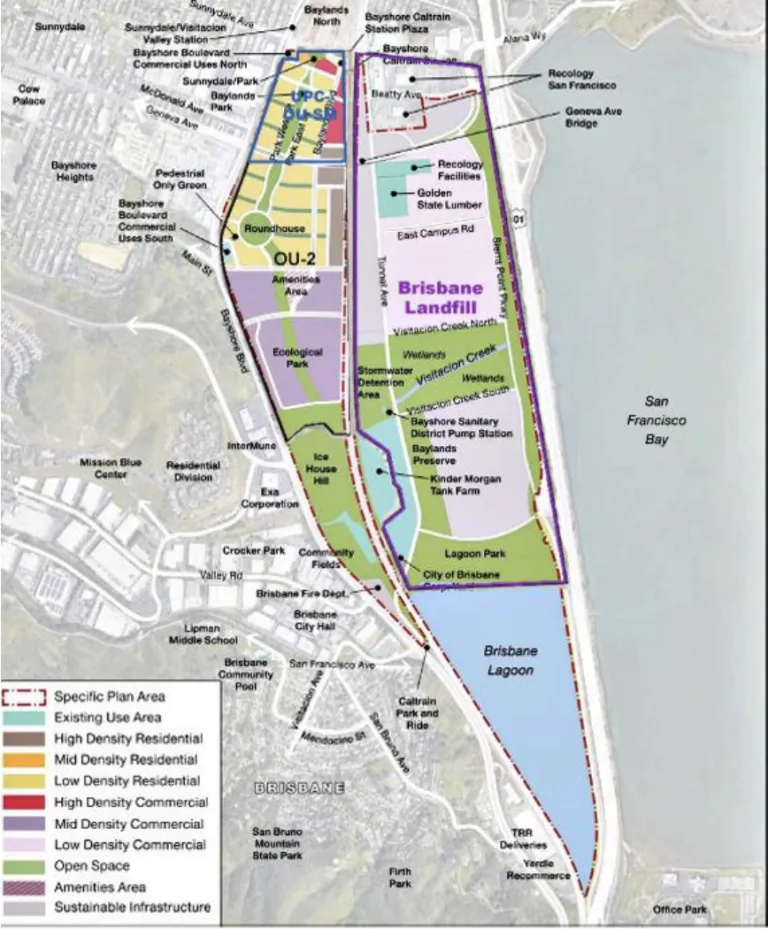
Figure 1: Operable Units Overlaid on Proposed 2025 Land Use Map (Geosyntec, 2021)
With two regulatory agencies (DTSC and RWQCB) directing remediation, cleanup requirements are inconsistent among the OUs and not equally health-protective. For example, the soil cleanup levels (CULs) for UPC-OU-SM apply to all soils to a depth of 5 feet below future ground surface55, while those for OU-2 apply only to uncapped soils.56 The latter could expose future construction workers to persistent contaminants if they need to work on utilities beneath a hardscaped area or beneath buildings. The discrepancy in CULs also makes it impossible to evaluate total impact for a future worker or resident that spends time throughout the Specific Plan area. Thus, the statement that cumulative impact for HAZ-1 is insignificant is not supported. The DEIR should also establish a uniform set of cleanup standards that are protective of human health for each applicable land use. In addition, the DEIR should provide additional detail on what measures are considered acceptable for “eliminating the exposure pathway for future receptors”, as stated in DEIR Section 5.1.
The DEIR should add the specific requirements of Sections 4.2.3 of the UPC-OU-SM and OU-2 FS/RAPs, which specify that locations with CVOCs in groundwater should perform site-specific sampling and risk assessment. The results of that assessment should be used in the design of appropriate mitigation measures. It is not appropriate to allow projects to bypass the requirement for a site-specific soil vapor assessment by “blocking or minimizing the vapor intrusion pathway”, as stated in DEIR Sections 2.3.2 and 5.1. The DEIR should follow the 2023 guidance from the California Environmental Protection Agency (CalEPA) Vapor Intrusion (VI) Workgroup on risk evaluation for future buildings.57 The guidance states that subsurface sampling, risk assessment and remediation should take place before mitigation design.
The DEIR should use updated CULs in cases where the FS/RAPs make use of outdated sources for health risk assessment. In particular, the CUL for arsenic in soil is not the currently recommended value and is not health-protective. The UPC-OU-SM and OU-2 FS/RAPs use a 19 mg/kg CUL, based on a soil background concentration used in a Schlage OU FS/RAP approved by DTSC in 2009 (not available online). The 19 mg/kg value is reported to come from a 2009 study of East Bay soils by Lawrence Berkeley National Labs (LBNL)58; however, that value does not appear in the source paper. The RWQCB recommends a background soil arsenic value of 11 mg/kg, based on a 2011 study that analyzed a wider range of soils throughout the Bay Area.59 That study notes that soils in the northern peninsula tend to be toward the lower end of the range of concentrations. Since arsenic drives most of the health risk for soils, the DEIR should use the more health-protective value as the CUL. Use of an 11 mg/kg CUL would make the CUL consistent with the Import Criteria for the clean soil cap. It makes no sense to allow surface soils in uncapped areas to contain more arsenic than “clean cap” soil relocated from the landfill soil piles.
Consolidation of contaminated soils to an onsite location beneath a cap was not addressed in the health risk assessments and creates risks for future construction workers. Unlike storing TPH-contaminated soils onsite for purposes of biodegradation, metals will not attenuate over time. They will remain in the soil and pose a risk to future workers tasked with installing or repairing underground utilities. If this method of remediation is selected, there should be strong institutional controls to prevent disturbance of the cap, and the soils should not be placed in locations that may be affected by future sea level or groundwater rise.
Impact of groundwater rise on mobilization of contaminants
As groundwater rises in response to SLR, it can dissolve contaminants from the soil column and carry them to different locations. The Brisbane Landfill is required by RWQCB Order R2-2022-0031 to prepare a Long-Term Sea Level Rise Adaptation Plan, but the DEIR fails to address groundwater rise for either UPC-OU-SM or OU-2. Adding a clean soil cap will prevent direct contact of residents and workers with contaminated groundwater but will not stop groundwater from rising within the soil column. The DEIR should add an impact analysis to Hydrology and Water Quality, Section 4.14 in HWQ-4 (Release of Pollutants due to Flood or Tidal Action, SLR-induced Changes to Groundwater, Tsunami or Seiche). Such analysis would apply to the hazard locations discussed here while including the entire Baylands site, addressing the potential for groundwater rise to change flow patterns within the shallow aquifers and landfill, and to increase volatilization of soil vapors from CVOC-contaminated groundwater. [Additional groundwater discussion in text that follows.]
Operable Unit UPC-OU-SM
Soil and groundwater within this OU are contaminated with metals, PCBs, and oil-related hydrocarbons associated with historical railroad and other industrial uses. Groundwater is impacted by a plume of CVOC contamination originating from the Schlage Lock site north of the Specific Plan area. The following comment applies to this OU.
The DEIR should clarify the remediation status of the Schlage Lock site groundwater plume and its impact on the UPC-OU-SM cleanup, The DEIR (page 4-13.1) makes the following statement regarding CVOC contamination:
Finally, remediation of the existing chlorinated volatile organic compounds (CVOC) groundwater plume within the Baylands is being addressed as part of the Schlage Operating Unit in San Francisco, which has undergone environmental review and been approved by the RWQCB.60
Based on positive results of active groundwater treatment, in 2008 DTSC approved the decommissioning of the groundwater monitoring well network and soil vapor extraction system, and discontinuation of in-situ groundwater treatment. However, a 2023 Five-Year Review found that concentrations of chlorinated VOCs (CVOCs) are above CULs in both the Colma and Merced formations.61 The most recent reported groundwater sampling event (3rd Quarter 2024) measured 10,000 μg/L trichloroethene, 3,900 μg/L of cis-1,2-dichloroethene, and 1,700 μg/L of tetrachloroethene in Well 25B, screened in the Upper Colma Foundation directly north of UPC-OU-SM.62 DTSC concluded that natural attenuation would not reduce concentrations below CULs in the expected timeframe and is now requiring installation of a new monitoring well network and additional active groundwater treatment.
As there has not been effective control of this source of groundwater contamination in the 40 years since the contamination was first investigated, the DEIR should discuss in detail the impact on feasibility and the timeline for achieving soil vapor CULs.
Section 4.14 - 4.15: Hydrology and Water Quality, and Geology, Soils, and Seismicity
On the subject of sea level rise, the DEIR is a forward looking document. It demonstrates that intention in impact analysis of regulation that includes OneShoreline’s Planning Policy Guidance and the requirements of BCDC’s Regional Shoreline Adaptation Plan (RSAP).
Separated from the Bay by only U.S 101 and the Sierra Point Parkway and with almost the entire Baylands site built upon historical Bay wetlands, SLR impacts are of substantial concern.
The Baylands major rehabilitation challenges have been described in detail and are required prior to any development, particularly on the landfill but also the lands of the former railroad yard and Schlage. The DEIR addressed those actions with a suite of technical reports, relevant discussions and impact analysis. We found that information very informative. On the subject of SLR, we have concerns that certain issues were insufficiently considered, thereby not addressed in Specific Plan policy or Threshold mitigations.
Shallow Groundwater and Associated Risks of Sea Level Rise
Shallow groundwater or aquifers lie beneath the entire Baylands site, existing within soil layers of sand, gravel and/or other permeable soil types in layers above and/or below young bay mud. The existing depth-to-water for groundwater varies by location and as reported in the technical studies.63 The DEIR sets a SLR target (per Ocean Protection Council guidelines) at the year 2100. The DEIR commonly presents data as either existing and 2100 without mention that SLR changes are already underway and will gradually become physically evident in the Baylands. Over the upcoming 75 years, SLR-driven impacts will year-by-year become evident. That said, the Brisbane Baylands need Specific Plan guidance to support incremental and timely actions.
Every parcel will need a site-specific baseline of the depth-to-water baseline before development in order to assess how soon that site may be vulnerable. This same data applies equally, to City property and infrastructure such as roadways, with planning needed for timely mitigation of groundwater risk and to minimize future emergency events. The Specific Plan needs to set a policy with the baseline requirement or incorporate it as mitigation in impact analysis.
In a report prepared for the City of Sunnyvale, the San Francisco Estuary Institute described a set of impacts or rising groundwater.64 We discuss several relevant impacts here, with reference to the Brisbane Baylands project.
Liquefaction. From GEO-3: “Analysis of Baylands soils data determined that liquefaction susceptibility is present throughout the site,” The entire Baylands site is at high risk of liquefaction now and more so as rising groundwaters make soils less stable. This issue is discussed in the Geology & Soils section and mitigated as MM-GEO-3, primarily using applicable California Building Codes. Property owners should be informed of their site’s vulnerability prior to development with a required site-specific groundwater level assessment.
Contaminant mobilization. The DEIR and our prior comments about Hazards and Hazardous Waste have described substantial presence of buried hazardous waste in the soils below the Baylands site. Upon encountering such waste, rising groundwater may transport it horizontally or vertically, possibly into previously uncontaminated locations or releasing to the surface, potentially exposing people or stormwater. The DEIR needs to discuss and mitigate this impact in the Hydrology and Water Quality in HWQ-1 and/or HWQ-4.
Flooding due to emergence or ground saturation. The science findings of recent years about SLR-related shallow groundwater, have added a flooding factor that now needs to be considered in addition to extreme storms and SLR. Correctly, the DEIR sets requirements for using pervious surface treatments, encouraging recharging and reduction of runoff. Saturated soils that may result from either/both storms and rising groundwater will exacerbate flooding conditions, increases to runoff that produce ponding on lowlands and roadways. Rising groundwater itself may emerge at low points, also producing the same impacts. Around the Bay, examples of such impacts already occur each winter.(Note- add a photo example if I can find one). The DEIR needs to analyze and mitigate for flooding impacts of rising groundwater in HWQ-3.
Recommendations
We recommend (1) that the DEIR include a map displaying currently known depth-to-water data everywhere within the Baylands Project site and (2) that a site-specific requirement be established requiring a shallow groundwater hydro-geologic technical report prior to development on any Baylands parcel.
Section 4.16: Utilities, Service Systems, and Water Supply
Monitoring and Curtailment Related to Cal Water’s Development Offset Program
There appears to be no guarantee that water supply projects related to Cal Water’s Development Offset Program can provide the 1,146.3 acre-feet per year (AFY) additional water demand estimated for the Specific Plan at build-out (see Table 4.16-2 on page 4.16-6) in addition to water demand for other developments participating in the offset program.
On page 4.16-39, the DEIR says “Cal Water will verify compliance with the Development Offset Program (i.e., ensure that all payments for offsets are completed) prior to establishing a water service connection.” However, there is no discussion of how the offset program is monitored or what will happen if offset projects are not able to be developed or do not deliver the estimated quantity of water. Cal Water should not assume net zero increase in potable demand. The EIR needs to specify a monitoring program to guarantee water supply as follows:
Track new supplies developed for the offset program vs. demand for new development participating in the offset program (with approved building permits). Water supply projects need to be online, or sufficient reduced non-rationing demand from conservation needs to be achieved before construction occurs in the Baylands Specific Plan area.
Monitor success of new supplies over time to verify that the estimated new supply from offset projects really is delivered, and update tracking as needed.
Require water demand estimates as part of application materials for individual projects. Once occupancy is approved for new development supplied through the offsets, monitor water usage for each site to verify that the use is not exceeding projected demand, and update tracking as needed.
Require both offset supplies and Specific Plan demands to be monitored in perpetuity through annual reports.
Require the developer to contribute additional offset fees If new high water demand uses are proposed that will increase water usage for the Specific Plan area beyond 1,146.3 AFY.
Trigger a moratorium on new building permits (curtailment) for development projects that rely on the Development Offset Program for water supply until new supply is brought online and verified in the event monitoring shows that new demand would not be met by offset program supply.
We were unable to find any documentation describing such monitoring for the offset program. If such documentation exists, it should be included in the DEIR. If such activities are not documented, they need to be documented in the EIR to show that the offset program really will provide the water supplies needed for the Specific Plan.
These monitoring and curtailment requirements should be included as a mitigation measure for the Brisbane Baylands Specific Plan project. Otherwise, water supplies available to California Water Service Company’s South San Francisco District could be insufficient to serve full buildout of the Baylands Specific Plan. Without this mitigation, water supply impacts should be identified as significant and unavoidable.
Water Supply Assessment for New Middle School and Fire-fighting
The Water Supply Assessment (WSA) in Appendix P does not include an assessment of water demand for the new school to be developed in the Brisbane Baylands Specific Plan area. According to the DEIR, the Baylands Land Use Program includes a new Middle School for 350 students (see Table 3-1c on page 3-14). Water supply for the school needs to be included and assessed in the WSA and reflected in the Final EIR.
The WSA also does not include any discussion of water use for fire-fighting. Future water demand for fire-fighting should be analyzed and any expected increase in water use for this purpose added to the total projected demand for the Specific Plan area in the Final EIR.
Other
Cal Water’s developer offset fee was set in 2022. Costs for offset program supply projects should also be re-evaluated every two years and the offset amount increased accordingly. Otherwise, other rate-payers could be charged for projects that do not benefit them. This is especially important given significant inflation that has taken place in the past three years.
Inadequate Analysis of Foreseeable, High Impact Land Uses
Cross-reference: The DEIR fails to account for the unusual water demands of biotech and data centers. See Land Use section, above, for discussion of impacts and recommended standards.
Section 4.18: Parks, Open Space/Open Areas, and Recreational Resources
The DEIR’s analysis of parks, open space, and recreational resources under Threshold REC-1 is incomplete and does not satisfy CEQA’s requirement to disclose and evaluate all potentially significant impacts.
Over-reliance on Acreage Standard
The DEIR concludes that the project will have a less-than-significant impact because it maintains a parkland ratio of 5.03 acres per 1,000 residents (increasing to 13.2 acres at buildout). Reliance on a simple acreage ratio is an inadequate metric for evaluating deterioration. This approach does not account for whether park facilities and natural areas can withstand increased use, nor does it consider the quality, distribution, or environmental sensitivity of parkland. CEQA requires a substantive analysis of whether “substantial physical deterioration” could occur (CEQA Guidelines §15126.2[a]).
Lack of Criteria for “Deterioration”
The DEIR provides no definition or criteria for when a park or recreational facility should be considered “deteriorated.” Without such standards, the analysis cannot reasonably determine whether increased population and use will result in significant physical effects. Both recreational wear and environmental degradation (erosion, habitat disturbance, trail impacts) must be considered.
Omission of trail design and siting impacts
The DEIR acknowledges that new trails will be developed at Lagoon Park, Ecological Park, Visitacion Creek, Icehouse Hill, and Baylands Preserve (see Table 3-1d). However, the analysis does not address how these trails may affect surrounding habitats or contribute to deterioration of resources. This omission is inconsistent with policies in the San Mateo County Trails Plan, which specifically require proposed trails to be reviewed for potential environmental impacts under CEQA. The DEIR also fails to incorporate the San Francisco Bay Plan’s Public Access Policy, which directs that access “should be carefully evaluated in consultation with appropriate agencies to determine appropriate location and type of access.”
Failure to integrate habitat restoration considerations
Habitat restoration and enhancement are central elements of each of the Baylands parks. Trail placement and intensity of human use have direct implications for the success of restoration and long-term ecological resilience. CEQA requires that these potential conflicts be disclosed and analyzed (Guidelines §15126.2[a]), yet the DEIR does not assess how increased use and new trail alignments may undermine restoration objectives.
Recommendation
The DEIR must (1) establish clear, objective criteria for identifying when a facility or park is considered “deteriorated,” (2) evaluate trail impacts in light of SMCTP and Bay Plan policies, and (3) expand its analysis to include the relationship between recreational use, habitat restoration, and ecological sensitivity. Without this analysis, the DEIR does not provide sufficient information to support a less-than-significant finding, nor does it identify feasible mitigation measures to reduce impacts.
Thank you for considering these comments.
Respectfully,
Gita Dev
Chair, Conservation Committee, Sustainable Land Use Committee
Sierra Club Loma Prieta Chapter
Jennifer Hetterly
Campaign Coordinator
Sierra Club Bay Alive Campaign
Eileen McLaughlin
Board Member
Citizens Committee to Complete the Refuge
Alexandra Mendoza
Environmental Associate
Green Foothills
Chris MacIntosh
Conservation Chair
San Mateo County Bird Alliance
1 Laurel Heights Improvement Ass’n v. Regents of Univ. of Cal., 47 Cal. 3d 376, 396–99 (1988).
2 Congressional Research Service : Oversight of High-Containment Biological Laboratories
3 CDC & NIH, Biosafety in Microbiological and Biomedical Laboratories (BMBL), 6th ed. 2020 — Chapter 2 (Engineering Controls, pp. 29–45) and Chapter 3 (Biosafety Levels, pp. 46–84)
4 https://mygreenlab.org/resources/water/
5 https://pmc.ncbi.nlm.nih.gov/articles/PMC11078267/
6 https://www.nature.com/articles/d41586-024-02899-0
7 High-Containment Biosafety Laboratories: Preliminary Observations on the Oversight of the Proliferation of BSL-3 and BSL-4 Laboratories in the United States Congressional hearings, US Govt. Accountability Office
8 U.S. EPA, Report to Congress on Server & Data Center Energy Efficiency (2007).
10 Zheming Tong and K. Max Zhang, “The Near-Source Impacts of Diesel Backup Generators in Urban Environments,” Atmospheric Environment 109 (2015): 262–71.
11 CARB, Air Quality and Land Use Handbook (2005), 11-15.
12 Laurel Heights Improvement Ass’n v. Regents of Univ. of Cal., 47 Cal. 3d 376, 396–99 (1988).
13 CEQA Guidelines § 15126.4(a)(1)(B).
14 City of San Carlos Ord. 1520 (2021); Redwood City Zoning Code § 30.19 (2021).
15 CDC & NIH, Biosafety in Microbiological and Biomedical Laboratories (6th ed. 2020).
16 BAAQMD Reg. 7: Odorous Substances (2021).
17 CARB, Air Quality and Land Use Handbook (2005).
18 Ibid
19 BAAQMD Reg. 7: Odorous Substances (2021).
20 ANSI/ASSP Z9.5-2022; NFPA 45 (2019).
21 Cal. Energy Code (Title 24, 2022); ASHRAE 90.4-2019.
22 Google, Environmental Report 2022; Meta, Data Center Fact Sheet (2022).
23 Ibid.
24 Ibid.
25 SFPUC, Non-Potable Water Ordinance (2015); SFPUC, Alternate Water Source Guidebook (2018).
26 CARB ATCM for Stationary Compression-Ignition Engines, 17 CCR § 93115; BAAQMD Reg. 9, Rule 8; EPA Tier 4 Standards.
27 Northern Virginia is home to the world's largest concentration of data centers. Virginia law has put limitations on data center locations primarily due to noise pollution. In Fairfax County, Va.,setbacks are required between data center buildings and any residential property line and experts must conduct noise studies before and after data center construction to ensure noise regulations are met, and all equipment must be behind a barrier that further reduces noise.
29 CARB ATCM to Limit Diesel Idling, 13 CCR § 2485; AB 98 (2024).
30 Ibid.
31 Ibid. Section 2485 sets a maximum idling limit of 5 minutes statewide, but permits stricter facility rules.
32 SCAQMD Rule 2305 (WAIRE), EPA SIP approval (2023).
34 City of Fontana, Resolution No 2019-158, Truck Impact Fee Program (2019).
35 Healthy Jobs / Housing Balance - According to the Building Industry Association and the California Department of Finance, a healthy jobs / housing balance is 1.5. (One full-time job and one part-time job per housing unit). Any ratio above 1.5 jobs per unit signifies there is an insufficient number of units to meet the needs of the local workforce. Even if there is a numerical Jobs / Housing balance, there is often an imbalance in Jobs / Housing Fit (where employees do not have high enough income to afford the housing in their community). Jobs / Housing Fit should be taken into consideration when reviewing any new commercial developments.
36 [ii] 6.5 M SF Commercial @ 300 SF/job (for biotech or similar jobs that require larger spaces) + 500,000 Hotel @ 1,000 SF/job
37 6.5 M SF Commercial @ 150 SF/job (for typical office and tech support jobs) + 500,000 Hotel @ 1,000 SF/job
38 One unit per every 2 employees
39 One unit per every 1 1/2 employees (assuming not all units will house more than one employee)
40 San Francisco’s 2023-2031 RHNA mandates the creation of more than 82,000 units within the city, broken down into targets by income group.....This assessment is based on San Francisco’s unmet housing need at every income level and projected population growth. San Francisco General Plan, Housing Element
41 Mountain View, East Whisman Specific Plan: To achieve balanced growth, the Plan contains a Jobs/Housing Linkage program to encourage office and residential growth to occur in tandem. This mechanism requires new office development to facilitate residential development and promotes integration of housing into the area
42 Hawk vision: https://www.azandisresearch.com/animal-vision/hawk/
43 Sharing Space: Balancing Public Access and Habitat Enhancement at the Palo Alto Horizontal Levee Pilot Project. https://www.youtube.com/watch?v=3KXgOWuUrQA
44 Menlo Park Pond R4, South Bay Salt Pond Restoration Project: https://www.southbayrestoration.org/page/salt-pond-tidal-marsh
45 Adaptation Science, San Francisco Estuary Institute: https://www.sfei.org/programs/rl/baylands-shoreline-resilience/adaptation-science
46 Interagency Meetings, US Army Corps of Engineers San Francisco District: https://www.spn.usace.army.mil/Missions/Regulatory/Interagency-Meetings/
47 DEIR p.4.6-55: “Program EIR Mitigation Measure 4.A-4a. Nighttime lighting would therefore be directed downward, and light trespass into habitat areas would not exceed the brightness of a full moon.”
48 Wolfe, J.L., The Influence of Lunar Light on Nocturnal Rodent Activity (1989) (quantifying activity suppression across moon phases).
49 Baylands Specific Plan DEIR Table 4.9-14 and pages 4.9-86 thru 88
50 DEIR, Chapter 4 Air Quality, p. 4.9-17
51 Roadside Vegetation Design to Improve Local, Near-Road Air Quality National Institutes of Health, PubMed, May 2017
52 DEIR, p. 4.3-55.
53 DEIR, p. ES-108.
54 Urban cities and road traffic noise: Reduction through vegetation, Science Direct
55 Geosyntec, 2021a. Feasibility Study/ Remedial Action Plan, San Mateo County Portion of Universal Paragon Corporation Operable Unit (UPC-OU-SM), Brisbane, California. October 11, 2021.
56 Geosyntec, 2021b. Final Feasibility Study/ Remedial Action Plan, Brisbane Baylands Operable Unit 2, Brisbane, California. December 22, 2021.
57 Cal EPA, DTSC, and RWQCB, 2023. Supplemental Guidance: Screening and Evaluating Vapor Intrusion, FINAL DRAFT. https://dtsc.ca.gov/wp-content/uploads/sites/31/2023/02/VI_SupGuid_Screening-Evaluating.pdf
58 LBNL, 2009. Analysis of Background Distributions of Metals in the Soil at Lawrence Berkeley National Laboratory. D. Diamond et al. 2002, Revised 2009, Lawrence Berkeley National Laboratory Environmental Restoration Division.
59 Duvergé, D. J. 2011. Establishing Background Arsenic in Soil of the Urbanized San Francisco Bay Region. December 2011.
60 The lead agency for the Schlage OU remediation is DTSC, although RWQCB is incorrectly listed as case manager in Geotracker.
61 Geosyntec, 2024. Responses to DTSC Comments on Five-Year Review Recommendations Implementation Report, Former Schlage Operable Unit, Brisbane and San Francisco, California.
62 Geosyntec, 2025. Geosyntec Consultants, Inc., TECHNICAL MEMORANDUM, Schlage OU and UPC OU-SF, Response to DTSC Comments – 3rd Quarter (August) 2024 Groundwater Monitoring Report (Dated 13 December 2024)
63 IGeosyntec. 2022a. Groundwater Modeling to Evaluate Potential Influence of Sea Level Rise on Groundwater Level
64 Groundwater and Sea Level Rise Addendum, Appendix G,to the Moffett Park Specific Plan, SFEI for the City of Sunnyvale, November 2021: https://www.sunnyvale.ca.gov/home/showpublisheddocument/5989/638844519741000000