Mallows Bay - Potomac River National Marine Sanctuary will be the first new National Marine Sanctuary in nearly 20 years - and the first ever on the Chesapeake Bay.
National Marine sanctuaries are where monitoring and research take place to enhance our understanding of natural and historical resources and how they are changing. Thus they contribute to building a stronger, more resilient future for America's communities, ecosystems and economy.
The Maryland Sierra Club strongly supports this nomination and, in particular, Alternative D which would include the Mattawoman Creek and Chapman Forest shoreline.
We support a visitors center in the town of Indian Head, where infrastructure is in place and will foster revitalization. D includes more public access for fishing, recreation, education, research and tourism and will protect Mallows Bay from overcrowding by providing more destination points.
Please support the nomination by visiting the National Oceanic and Atmospheric Administration's (NOAA) comment site before the March 31, 2017 deadline and submitting a comment such as the following:
Paste: I support designation of the Mallows-Potomac National Marine Sanctuary, and believe Alternative D offers the best opportunities for access, education, tourism, research, and recreation.
Here is a Step by Step Guide to submitting comments on the NOAA website.
And here is Additional Information to add to your comments to NOAA in support of Alternative D for the National Marine Sanctuary.
You can also attend the upcoming Public Meetings on the Draft Environmental Impact Statement March 7, 2017 6 PM - 9 PM Charles County Government Building and March 9, 2017 6 PM - 9 PM Anne Arundel Community College
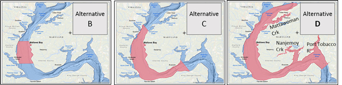
During the scoping process for the sanctuary, there was strong support for a sanctuary larger than the original nomination. This original nomination is now called Alternative B in the Draft Environmental Impact Statement or "DEIS." (Alternative A is no sanctuary at all). NOAA has identified Alternative C as its "preferred alternative." This alternative is considerably larger than the original nomination, yet lacks any sub-estaries. Alternative D adds many more opportunities for public access, education, tourism, and research.
Mallows-Potomac proposed National Marine Sanctuary
The system of National Marine Sanctuaries presently comprises 13 sanctuaries and a national monument ranging in size from one to thousands of square miles. The sanctuaries are administered by the National Oceanic and Atmospheric Administration (NOAA) in partnership with local, state, and nonprofit agencies.
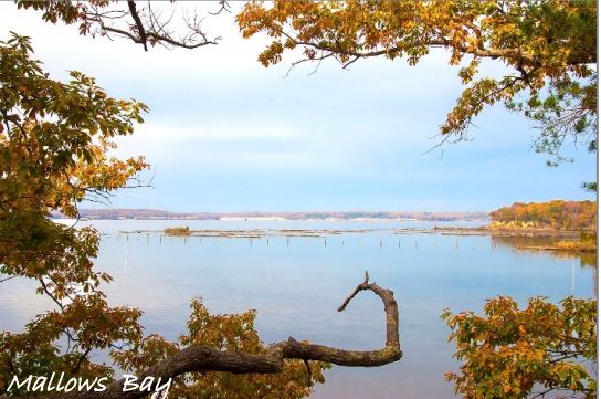
The Mallows Bay-Potomac River sanctuary is centered on the largest ship-wreck fleet in the western hemisphere, the "Ghost Fleet of Mallows Bay." As a result of public comments during the scoping process completed in 2016, NOAA is presenting three alternative sizes for the sanctuary (B, C, and D, mapped above).
Maximizing opportunities
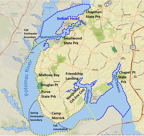
A large number of groups and individuals have recommended a sanctuary like Alternative D because it would greatly enhance the sanctuary's goals of promoting fishing, recreation, education, research, and tourism. The map below compares Alternative C (yellow dashed line) with Alternative D (blue dashed line). Included in "D" are the valued and calm sub-estuaries of Mattawoman Creek, Nanjemoy Creek, and the Port Tobacco River. These estuaries and the intervening section of the tidal Potomac River figure prominently in the Nationwide Rivers Inventory “judged to be of more than local or regional significance" by the National Park Service.
If designated, Alternative D would still be only the 4th smallest of all sanctuaries. But as outlined below, and detailed here, it would include many remarkable opportunities for tourism, research, education, and recreation.
Learn more from NOAA on the proposed Mallows-Potomac National Marine Sanctuary
Learn more from Maryland's Dept. of Natural Resources
Learn more detail about what's included in Alternative D.
Alternative D adds many features
By including three sub-estuaries, "D" greatly enriches the sanctuary:
- Ecologically it adds globally uncommon freshwater tidal marshes, fish nurseries, and a broader range of salinity. Hence its value as a Sentinel Site soars.
- It adds seven additional access points in safe protected waters. Not only does this afford opportunities for tourism and educational activities, but it also alleviates possible crowding and overuse of the Mallows Bay site itself.
Maritime and cultural heritage is also enhanced with verified Native American occupation sites, two likely landing locations of Captain John Smith, about 18 additional shipwreck sites dating to the 1700's, seven "lost fisheries" (including a caviar facility), two civil-war shore batteries, and the escape route of John Wilkes Booth.
Finally, by encompassing Indian Head, it affords possibilities for the town's revitalization as a trail destination town and location of a sanctuary headquarters.
Opportunities for education, tourism, recreation & benefits for town of Indian Head
Education
- Leverages and supports ongoing programs such as outdoor education at Chapman State Park and the Nanjemoy Creek Environmental Center
- Expands the range of habitats and ecological regimes, including nearly the full wintering range of the endangered Shortnose Sturgeon.
- Adds access points to reliably safe and quiet waters in sub-estuaries for long-scheduled field trips.
Marine heritage & nature tourism
- Alternative D adds about 18 sites where ships are known to have sunk, dating back to the 1700's.
- Includes areas of operation of the 1st ‘aircraft carrier’ that launched spy balloons in the Civil War from a barge near Mattawoman Creek.
- Supports the revitalization of Indian Head through tourism, including a visitor center, which would also relieve rural Mallows Bay of crowding pressure.
- Water trails: more extensive use of the John Smith Trail; Potomac Heritage Trail; Star Spangled Banner Trail.
- Land trails: more extensive range for the Religious Freedom Byway and bicycle-touring route on Route 224. Adds the John Wilkes Booth land & water escape route.
 Adds extensive tidal-freshwater marshes. These include Mattawoman's ‘breadbasket marshes’ once employed by Native Americans and the only site on the western shore with a natural population of American Lotus.
- Adds many Native American archaeological sites along Mattawoman and Nanjemoy Creeks and Port Tobacco River and five additional towns mapped by Capt. John Smith.
- Adds three state parks, a county park, a town park, Mattawoman Wildands, and three Wildlife Management Areas connecting to water.
- Adds sites of historical fisheries, including the Shad and River Herring at Chapman Point (Chapman State Park) and a caviar fishery at Glymont.
Research
- Adds baseline fisheries research, esp. for Mattawoman and in the Potomac via seine surveys.
- Adds year-round tidal freshwater where many migratory marine fish species spawn.
- Hotspot for spawning by striped bass and other migratory-fish.
- Ideal sentinel site.
An ideal Sentinel Site
From the NOAA website:
“National marine sanctuaries are where monitoring and research take place to enhance our understanding of natural and historical resources and how they are changing… In that sense they are what we call 'sentinel sites' and are focal points for both the scientific and resource management communities.”
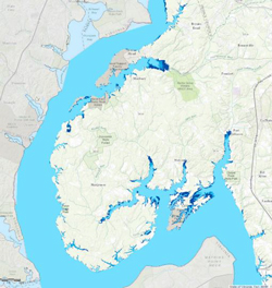
Alternative D would enhance the sanctuary’s value as a sentinel research site because it would then include much more brackish "mesohaline" water, and would add year-round tidal freshwater (see map above). This transition is ecologically rich, esp. the globally uncommon tidal freshwater. Here striped bass produce the 2nd highest number of eggs in the Chesapeake Bay, of national significance considering the Bay produces up to 90% of the Atlantic Ocean's striped bass.
 Other important marine species like Alewife Herring also spawn here (map to right), and the federally endangered shortnose sturgeon has been detected near Mattawoman Creek & Chapman State Park. Further, sub-watersheds range from Nanjemoy’s forested “reference” to Mattawoman’s, where warning signs of urbanization are seen as a faltering of its famous anadromous fish nursery.
The sanctuary would be uniquely suited to monitor ecosystem response to shifts in brackish boundaries and marsh flooding expected with sea-level rise. See darker blue areas in map below copied from the MERLIN mapping app.