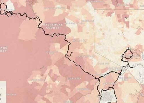
The Baltimore Metropolitan Council (BMC), on behalf of the Baltimore Regional Transportation Board, commissioned the Toole Design Group to map a continuous trail called the Patapsco Regional Greenway (completed proposal is online as a PDF). The trail would extend 30 miles, from Sykesville to the Inner Harbor, and would follow the Patapsco River and be inside the Patapsco Valley State Park for most of the route (image from page 10 of the PDF, below).
The Sierra Club support group, Preserve Patapsco Valley State Park, reviewed the Patapsco Regional Greenway PlanPosition Statement on Patapco Regional Greenway Plan
by Tim Maguire and Joanne Heckman, February 7, 2018
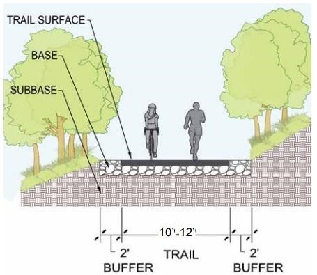
The proposal is for a series of trails that are 10-12 feet wide (with 2-foot buffers) and meet the requirements of the Americans with Disabilities Act. This typically means a paved surface (image from page 23, shown below).
The stated purposes of the Patapsco Regional Greenway are: to increase tourism, to promote bicycle commuting, and to benefit local businesses.
The Sierra Club position is that these goals, especially the latter two, are not consistent with the mission of the Maryland Park Service for “wise stewardship and enjoyment by people”. The DNR’s stated goals for parkland are: "natural resource conservation, cultural and historic preservation, watershed protection, education and interpretation and nature-based outdoor recreation, including: trails, picnicking, boating, camping, cabins, hunting, fishing and swimming." (2016 DNR Acreage Report: http://dnr.maryland.gov/land/Documents/Stewardship/CurrentAcreageReport.pdf.)
Does commuting count as enjoyment or nature-based outdoor recreation? The Greenway is touted as a bike route for commuters, though no research was presented to substantiate this. It’s hard to imagine people commuting on a route that includes no homes or businesses, passing through a closed and unlighted state park morning and night (which requires getting a permit from DNR). The statement that the Park’s Grist Mill Trail has become a notable bicycle commuter route “by connecting residential areas to employment centers” (page 6) is absurd, since the trail extends from a vacant lot into the center of the Park.
Grist Mill Trail: Ilchester Road to Avalon Area
Below Ellicott City, the Greenway proposal calls for paved trails all the way to the Inner Harbor. This directly contradicts the DNR’s Trail Vision for PVSP, which specifies single-track natural-surface trails.
In addition, many of the proposed trail sections seem unrealistic: converting River Road to a one-way road with a bike lane; building a bike lane on an active railroad line; and building 12 bridges using the piers remaining from former (now destroyed) bridges. Using utility line right-of-ways as bike paths seems dubious, as does the statement, “If properly protected, roadway shoulders can be designated as greenway” (page 8).
What’s more, the cost estimate of $139 million doesn’t include feasibility tests of all the proposals (including the bridges). The suggested funding sources -- American with Disabilities Act (ADA) funds, Public Safety Works Program, American Conservation Corps volunteers, the Bicycle Retrofit Fund, and Boy Scouts of America -- also seem far-fetched.
The Greenway plan acknowledges the importance of limiting environmental impacts, but then proposes trails directly on the Patapsco River banks, such as along Lost Lake (page 63) and in the “artistic gateway” near the Elkridge Bridge (page 67). Near Halethorpe, a boardwalk is proposed, to be built in the wetlands (page 68). Retaining walls and bridges would be required along Mill Race Trail (page 55).
This is to say nothing about the environmental impact of clearing and paving trails 10-12 feet wide with 2 feet of buffer on either side. This is 16 feet of hard surface, the width of a one-way road, and meant to extend for miles through the Park.
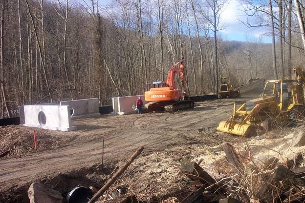
Grist Mill Trail under construction; photograph by Greg Griesman
A single-track natural-surface trail allows people to enjoy the park with some expectation of quiet and privacy. Paved roads into the park invite crowds, noise, litter, and invasive plant species. A well-designed dirt trail controls runoff and prevents erosion, unlike paved surfaces. Pavement also disrupts the ecology; it interrupts the connectivity of the plant and animal communities, and breaks up the closed tree canopy.
Calling a bikepath through a state park a “greenway” is also misleading. The DNR has defined what a state park is, but has no definition for a “greenway”. The dictionary definition is “a strip of undeveloped land near an urban area, set aside for recreational use or environmental protection”.
This is exactly what Patapsco Valley State Park is already. The proposal to create a “greenway” inside preserved parkland is a misuse of the term. The Park is already green, and putting a trail through it can only make it less green. The Patapsco Regional Greenway plan doesn’t propose adding more land to the Park. It only proposes converting existing undeveloped land into ADA-compliant trails.
A greenway outside the Park, on the other hand, could actually create natural areas where none currently exist: for example, along an unused railroad track. If a greenway like that encouraged walking and biking, either for transportation or recreation, it might reduce traffic and the need for more roads. Routed through commercial and residential areas, it might actually promote tourism and business as well.
Even without the green space, biking and walking are good for the environment. The report proposes to create safe bike lanes in downtown Baltimore (pages 81, 85, 87). The Sierra Club promotes clean transportation alternatives like this.
The Sierra Club supports bike lanes on roads and greenways outside state parks, natural environmental areas, and wildlands. The Patapsco Valley State Park is an irreplaceable natural resource in an increasingly urbanized location. Our position is that each proposed segment of the Patapsco Regional Greenway plan should be analyzed independently, and the environmental impact compared to the purported benefits. Areas outside the Park, especially those that might serve as green corridors between disconnected sections of the Park, might be good candidates for greenways. Areas deep within the Park, far from commuter destinations or businesses, might be better used as unpaved natural areas.


