
November 29, 2023
Makena Wong
OneShoreline Project Manager
1700 S. El Camino Real, Suite 502
San Mateo, CA 94402
Transmitted via email: Projects@OneShoreline.org
Re: NOP Comment: Millbrae and Burlingame Shoreline Area Protection and Enhancement Project EIR
Dear Ms. Wong,
The Sierra Club Loma Prieta Chapter’s Bay Alive Campaign welcomes this opportunity to comment on OneShoreline’s October 10, 2023 Notice of Preparation (NOP) of an Environmental Impact Report (EIR) for the Millbrae and Burlingame Shoreline Area Protection and Enhancement Project (the Project). We do so on behalf of tens of thousands of Sierra Club members and supporters who share our commitment to protect the health of our communities, our wildlife and our Earth by promoting living shorelines, healthy waters, and just, equitable solutions to sea level rise in the San Francisco Bay Area. Our Bay Alive Campaign advocates for the multi-layered benefits of natural and nature-based adaptation to sea level rise, for regional coordination, and for equitable strategies to build community resilience. We contribute to plans, guidance, and actions under consideration at local, regional, and State levels. In addition, we provide Bay-educational webinars by topic-expert presenters for advocates, community leaders and city/county staff and elected officials,1 and we train new advocates through our eight to twelve week Bay Advocate Programs.
We appreciate the efforts of OneShoreline to provide guidance and support for coordinated sub- regional adaptation planning and projects, including taking the lead on a cross-jurisdictional shoreline protection project for this highly vulnerable shoreline area. However, we have been frustrated by a lack of clarity about what, specifically, is being proposed.
We diligently reviewed OneShoreline’s supporting documents to improve our understanding of the Project. Unfortunately, we encountered inconsistencies in the documentation, with numbered alternatives not aligning across various reports. Similarly, the feasibility report drew from analyses in prior reports that did not consistently address the same Project concept or feature. Although we acknowledge the evolving nature of the Project, the lack of a definitive Project description forced us to make assumptions about the intended alternatives and hindered our ability to provide precise scoping comments regarding specific features or locations.
We respectfully submit the following scoping comments based on two, highly generalized Project concept alternatives:
- Offshore Barrier Alternative, and
- Shoreline Alternatives.
PROJECT SUMMARY IS INADEQUATE
Environmental impacts can vary significantly depending on the specific location and the type and design of Project features. The NOP’s summary of the proposed Project is ambiguous and lacks sufficient detail to provide adequate public transparency about what is proposed. As a consequence, the public cannot fully participate through informed, substantive comments on the appropriate scope of environmental review.
In order to ensure transparency and allow stakeholders to provide meaningful input into the Project concept and the scope of environmental review, we ask that OneShoreline rescind and reissue the NOP with a more complete Project concept, informed by outreach to stakeholders, regulators, and the public, that provides definitive descriptions of the Project alternatives and more specific detail about the features to be analyzed, such as
- the principal features of the proposed off-shore barrier, including dimensions, the number, location, and size of tide gates, and the nature, location, and size of specific “habitat features” of the proposed Project,
- the proposed locations, composition, and size for each type of potential shoreline feature and enhancement (trails, beaches, habitat, levees, walls, bridges, tide gates, and pump stations) to be included in all Project alternatives, and
- how the Project is intended to achieve the objective of “promoting healthy and sustainable ecosystems proximate to the Bay shoreline”, i.e. whether the objective pertains only to the so-called “living shoreline” features of the offshore barrier or also includes improving the resilience of existing ecosystems in and near the Project area.
In addition, please clarify ownership of the land and waters within the Project area and provide a parcel map displaying it graphically.
PROJECT SHOULD CONSIDER ADDITIONAL ALTERNATIVES
Section 4.3 of the Project’s Coastal Hazards report discusses “roughness” as a wave runup mitigating factor to consider in regard to sea level rise protection structures.2 However, the analysis does not consider employing natural or nature-based structures to provide that “roughness.” San Francisco Estuary Institute’s (SFEI) San Francisco Bay Shoreline Adaptation Atlas (Adaptation Atlas)3 indicates high potential for nature based sea level rise adaptation strategies such as estuarine beaches, eelgrass beds, and mudflat augmentation in the Project Area.
In discussing this stretch of shoreline, the Adaptation Atlas identifies beaches as a potential adaptation resource for producing roughness. Our own observation of this shoreline finds that there is a substantial extent of persisting rocky beach extending from Mills Creek to Airport Boulevard and elsewhere in the Project's shoreline.4 These vestigial beaches, often covered by inappropriate shoreline reinforcement, can be recovered and potentially enhanced, with the guidance of Bay-qualified estuarine ecologists, to become a flood protection asset.
Additionally, we note that Rincon Consultants provided mapping of historical eelgrass beds5. The Adaptation Atlas also identifies eelgrass as having potential as another resource for providing “roughness” that may reduce wave runup. Finally and highly visible from Baylands Park, the mudflats offshore are extensively broken up as mud berms, another runup mitigating factor mentioned in Section 4.3, Coastal Hazards. We strongly recommend that you involve a science consultant, such as SFEI, taking a closer look at the adaptation opportunities for this shoreline.
- Please evaluate a shoreline alternative that incorporates nature-based solutions to the greatest extent practicable as part of the Project actions. Doing so can achieve enhanced flood protection, long-term, cost-reducing benefits and will better align with the Bay Adapt Joint Platform guiding principles for sea level rise.
CUMULATIVE IMPACTS
The City of Burlingame has several shoreline projects, both underway and in the pipeline, that will significantly increase construction, commercial intensity, and recreation activity in and around the Project area. In addition, the Burlingame Landfill was recently required to submit a Long-Term Flood Protection Plan that “identifies strategies for the long term protection of the Landfill from flooding and inundation due to sea level rise, groundwater rise, and extreme climate/weather events.”6 The Project EIR should include the following plans and projects in its analysis of cumulative environmental impacts:
- Burlingame Landfill Long-Term Flood Protection Plan, and
- San Francisco Airport Shoreline Protection Program.
Currently under construction
- 250 Anza Boulevard (Top Golf)
- 567 Airport Boulevard (Office/R&D)
- 1669/1699 Bayshore Highway (Office/R&D)
Advanced stage of planning process
- 1499 Bayshore Highway (Office/R&D)
- 1200-1340 Bayshore Highway (Office/Life Science)
- 620 Airport Boulevard (Office/R&D)
- 410 Airport Boulevard (public nature/recreation park and education center)
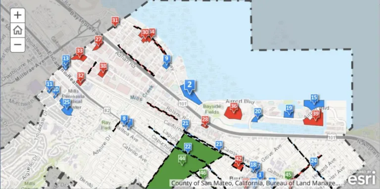
Current Burlingame Shoreline Development Projects, Interactive Map
red = under construction blue=planned
ENVIRONMENTAL IMPACT ANALYSIS AND MITIGATION CATEGORIES
Air Quality and Greenhouse Gas Emissions
The EIR needs to analyze the impacts of each of the various potential pollutants and specify mitigation actions where needed. An inventory of criteria pollutants must be provided for both construction and maintenance activities of any on-shore or off-shore levee/barrier systems in order to compare alternatives. Pollutants to be addressed include the following, which are regulated due to their adverse health effects:
- ground level ozone
- nitrogen oxides,
- particulate matter,
- carbon monoxide,
- sulfur oxides and
- lead.
The EIR should also address toxic air contaminants (TAC), a broad class of compounds known to have adverse health effects. Diesel exhaust is the predominant TAC in urban air.
Emission control strategies to reduce particulate emissions and nitrogen oxides must be identified and implemented in conjunction with the the Bay Area Air Quality Management District (BAAQMD) and the California Air Resources Board (CARB) guidelines which include both on-road and off-road equipment. Sensitive receptors to criteria pollutants and TACs must be identified and exposure estimated.
The impact of construction and maintenance activities on local roadways should be estimated with BAAQMD’s Roadway Screening Analysis Calculator to assess whether there is increased cancer risk for nearby receptors. Construction and maintenance activities should follow the BAAQMD’s best management practices to reduce particulate emissions especially PM2.5 and PM10 from equipment use and fugitive dust emissions. The use of electric equipment should be considered where practicable.
A greenhouse gas emissions inventory must also be performed for all construction and maintenance activities for shoreline and offshore levee/barrier systems in order to compare alternatives. Carbon dioxide and di-nitrogen oxide are byproducts of fossil fuel combustion including all gasoline-powered and diesel-fueled equipment and contribute to global warming.
Biological Resources
From the ecological perspective this Project spans a very large area and includes a substantial span of interconnected habitats utilized by an extraordinary number of animal and plant species. We are deeply concerned about the Conceptual Feasibility Report's analysis, which appears to overlook essential ecological conditions and the extensive impacts an offshore barrier is likely to impose. The report relies on a Biology Resources Constraints Analysis by Rincon Consultants Inc. (Rincon Report).7 Unfortunately, that analysis, constrained by the Project's design, was narrow in scope, time, and content, basically limited to one terrestrial survey and literature studies.8 The Conceptual Feasibility Report provided no estuarine studies or analysis of the lands that may lie inboard of a barrier wall. Nor did it address habitat-altering changes produced by an offshore barrier’s change to water conditions inboard of a barrier.
Key constraints of offshore barriers, particularly water quality, were identified, but inconsistently highlighted in the Rincon Report and not mentioned in the Conceptual Feasibility Report. Because the preferred alternative for this Project proposes an offshore barrier, such major omissions undermine the validity and credibility of the Project’s Conceptual Feasibility decisions.
Below we discuss these issues and others, asking that the Project fully identify and analyze substantial biological resource issues, avoid impacts, and recommend mitigation for significant impacts even if that means that no barrier should be built.
Water Quality Impacts on Biological Resources
Water quality was identified in the Rincon Report as a constraint for the offshore barrier alternative, but the report discusses only two potential positive impacts on biological resources: expansion of eelgrass habitats and an increase in filter-feeders. There is no discussion of the potential negative impacts of the alternative on water quality within the lagoon, which would have potentially major impacts on estuarine biota. This is a critical omission in the report. The EIR needs to include a detailed evaluation of the changes to the estuarine ecology that may occur with an offshore barrier. Additional discussion of the data needs for a thorough hydrology and water quality assessment for this alternative is provided below under Hydrology and Water Quality.
- Reduced or modified water circulation: Section 5.9 and Appendix I of the Conceptual Feasibility Report discuss an effort to model water circulation for two lagoon sizes and single or dispersed tidal gates. Creek inflows are not considered. While limited in scope, the model results indicate that the alternative will impact circulation within the lagoon, which will in turn affect the estuarine ecology that supports biological resources. Changes to circulation will also impact the ecology of creeks near the shoreline, even if those sites are excluded from the Project footprint. With tidal gate closures, reduced salinity due to creek and stormwater inputs could lead to wholesale changes to the shoreline ecology, for example replacement of salt marshes with tule beds. Higher turbidity and sedimentation rates might change the species present at all levels in the food web.
The EIR needs to collect current water quality data to establish a baseline for specific measures of water quality that will likely be impacted by changes to water circulation.
Important parameters to measure include, but are not limited to, the following:- Tidal and creek flows and velocities,
- Salinity and stratification,
- Turbidity,
- Sedimentation rates and patterns, and
- Temperature.
The EIR should use the baseline data and the final alternatives designs to evaluate the impacts of circulation changes on water quality and the resulting impacts to biological resources. The evaluation should include scenarios that encompass the range of durations of tidal gate closures and the range of freshwater flows entering the lagoon.
- Water quality-related outbreaks
Enclosed water bodies with poor circulation are susceptible to stratification, anoxia and elevated water temperature; conditions commonly associated with fish kills, algal blooms and avian disease. Climate change is increasing these incidents as water temperatures rise. Impacts can occur broadly or in pockets where circulation is poor. Schools of fish can end up trapped behind a barrier and die in low dissolved oxygen zones, producing emissions of noxious odors and toxic, volatile sulfides. Algal blooms can release toxins lethal to wildlife and dogs, and potentially toxic to humans. Infectious diseases such as H5N1 influenza (bird flu) are propagated when waterfowl congregate in enclosed ponds and lagoons. Disease transmission can be exacerbated by poor water quality. The EIR should analyze the potential for such outbreaks and their impact on biological resources.
- Water pollution
Sources of pollutants from the Millbrae/Burlingame shoreline to the Bay waters include creek outflows, overland runoff, stormwater drains, groundwater discharge, shoreline erosion, and airborne dust. While managing pollution from these sources is not in the Project scope except during construction, reduced tidal flushing can lead to increased concentrations of contaminants in the lagoon water and sediment, and into the biota. For some contaminants, biomagnification up the food chain could result in levels dangerous to humans or wildlife consuming fish from the lagoon. Reduced tidal circulation may trap trash within the lagoon (e.g., balloons, netting, fishing line), harming waterfowl and marine mammals by entrapment or ingesting items. The EIR should evaluate the impact of increased pollutant concentrations and debris on biological resources.
Ecology, Habitats and Wildlife
The NOP and its related, published documents provide inadequate baseline data and analysis to inform scoping comments. By limiting analysis to isolated areas located on and along the shoreline, the Rincon Report artificially misrepresents the biological complexity of this interrelated ecosystem of riparian, shoreline, and estuarine habitats. Furthermore, the Rincon Report indicates that “[n]o biological impacts were evaluated for impacts during this analysis.”9 As a result, the Conceptual Feasibility Study, which relies heavily on the Rincon Report, is severely inadequate. In addition to the actions recommended in the Rincon Report to better analyze feasibility constraints, the EIR must fill the data gap for baseline conditions in order to support a thorough evaluation of Project alternatives.
To be adequate for the Project, impact analysis in the EIR will require a complete and thorough biological assessment that addresses the topics below, does not depend on the limited scope of the Rincon Report, and includes all anticipated analysis needed to identify a Least Environmentally Damaging Practicable Alternative that will be accepted by regulators.
The following additional data collection and evaluation efforts should be conducted for the EIR.
- Field survey locations
Surveys must be performed throughout the Project area to enable assessment of Project impacts on connected inland habitats that lie outside the Project footprint. Pending alternatives selected for EIR review, connected areas could include the Burlingame and Sanchez lagoons, lower creek habitats, and planned restoration sites (e.g., Sphere project, Peninsula Crossing project near Airport Boulevard), San Francisco Airport’s shoreline marshes, Bay conditions outboard of a barrier wall and other sites.
- Field survey timing
Whether onshore, offshore, or below Bay waters, wildlife presence and habitat use varies by season. While Species of Special Concern must be identified, so must varieties of species that are dependent on habitats year-round or as migrants that currently exist within the Project footprint and outside the footprint and that may be impacted by the Project changes.
Field surveys in any habitats within the Project footprint must be completed for each particular habitat type seasonally. Seasonal surveys will identify year-round residents, overwintering waterfowl and seasonal migrants like the wide range of shorebirds that are seen in the thousands on the mudflats and marshes, protected under the International Migratory Bird Act. Likewise underwater surveys, possibly performed from boats, will identify seasonal variation in fish species. These surveys need to include habitats outside the Project footprint, inland or in the Bay, that will be impacted by Project changes such as water quality conditions.
- Natural communities
The Project needs to identify natural communities above and below the waterline. Natural community assessments will provide the monitoring baseline for potential impacts produced by implementation of the Project.
As bathymetric elevations vary substantially from west to east on the Bay’s edge in the proposed footprint, the natural communities will vary. Shallow or slightly above still water level in the west supports the most extensive tidal marshes from Baylands Park and the fringe marsh along the SFO boundary to the north and west. Heading east and by Mills Creek, the slope of the Bay increases nearshore and doing so produces substantial mudflat edged by vestigial natural beach extending to the bend at Airport Blvd. East from there, the water deepens further, still water levels continuously reaching shore, sufficient to support shoreline fishing activity. In deeper waters, eelgrass beds exist and will require Project surveys to map and assess the health of its habitat. Inland, in creeks and lagoons that altered water conditions will impact, fringe marshes of varied types need to be identified and condition noted.
- Special Status Species of Concern
For any Project, Special Status species must receive particular attention. Doing so requires analysis that is narrowed to use the best of local data and not get off track by focusing on state databases. An example: as Ridgway’s rail is unique to the Bay and Northern California shoreline, the responsible agencies and science partners have the best data about this rail. Uniquely, SFO has Ridgway’s rail monitoring data that is directly applicable to this Project’s footprint. Further citizen science provides years of observations on this shoreline of the same bird.
For local Special Status species data, we strongly recommend that the biological assessment include informally consulting with the wildlife agencies (US Fish & Wildlife Services, California Department of Fish & Wildlife, National Marine Fisheries Service), established science organizations (Point Blue Conservation Science, San Francisco Bay Bird Observatory), and citizen resources like E-Bird.
Hazards and Hazardous Materials
The Hazardous Materials Constraints Analysis Final Report10 identified a large number of sites that may contain hazardous materials, located within 1000 feet of the footprint of each Project alternative. Some of these sites are known to have hazardous chemicals present in soil, soil vapor or groundwater, including volatile organic compounds (VOCs), per- and poly-fluorinated alkyl hydrocarbons (PFAS), and gasoline components and additives (e.g., MTBE).
Although the report properly evaluates constraints associated with disturbing contaminated soils and sediments during construction, there is no discussion of the impacts of the alternatives on the Bay environment, recreation, and public health. The EIR needs to evaluate how each alternative will impact releases of hazardous chemicals from shoreline sites to groundwater and to the Bay. In particular, construction of an offshore barrier with tidal gates will have the effect of reducing tidal flushing, potentially leading to increases in the concentration of pollutants in the lagoon water and sediment. The EIR should evaluate the environmental fate and transport of contaminants entering the lagoon from stormwater, creek flows, overland runoff, and the tidal action of rising groundwater on shoreline hazardous material sites and the Burlingame landfill. The evaluation should address the potential for the chemicals to bioconcentrate or bioaccumulate in benthic organisms, fish, birds and mammals using the lagoon.
Known sites with hazardous chemicals that may be of concern due to their proximity to the Bayshore (located between Highway 101 and the Bay) include but are not limited to the following.
- Burlingame landfill As discussed in the Hazardous Materials Constraints Analysis report, monitoring wells at this closed landfill have been reported to contain low levels of PFAS. A tentative order from the California Water Board11 would expand the water quality monitoring requirements for this site and require additional protective measures for borings or pile driving through the cap into the underlying groundwater. The EIR should evaluate the impact of this order on each proposed alternative.
- Northern corner of Airport Boulevard and Old Bayshore Highway Elevated concentrations of gasoline-related contaminants (e.g., benzene, MTBE) were present in shallow groundwater at this location the last time the site was sampled, in 2010.12 Although this site is listed as closed in Geotracker, there may still be contaminants present at levels that could be of concern for migration to the Bay.
- 370 Lang Road Two closed sites are listed in Geotracker at this location. The monitoring wells were last sampled in 201013 and at that time contained gasoline-related contaminants above cleanup levels. These sites are not listed in the Hazardous Materials Constraints Analysis report, which should extend the site lists and map to the southern end of the Project area.
Depending on the alternative selected, it may be necessary to evaluate sites further inland that are expected to be impacted by rising groundwater. There are several leaking underground storage tank (LUST) sites landward of Highway 101 that have very high levels of gasoline- related contaminants in the shallow groundwater.
The Burlingame and Millbrae Wastewater Treatment facilities emergency outfalls enter San Francisco Bay within the Project location. In October 2021, the Burlingame facility discharged 865,000 gallons of fully treated wastewater to the Bay that could not be accommodated in the North Bayside System Unit pipeline.14 The plant also lost power and experienced a failure of the stormwater pumping system. Release of untreated wastewater, which could occur with an extended outage or equipment failure, would pose hazards to human health and the environment. The EIR should evaluate how the project alternatives would accommodate emergency response in this type of emergency.
Hydrology and Water Quality
Water Quality
The Rincon report and Feasibility Study fail to consider likely impacts of the offshore barrier alternative on lagoon water quality. The impact of physical and chemical processes on offshore biological resources, including but not limited to those listed below, should be evaluated in the EIR. Scenarios evaluated should cover the full range of anticipated duration of daily tidal gate closures (i.e., high tide only to 24-hour/day closure). If the impacts to biological resources are found to be significant and unavoidable, the EIR should identify means to avoid these hazards or, if not possible, the most effective mitigation measures.
- Changes in salinity
Changes in salinity will occur with reduced tidal cycling and with impoundment of stream flows and stormwater discharge. The EIR should evaluate the future range of salinity expected within the lagoon and the resulting impact on biological resources.
- Stratification and anoxia
With extensive closure of the tidal gates, there will be less mixing, leading to likely formation of saltwater and freshwater layers in the lagoon and anoxic or low oxygen conditions in the denser salt water layer. An anoxic layer would negatively impact biological resources. It would also create favorable conditions for formation of toxic hydrogen sulfide, which would directly impact fish and birds as well as creating noxious odors and a potential health hazard for nearby human populations.
- Eutrophication
Closure of tidal gates for extended periods will increase the temperature of the lagoon waters, particularly with higher ambient temperatures due to climate change. Nutrients from stormwater runoff and streamflows would receive less dilution from tidal flushing. Along with the higher temperatures, this will create favorable conditions for eutrophication. The result would be the death of fish and other aquatic organisms through lack of oxygen, and more frequent algal blooms that could harm fish, birds and other wildlife, as well as posing a health hazard to humans.
- Sedimentation
Closure of tidal gates will reduce currents in the enclosed area, leading to greater deposition within the lagoon of sediment from creek outflows, stormwater, and overland runoff. The EIR should evaluate the impact of sediment deposition on water quality, biological resources, and aesthetics. In addition, the EIR should evaluate the requirements to maintain the lagoon as a water body as it becomes shallower over time due to sedimentation.
- Accumulation of pollutants
Closure of tidal gates for extended periods will reduce or eliminate dilution of pollutants within the lagoon. Pollutants are currently discharged into shore waters via stormwater discharge, overland runoff, and through tidal action and outflow of shallow groundwater beneath hazardous material sites along the shoreline. Contaminants of emerging concern (CECs), including pharmaceuticals and personal care products (PPCPs), are increasingly being detected at low levels in surface water, and there is scientific evidence and growing concern that these compounds may have an impact on aquatic life.15 Without tidal flushing, pollutants will be concentrated in the lagoon waters and sediments, may bioaccumulate or bioconcentrate in benthic organisms and fish, and have adverse impacts on birds and other wildlife that feed on those organisms.
- Floating debris
Extreme rain events such as occurred in January 2023 produce large quantities of floating wood and other debris in creek outflows. Such storms are predicted to become more frequent with climate change. With reduced or absent tidal action, this debris is likely to settle to the lagoon floor and decompose, contributing to formation of an anoxic layer. Manmade trash such as plastic bags and food containers will also enter the lagoon with creek flows. The EIR should evaluate the impact of natural and man-made debris on water quality and biological resources within the lagoon, as well as impacts on the operation of the tidal gates.
Groundwater Rise
The NOP and supporting documents fail to consider the impact of future groundwater rise on the feasibility of the onshore barrier alternative and the impact of rising groundwater on land use and biological resources within the Project footprint. Studies have shown that the depth to groundwater along a shoreline typically decreases as sea level rises, due to salt water moving inland beneath shallow freshwater aquifers. Flooding from groundwater emerging at the land surface is projected to be prevalent in the future. The EIR should address the impacts of groundwater flooding for the onshore barrier alternative, as pumping may be required to remove the water.
Groundwater rise and saline intrusion can have adverse impacts on infrastructure along the shoreline, including weakening of concrete building foundations and corrosion of buried utilities. These impacts often occur well before seawater inundation becomes a problem.16 Rising groundwater can also mobilize contaminants in soils containing hazardous materials, carrying the contaminants to the ground surface or, by groundwater flow, creek flow, and tidal action, into the Bay. Combined with lagoon effects from an offshore barrier, contamination via rising groundwater could exacerbate a range of impacts on water quality (see above). The EIR should evaluate whether Project alternatives will modify the extent of these impacts to land use and to onshore and offshore biological resources.
Several research groups have used numerical modeling techniques to estimate the impact of sea level rise on shallow groundwater along the San Francisco Bayshore.
- Plane et al. 201917 used data from monitoring well groundwater elevation and measurements and tidal ranges to model San Francisco Bay shoreline groundwater depths at highest high tide. In the Project area, groundwater between the Bay and Highway 101 is already quite shallow. Minimum depths to groundwater range from < 1 meter to 3 meters below ground surface (bgs). The model results indicate that some areas near the shoreline may already experience emergent groundwater (black areas in figure below). Groundwater was also modeled for a one-meter sea level rise, finding that large areas of the shoreline would be inundated with groundwater, beyond the areas experiencing flooding from the Bay.
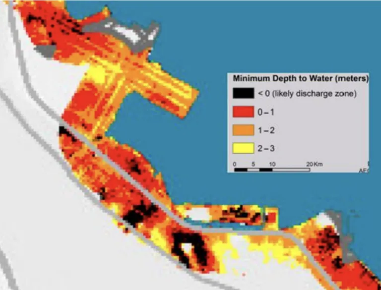
Hydrologic model of minimum depth to groundwater in Project area
(modified from Plane et al., 2019)
- Befus et al., 202018 determined that saltwater intrusion due to sea level rise is constrained by topography in most of the SF Bay Area; i.e. the rapid rise in ground elevation away from the Bay forces rising fresh groundwater to emerge as flooding. The result is that the salt water wedge from rising sea levels will not move as far inland as predicted by a simple hydrologic model.
Neither of these modeling studies included a scenario with shoreline levees or an offshore barrier. Levees and shoreline barriers are typically ineffective at stopping groundwater rise, as the sea water can pass beneath the barrier. Given the complexity of the Project area shoreline geometry, currents and tides, and the patchwork of sand, bay mud and artificial fill that comprises the shoreline, it is critical that the EIR evaluate the impact of each selected alternative on depths to groundwater along the shoreline, and the resulting effects on public health, biological resources, recreation (e.g., fishing), and public infrastructure.
Land Use and Planning
As noted in the Project Alternatives section, above, the EIR should consider a shoreline alternative that incorporates nature-based solutions to the greatest extent practicable. We urge you to consider an Adaptation Pathways19 20 approach for such an alternative that allows for flexibility, staggered investment, and feedback and engagement mechanisms to inform whether to adjust strategy to take advantage of or respond to new conditions.
Growth Inducing Impacts
Section 15126.2(e) of the State CEQA Guidelines requires an EIR to “discuss the ways” a project could be growth inducing and to “discuss the characteristics of some projects that may encourage...activities that could significantly affect the environment....”21 The Guidelines also state that an EIR should discuss the ways in which the Project could foster economic or population growth or construction of additional housing, either directly or indirectly, in the surrounding environment. To address this issue, potential growth inducing effects of the Project should be examined through EIR analysis of the following questions.
- Would the Project remove obstacles to growth through the construction of these major infrastructure facilities that do not presently exist in the Project area, or through possible changes in existing regulations pertaining to land development?
- Would this Project result in the need to expand public utilities or services to maintain desired levels of service for the induced growth?
- Would this Project foster population growth (e.g., construction of additional housing), either directly or indirectly through job growth?
- Would this Project encourage or facilitate economic effects that could result in other activities that could significantly affect the environment?
Recreation and Public Safety
The offshore barrier alternative raises new challenges related to recreation in the Project area, from increased human intrusion into relatively isolated habitats, to safety and maintenance logistics and liability, to impacts on existing fishing and water sport pursuits.
Human Intrusion
It is unclear from the NOP whether the “pedestrian trail” being considered as part of the offshore barrier would be an extension of the San Francisco Bay Trail. Current uses of the Bay Trail, where it exists, include walking, running, bird watching, access to fishing sites, and other recreational uses. The EIR should analyze the impacts of newly introducing the variety and volume of Bay Trail users (and any artificial lighting of the facility) to Bay habitat that currently has little exposure to human activity.
Ownership, Upkeep, and Safety
The proposal to construct a trail atop a 2.65-mile barrier raises critical questions regarding ownership, upkeep, and user safety. As the San Francisco Bay Trail typically does not own the trails designated as "Bay Trail," clarity is needed on ownership, responsibility for maintenance, and jurisdiction for emergency response. The EIR should analyze potential scenarios, such as medical emergencies away from the shoreline, and identify solutions to ensure public safety. Additionally, it must address legal liabilities if emergency response is hindered due to trail design constraints.
Pier/Shoreline Fishing
The current popularity of shoreline fishing, particularly at the Project's easterly end, is characterized by diverse participants from various economic backgrounds, ethnicities, and language groups. The proposal for a barrier may significantly alter circulation, water quality, and the availability of fish species. The EIR should comprehensively assess the impact on fishing conditions, including changes to easy access and the socio-economic demographics of the fishing community. It is crucial to ensure that the proposed project does not adversely affect the equality of access to free recreational opportunities.
Water Sports
The Project area is a popular destination for wind- and sail-board enthusiasts. The EIR should evaluate the impact of an offshore barrier on water sport access to the Bay as well as changes to wind patterns, water conditions, and safety implications for recreational users. Thank you for the opportunity to submit scoping comments for the Millbrae and Burlingame Shoreline Area Protection and Enhancement Project EIR. We look forward to continued engagement with OneShoreline as the Project concept further evolves and
proceeds through the CEQA environmental review process.
Sincerely,
Jennifer Chang Hetterly
Bay Alive Coordinator
Sierra Club Loma Prieta Chapter
Cc James Eggers, Executive Director, Sierra Club Loma Prieta
Gladwyn d’Souza, Conservation Chair, Sierra Club Loma Prieta
1 See for example: https://www.sierraclub.org/sf-bay-alive/sea-level-rise-webinar-why-we-need-nature-based-adaptation
2 Appendix D, Schaaf & Wheeler, Coastal Hazards Analysis, September 2023; Section 4.3.1, pp 4-9 to 4-11.
3 San Francisco Estuary Institute and SPUR 2019, San Francisco Bay Shoreline Adaptation Atlas, 170.
4 San Francisco Estuary Institute and SPUR 2019, San Francisco Bay Shoreline Adaptation Atlas, 170.
5 Rincon Consultants, Biological Resource Constraints Analysis, Prepared for the Project, April 2023; Figure 22, p. 69
6 ORDER No. R2-2023-xxxx. UPDATED WASTE DISCHARGE REQUIREMENTS and RESCISSION OF ORDER Nos. 82-55, 95-130, and R2-2007-0039 for: CITY OF BURLINGAME SANITARY SOLID WASTE DISPOSAL SITE, BURLINGAME, SAN MATEO COUNTY, May, 2023
7 Rincon Consultants, Inc., Biology Resources Constraints Analysis, Millbrae and Burlingame Shoreline Area Protection and Enhancement Project
8 Ibid, Executive Summary, p.1, paragraph 1, April 2023
9 Ibid. Rincon Consultants, Biological Constraints Report, Executive Summary, p.1, April 2023
10 Millbrae and Burlingame Shoreline Area Protection and Enhancement Project, Hazardous Materials Constraints Analysis Final Report. Rincon Consultants, Inc. April 2023
11 ORDER No. R2-2023-xxxx. UPDATED WASTE DISCHARGE REQUIREMENTS and RESCISSION OF ORDER Nos. 82-55, 95-130, and R2-2007-0039 for: CITY OF BURLINGAME SANITARY SOLID WASTE DISPOSAL SITE, BURLINGAME, SAN MATEO COUNTY, May, 2023
12 California Waterboards, Groundwater Information System (GAMA Groundwater) map, accessed November 15, 2021.
13 Ibid
14 STATE OF CALIFORNIA REGIONAL WATER QUALITY CONTROL BOARD SAN FRANCISCO BAY REGION DATE: January 12, 2022 Update on Sewage Spills Caused by October 24 and 25 Atmospheric River
15 Front. Earth Sci., 13 September 2023 Sec. Hydrospher,Volume 11 - 2023 “There are many CECs and PPCPs that act as so-called endocrine disruptors (EDCs). EDCs are compounds that alter the normal functions of hormones resulting in a variety of health effects. EDCs can alter hormone levels leading to reproductive effects in aquatic organisms...”
16 May CL, Mohan A, Plane E, Ramirez-Lopez D, Mak M, Luchinsky L, Hale T, Hill K. 2022. Shallow Groundwater Response to Sea-Level Rise: Alameda, Marin, San Francisco, and San Mateo Counties. Prepared by Pathways Climate Institute and San Francisco Estuary Institute.
17 Plane, E., Hill, K. and C. May. A Rapid Assessment Method to Identify Potential Groundwater Flooding Hotspots as Sea Levels Rise in Coastal Cities. Water. 2019.
18 Befus, K.M. et al., Increasing threat of coastal groundwater hazards from sea-level rise in California. Nature Climate Change, volume 10, pages 946–952 (2020)
19 Adaptation pathways: A review of approaches and a learning framework, Environmental Science and Policy, 2016. Adaptation pathways have experienced growing popularity as a decision-focussed approach in climate adaptation research and planning. .... They have become recognised as sequences of actions, which can be implemented progressively, depending on how the future unfolds and the development of knowledge. Pathways approaches orientate around performance-thresholds, multiple- stakeholders or transformation
20 Annals of the New York Academy of SciencesVolume 1427, Issue 1: Pathways to Resilience: Adapting to Sea Level Rise in Los Angeles Sep 2018 PagesI-IV, 1-90 Case studies of adaptation pathways
21 Cal. Code Regs. Tit. 14, Section 15126.2 Consideration and Discussion of Significant Environmental Impacts