April 12, 2024
Public Works Department
Environmental Initiatives
PO Box 381
Redwood City, CA 94064-0391
Transmitted via email: SeaLevelRiseStudy@redwoodcity.org
Re: Redwood City Sea Level Rise Vulnerability Assessment
The Sierra Club Loma Prieta Chapter’s Bay Alive Campaign welcomes this opportunity to provide comments on the Redwood City Sea Level Rise Vulnerability Assessment (Report). We do so on behalf of tens of thousands of local Sierra Club supporters who share our commitment to protect the health of our communities, our wildlife and our Earth by promoting living shorelines, healthy waters, and just, equitable solutions to sea level rise in the San Francisco Bay Area.
| Bay Alive Campaign advocates for the multi-layered benefits of natural and nature-based adaptation to sea level rise |
Our Bay Alive Campaign advocates for the multi-layered benefits of natural and nature-based adaptation to sea level rise, for regional coordination, and for equitable strategies to build community resilience. We contribute to plans, guidance, and actions under consideration at local, regional and State levels. We serve as members of both the Bay Conservation and Development Commission’s (BCDC) Advisory Working Group and Implementation Group for the new guidelines being developed for the Regional Shoreline Adaptation Plan (RSAP). We welcome this opportunity to contribute our insights and look forward to communicating with the City of Redwood City as well as One Shoreline throughout the study phases and subsequent project phases. |
| Bay Alive is concerned at the absence of nature-based adaptation solutions in the Report |
Redwood City’s Sea Level Rise webpage describes the impact of sea level rise on the City, which provides the rationale for developing the Report: The ultimate goal of the assessment is to develop sea level rise adaptation strategies, to advance flood protection, and to protect ecosystems and the built environment along the Bay. (Emphasis added)
Therefore, we are concerned at the cursory references to ecosystems and natural infrastructure in the Report, which misses the opportunity to include these strategies as an integral part of the city’s strategy for resilience to climate change and sea level rise (SLR). The adaptation strategies described in the Report for the shoreline of Redwood City lack information on natural infrastructure options including descriptions of ecosystems and ecoservices as well as their inclusion as new adaptation strategies, or protection and enhancement of existing natural ecosystem assets1 |
| SB272 passed in 2023 It requires all local governments, by 2034, to have a SLR plan that is approved by BCDC, based on guidelines incorporating the Bay Adapt Joint Platform’s six guiding principles |
Senate Bill 2722 3 requires all local governments to prepare SLR adaptation plans by 2034. The law also requires all the plans to be approved by BCDC, using design guidelines based on the Bay Adapt Joint Venture’s six guiding principles4. These include “Support Socially Vulnerable Communities” and “Put Nature First Whenever Possible” as the top two priorities. BCDC’s guidelines are required to be completed by the end of 2024 and cities that receive BCDC approval for their SLR plans, based on meeting the guidelines, would receive priority for grant funding. |
| Historical perspective San Mateo County’s Sustainability Department worked with Stanford and SFEI to explore and evaluate a menu of nature-based SLR strategies for the County’s entire Bay shoreline |
In 2018-2019, the San Mateo County Sustainability Department proactively conducted a large, participatory, science-based project to investigate, document and promote appropriate nature-based adaptation solutions for the County’s shoreline.5 The county worked with Stanford’s Natural Capital Project (NatCap) and the San Francisco Estuary Institute (SFEI) to explore and evaluate a menu of nature-based SLR strategies for the County’s Bay shoreline. The partnership included County staff, as well as numerous government and NGO stakeholders engaged by the County. The Adaptation Atlas6 served as a valuable reference and is considered a starting point for appropriate nature-based solutions within the Bay Area. The Atlas identifies “Operational Landscape Units” (OLUs) along the Bay shoreline with shared geophysical and habitat characteristics suited for particular sets of adaptation strategies. This county project as well as recent research underscores the efficacy of nature-based solutions in safeguarding coastlines while providing a myriad of necessary ecosystem services.7 Further studies will be needed to develop appropriate nature-based strategies for each portion of the reaches of Redwood City, based on a closer study of the site-specific shoreline conditions. |
| Redwood City’s Flooding Vulnerability The Report needs to include discussion of the full range of risks associated with flooding from SLR including simultaneous storm events as well as rising groundwater. |
In San Mateo County, Redwood City has the greatest vulnerability to flooding, and this will be exacerbated by a combination of SLR, storm water and emergent ground water combined. The County project, in the article by SFEI and Stanford’s Natural Capital Project, emphasizes this aspect in the graph below that shows the percentage of the OLU that would be inundated. 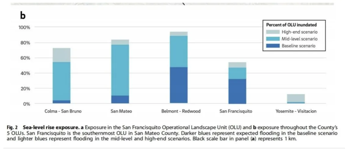
In the Report, adaptation strategies focus primarily on the threat of flooding from the Bay and secondarily on vulnerabilities in the stormwater drainage system, sea-level rise effects on marshes, and other factors.
The Report makes clear that Redwood City’s vulnerability is extensive and also extends west/south of 101, into a portion of the Downtown area, as well as some vulnerable residential areas. This residential area is also exposed to fluvial flooding from Cordilleras Creek, per the Report. This discussion is important in order for the City to be able to plan and to take advantage of strategies related to flooding resilience that simultaneously address multiple objectives - such as ecoservices, habitat, recreation, green stormwater infrastructure, etc. |
|
Applying Nature-Based Solutions to Redwood City
Legend for the Map |
While we find the analyses of existing conditions and SLR projections in the Vulnerability Assessment to be thorough and well explained, the Adaptation Strategies section, which includes how Redwood City can best adapt, provides little new information and leans largely on augmenting existing or adding new “gray” infrastructure. Adaptation strategies focus primarily on the threat of flooding from the Bay and secondarily on vulnerabilities in the stormwater drainage system, sea-level rise effects on marshes, and other factors on a reach-by-reach basis. Accordingly, the primary adaptation measure for all reaches is to raise the low-lying parts of the shoreline with a levee (if space permits) or floodwall.
Further studies will be needed to develop appropriate strategies for each portion of the reaches of Redwood City, based on a closer study of the site-specific shoreline conditions. This should be done using a science-based organization such as San Francisco Estuary Institute8 that is experienced in Bay ecology, the myriad ecoservices of living shorelines and natural flood protection combined with other potential benefits, and possibly including recreation opportunities. Below is the map of the area showing Foster City and Redwood City and the potential ecosystem services that could be achieved through OLU-focused nature-based strategies. 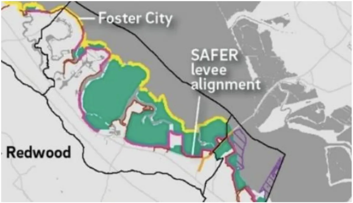
|
|
Natural infrastructure is important because it provides multiple benefits and invaluable ecosystem services |
Natural infrastructure typically offers 'no-regret” or “low-regret' options due to their incremental implementation and monitoring requirements, potentially yielding lower upfront costs and greater flexibility over time. Moreover, they provide invaluable ecosystem services that clean pollutants and toxics out of stormwater and treated-wastewater, safeguard important wildlife habitats, create new and restored habitats, sequester carbon, and temper our weather while simultaneously reducing our communities’ vulnerability to flooding and erosion and enhancing resilience. 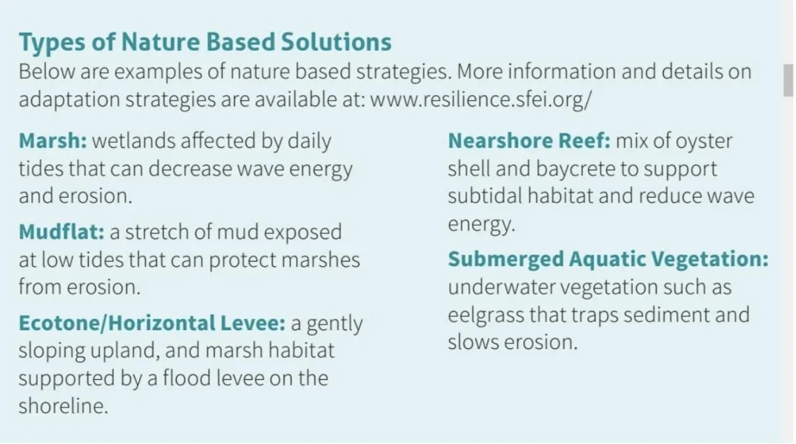
|
|
The Report needs to include nature-based adaptation strategies Regional SLR guidelines will require that all local governments cooperate, in their sea level rise adaptation planning, to incorporate an appropriate share of the natural infrastructure restoration needed for our shared asset, a healthy vibrant Bay |
The Report’s Adaptation Strategies section leans heavily on improving existing “gray” infrastructure. In regards to consideration of natural infrastructure for SLR, for Bay health and for ecosystem survival, with the exception of suggesting an Ecotone levee at the Cargill salt ponds in Reach 4, the Report basically suggests the following for all the reaches: Maintaining these marshes through monitoring and restoration may help them continue to provide substantial benefits even as sea level continues to rise.
In contrast, the San Mateo County Sustainability Department’s project suggests substantial potential for nature-based solutions to provide multiple benefits. The map included above shows Ecotone - style levees in Reaches 1 and 2 and Marsh augmentation in Reaches 1 and 4 (Cargill salt ponds). The project also suggests inclusion of “beaches” along the outer bay edge of the marshes to mitigate wave-runup and prevent marsh erosion from increased wave action (see map above), though that may lie in another jurisdiction such as the Don Edwards National Wildlife Refuge. From the County project paper 9: Our models suggest that a future shoreline with existing and planned restoration projects will feature five times more marsh (which is habitat for, among other things, the endangered Ridgway’s Rail (Rallus obseletus)), and deliver five times the carbon sequestration and six times the stormwater pollution reduction of an engineered shoreline. Such a future will also provide an additional 50 ha of beach. A future shoreline that incorporates additional feasible nature-based solutions could provide up to six times the marsh area, eight times the stormwater pollution reduction, and six times the carbon sequestration of an engineered baseline. Furthermore, this scenario provides an additional 170 ha of beach.
Regional SLR planning will require that all local governments cooperate, in their sea level rise planning, to incorporate an appropriate share of the natural infrastructure needed to maintain and improve the health of our shared natural asset - the Bay’s living shorelines. Optimally, these vital ecoservices that the cities SLR strategies will provide will augment these shared natural assets to achieve the goal of 125,000 acres of wetlands and marshes as well as additional transition and migration space as sea levels rise.10 Presently, a pivotal opportunity exists to put “Nature First Whenever Possible” for the four reaches, integrating habitat protection, enhancement and restoration into planning for SLR adaptation. Where natural infrastructure cannot be considered, it should be clearly indicated why that would be the case as the multiple benefits would need to be given up. |
|
Adaptation Pathways |
We appreciate the Report suggesting the City consider adaptation pathways that include a combination of short-term strategies and long-term goals. Short-term measures are anticipated to be completed in the next 5-10 years and could be interim efforts that accommodate less than 3.5 ft of sea-level rise. Long-term measures are those that would provide FEMA accreditation with 3.5 ft sea-level rise, which should be sufficient for sea-level rise projected to be likely through 2100
It is important that adaptation pathways be developed as a realistic option so that the City builds in flexibility in the face of an uncertain future. Adaptation pathways, with short-term goals, potentially yield lower upfront costs due to their incremental implementation and monitoring requirements, and greater flexibility over time. We endorse the Report’s advice that the City’s strategies also need to include management processes for monitoring the progress of sea level rise, groundwater rise, and flooding experiences of storm events in the project period. |
|
Ordinances as part of adaptation strategies |
We also believe that the Report’s adaptation strategies need to include discussion on ordinances and land use policy. It needs to address developing ordinances that clearly lay out responsibilities that owners assume when developing in areas where flooding and groundwater are present near the surface and where infrastructure is subject to intermittent flooding or high ground water. In addition, the maintenance and deterioration of city-supported surface and underground infrastructure needs to be considered in areas facing both SLR and groundwater rise. Underground infrastructure located in salt water or brackish water will deteriorate much faster than in normal drier conditions. New roadbeds, if provided, will need to be raised to a higher elevation along with raised utilities. Limiting investment of city capital for maintaining existing or for installing new infrastructure to support development in vulnerable areas needs to be part of an overall strategy to address City budget resilience in the face of SLR. |
We include the following unique adaptation opportunities
- Some Special Nature - Based Adaptation Opportunities
- Reserve Migration Space for Tidal Wetlands
Marsh migration space is a high priority and is needed all around the Bay.11 The study area includes potential areas for upland migration space for marshes. These areas should be earmarked for conservation and considered for “Priority Conservation Area” (PCA) status. Plan Bay Area 2050’s “PCA Refresh” program, currently in final draft, is revising it’s PCA definitions to include the shoreline of San Francisco Bay for tidal marsh and wetland protection, restoration and migration.
- Enhance New Marsh Opportunities at Creek Mouths
Enhancing connections between creeks and their floodplains in order to increase freshwater and sediment flow into baylands is essential for the much-needed increase of tidal marsh and wetlands.12 All the creeks should be studied for enhancement and restoration of their alluvial fans with sediment brought downstream to the creek mouths. In addition to mitigating storm surge, we reiterate that new marshes are needed to provide critical ecosystem services including much needed stormwater nutrient reduction, carbon sequestration as well as nurseries for fish and hundreds of other creatures in the food chain.
More new marsh areas are especially critical as they will also provide much needed increased habitat, with a focus on the endangered Ridgway's Rail. Because Ridgway's Rail habitat is restricted almost entirely to the marshes of the San Francisco Bay, it is considered a good umbrella species for other elements of marsh-dependent biodiversity.13
- Consider using Flooding/ Resilience Overlay Zones for SLR
Hard engineering has traditionally been employed to protect communities in shoreline low lying communities, but as this alternative becomes less sustainable and more costly, flood control managers around the world are increasingly turning to land use planning strategies, such as setback zones or resilience zones to allow for transformation of the shoreline.
Burlingame is the first city in the Bay Area to pass a SLR ordinance requiring new development to be resilient to SLR and includes a 100’ setback “buffer zone” from the bay shoreline in order to provide space for resilience strategies.14 Currently, OneShoreline, San Mateo County’s Flood and SLR Resilience District, is in the process of preparing SLR Planning Policy Guidelines15, for use by all cities in the County, that include setbacks for SLR resilience for all new construction.
- Include Ecotone Levees around the Redwood Shores Wastewater Treatment Plant
The San Francisco Bay Regional Water Quality Control Board is working towards new guidelines16 that will require all the wastewater treatment plants around the bay (37 plants) to remove 40% more nitrogen and other pollutants before discharging treated wastewater into the Bay. This is required in order to protect Bay water from the damaging algae blooms experienced in the last two years.
Using a nature-based solution such as “Ecotone” Levees is one effective approach to “polish” treated sewer water, and studies show this can remove as much as 97% of nitrate and other pollutants.17 All the levees around the Silicon Valley Clean Water (wastewater treatment) plant should be Ecotone/Horizontal levees to maximize treatment facilities for wastewater and facilitate reducing nitrogen and other pollutants before discharging treated wastewater into the Bay.
An Ecotone levee needs setback space along the shoreline to allow marsh migration upslope over time as they have a very gentle slope on the Bay side. Ecotone levee slopes vary between 1:20 (maximum slope) and 1:30.
Ecotone levees and wetlands migration space are needed wherever feasible along the shoreline. However, levees should not be built on wetland areas to avoid destroying valuable habitat. In addition, levees should be built on firm soil (not soft Bay mud). A levee built on unstable bay mud is susceptible to subsidence over time, requiring levees to be built higher and wider. This results in higher costs and more space required for the levee structure in order to spread the weight over a wider footprint. A levee built on bay mud has a higher probability of damage due to liquefaction of bay mud during seismic events.
- Reserve Migration Space for Tidal Wetlands
- Stormwater Retention Areas
Most of the study area is slated to be safeguarded by proposed levees and is low-lying and, as noted in the Report, these areas are already subject to stormwater pumping for flood water control, and future groundwater rise, channeling water that ultimately flows into the Bay. As sea levels rise and groundwater rises, it is not clear that pumps will be able to operate at some peak high water times. Therefore, significant retention areas may need to be included in all reaches of the project. Retention areas can be space that is temporarily used for retention and otherwise available for recreation or other non-critical uses. This issue should be studied further.
- Address Potential Mobilization of Contaminants by Groundwater Rise (GWR) 18
The Report recognizes the potential for SLR to lead to emergent groundwater and flooding, but does not discuss the potential for shallow groundwater rise to mobilize soil- borne contaminants. The Report needs to identify all significant sites within the project boundaries, discuss the interactions between this project and other public and private efforts to remediate the sites, and the potential impacts on the feasibility and cost of onshore alternatives. For example, pumping to mitigate groundwater flooding will cause contaminant plumes in shallow groundwater to migrate to the well, which would require groundwater treatment facilities.
A cursory review of California Water Board’s Geotracker19 map shows numerous toxics sites and a former municipal waste landfill within the blue, orange and red-shaded areas in Figure 4 of the Report, corresponding to areas affected by SLR or emergent groundwater with 1-foot, 3-foot and 6-foot of SLR, respectively. Many of these sites were leaking underground storage tanks that have undergone cleanup and closure. However, there are also many sites with ongoing remediation and groundwater monitoring, or that have deed restrictions against disturbing the subsurface (See Table 1 below). Contaminants present at these open sites include chlorinated solvents, insecticides, PCBs, arsenic, metals, petroleum hydrocarbons, and ammonia. Rising water tables could bring these contaminants to the surface. The Report should include a discussion of the vulnerability of the community and possible mitigations to protect communities and the Bay from exposure to legacy pollutants.
Table 1: Contaminated Sites found in Geotracker
| Reach | Reach Description | Open Sites Bayside of Hwy 101 | Open Sites Inland of Hwy 101 |
| 1 | Redwood Shores shoreline from Marine Parkway to Nob Hill Pond | Sanitary pumping station. Former Westport landfill (ammonia, methane). | 15 open remediation or long-term management sites containing chlorinated solvents, PCBs, petroleum |
| 2 | Central shoreline from Pulgas Creek, sloughs behind Bair Island, and western shore of Redwood Creek below Bradford Street | One open remediation or long-term management site( PCBs) | 9 open remediation or long-term management sites containing chlorinated solvents, PCBs, petroleum |
| 3 | Central shoreline from Pulgas Creek, sloughs behind Bair Island, and western shore of Redwood Creek below Bradford Street | Eastern shore of Redwood Creek and western shore of Seaport Peninsula Port of Redwood City RCRA cleanup (petroleum), VOCs (site of new jail) petroleum hydrocarbons, asbestos-containing material. One site adjacent to Smith Slough (505 E. Bayshore) with PCB contamination of soils and sediments | 3 open remediation or long-term management sites containing chlorinated solvents, asphalt, petroleum |
| 4 | Interior shoreline between Cargill salt ponds and Friendly Acres to the south and Seaport Blvd. to the west | 1903 E Bayshore Road, In 1988, illegal dumping of toxic dirt from Hunter’s Point shipyard containing hazardous levels of metals, Never remediated, cleanup inaction as of 2010 | 4 open remediation or long-term management sites containing PCBs, metals, copper, lead, total petroleum hydrocarbons (TPH) |
Although many of the open sites identified in Table 1 are inland of Highway 101, we noted that at least three sites may be within the footprint of a future shoreline levee:
- At 505 E. Bayshore Road in Reach 3, soils and wetland sediments are contaminated with PCBs on a parcel adjacent to Smith Slough.20
- At 1903 E Bayshore Road in Reach 4, between 500 and 600 truckloads of toxic dirt from Hunter’s Point Naval Shipyard were illegally dumped in 1988 in a wetland parcel owned by the City of Redwood City.21 Soil analysis found dirt to be contaminated with hazardous levels of lead, arsenic, and copper. Although the site is listed as undergoing site investigation, there has been no regulatory activity since 2010.
- The former Westport Landfill is located at the site of the proposed Redwood Life development adjacent to Belmont Slough. The owners of this property completed and received RWQCB approval of a long-term flood protection plan.22 The plan specifies measures to address future emergent groundwater vulnerabilities to existing remediation infrastructure such as leachate collection systems and manholes. The Report does not address the potential for toxics mobilization. The SLR Vulnerability Study needs to evaluate whether the adaptation measures proposed in the Westport plan are consistent with future shoreline protection measures.
Rising groundwater can cause a myriad of other issues besides mobilizing toxins in solids and sediments. Rising groundwater can damage buried infrastructure, roadway subgrades, and building foundations in addition to increasing liquefaction risk and causing construction challenges.23 The Report should take these processes into consideration in evaluating vulnerability to SLR.
- Align with BCDC’s Regional Shoreline Adaptation Project (RSAP)
Please note that the Bay Conservation and Development Commission (BCDC) is currently developing their Regional Shoreline Adaptation Plan guidelines and, as noted earlier, plans to complete these guidelines by the end of December 2024. These guidelines will dictate the requirements for adaptation plans for all bayshore communities and require these plans to be submitted to BCDC for approval by having met the guidelines. Cities that get approved have the incentive of receiving priority for funding grants. Consequently, it is imperative that adaptation of the shoreline of Redwood City for SLR be consistent with these guidelines and its goals.
We look forward to continuing an ongoing productive exchange of ideas with the City of Redwood City on future shoreline projects.
Sincerely,
Susan Desjardin
Chair, Bay Alive Campaign Steering Committee
Sierra Club Loma Prieta Chapter
Gita Dev
Chair, Conservation Committee
Sierra Club Loma Prieta Chapter
cc:
James Eggers, Sierra Club Loma Prieta Chapter, Executive Director
Dave Pine, San Mateo County Flood and Sea Level Rise Resilience District <dpine@smcgov.org>
Len Materman, San Mateo County Flood and Sea Level Rise Resilience District <Len@oneshoreline.org>
1 We do note that Appendix B Data Sources includes two references for Natural Infrastructure : SF Bay Shoreline Adaptation Atlas Report SFEI and SPUR (2019) and San Mateo Wetlands Vulnerability Study 2019 Point Blue Conservation Science (2019)
2 Noted in the Report “Local and Regional Context” Page 31
4 The Bay Adapt Joint Platform was adopted or endorsed by over 50 local, regional, state, and other organizations in the bay area
5 2018-2019 Nature-based Shoreline Protection Strategies Project, San Mateo County Sustainability Department. One of several projects listed on the website for Sea Level Rise. This work (was) in conjunction with the County of San Mateo’s Office of Sustainability and their broader sea-level rise planning efforts, which includes three phases. This work was part of the second phase of that effort, going from information about vulnerabilities to the exploration of adaptation options. In partnership with the County, (the consultants) participated in several stakeholder meetings to help create the guiding principles to shape adaptation options and scenarios, to get feedback on the suitability of nature-based solutions, and to share results comparing ecosystem services delivered by different adaptation scenarios.
6 San Francisco Bay Shoreline Adaptation atlas a collaborative effort between the San Francisco Estuary Institute and SPUR
7 A.D.Guerry et al, Protection and restoration of coastal habitats yield multiple benefits for urban residents as sea levels rise. Nature (2022) Shepard, C. C., Crain, C. M. & Beck, M. W. The protective role of coastal marshes: a systematic review and meta-analysis. PLoS ONE 6, e27374 (2011). Gedan, K. B., Kirwan, M. L., Wolanski, E., Barbier, E. B. & Silliman, B. R. The present and future role of coastal wetland vegetation in protecting shorelines: answering recent challenges to the paradigm. Clim. Change 106, 7–29 (2011).
8 Protection and restoration of coastal habitats yield multiple benefits for urban residents as sea levels rise Study of San Mateo Shoreline 2022
9 Protection and restoration of coastal habitats yield multiple benefits for urban residents as sea levels rise Study of San Mateo Shoreline 2022
10 San Francisco Bay Joint Venture, “Baylands Habitat Goals Project” - to achieve 125,000 acres of tidal marsh, restore and enhance 16,500 acres of transition zone, and protect 14,000 acres of adjacent uplands for marsh migration. Currently, the estimate for existing and restored wetlands is approx. 65,000 acres.
11 Incorporate the goals set by San Francisco Bay Joint Venture’s “Restoring the Estuary”, and therefore BCDC’s goals for its RSAP guidelines, into the Report: Achieve 125,000 acres of tidal marsh; Restore and enhance 16,500 acres of transition zone, and Protect 14,000 acres of adjacent uplands for marsh migration.
12 Same as last footnote above.
13 Shorebirds-driven trophic cascade helps restore coastal wetland multifunctionality
Ecosystem restoration has traditionally focused on re-establishing vegetation and other foundation species at basal trophic levels, with mixed outcomes. (This study shows) that threatened shorebirds could be important to restoring coastal wetland multifunctionality
14 Burlingame Ordinance 25.12.050 – Public Access, Flood and Sea Level Rise Performance Guidelines
15 OneShoreline Planning Policy Guidance To Protect and Enhance Bay Shoreline Areas of San Mateo County June-2023
16 Mountain View Voice, March 16, 2024 “The Fight to Rid the Bay of Red Algae may cost 11b” “Ten years. That’s how much time the Bay Area’s 37 wastewater treatment plants will have to reduce fertilizer and sewage in their water by 40%.........The San Francisco Regional Water Quality Control Board plans to adopt the change as part of its new discharge permit requirement ......”
17 https://oroloma.org/does-the-horizontal-levee-work/ “The removal of nitrate and trace organic contaminants was particularly sensitive to hydrology; rapid and near complete removal (>97%) of these contaminants was observed in water flowing through the subsurface, whereas surface flows did not exhibit measurable contaminant removal.”
18 A good example of this is “Sea-level rise impacts on shallow groundwater in Moffett Park: A technical addendum to the Moffett Park Specific Plan “
19 https://geotracker.waterboards.ca.gov/map
20 http://geotracker.waterboards.ca.gov/case_summary?global_id=T10000012721
21 http://geotracer.waterboards.ca.gov/profile_Report.asp?gobal_id=T0608127489
22 Arcadis. 2023. Former Westport Landfill Long-Term Flood Protection Plan Bridge Parkway and Island Drive, Redwood City, California. Geotracker ID: L10003734871
23 SFEI, ESA, and Pathways Climate Institute. 2021, Sea-level rise impacts on shallow groundwater in Moffett Park: A technical addendum to the Moffett Park Specific Plan. Funded by the City of Sunnyvale. SFEI Publication #1062. San Francisco Estuary Institute, Richmond, CA.